Wicklow Mountains Challenge: Hiking the Wilderness Around Aughrim
The Wicklow Mountains Challenge near Aughrim is a demanding yet accessible hike through Ireland’s rugged uplands. With forested trails, sweeping mountain views, and a solid 26-kilometer route, it offers adventurers of all levels a practical yet immersive outdoor experience.
Wear Sturdy, Waterproof Footwear
The terrain is often muddy, uneven, and rocky—good boots with ankle support and waterproofing will keep you comfortable and stable.
Start Early to Avoid Wind and Maximize Daylight
Winds pick up in the afternoon and weather can shift quickly. Early starts give you calm conditions and enough time to complete the loop safely.
Hydrate Frequently and Carry Water Purification
Natural water sources exist but may require filtration. Pack adequate water and treat any collected supply to avoid dehydration or illness.
Dress in Layers and Pack Waterproofs
The mountain’s weather can change suddenly. A breathable base layer, insulating mid-layer, and reliable waterproof shell are recommended.
Wicklow Mountains Challenge: Hiking the Wilderness Around Aughrim
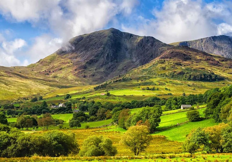
The Wicklow Mountains Challenge, starting from the charming village of Aughrim in County Wicklow, offers a rugged and rewarding hike across Ireland's rolling uplands. Covering approximately 26 kilometers with an elevation gain near 800 meters, this trail demands respect—it is a conversation with the mountain itself, framed by roots gripping forest floors and wind that whips across exposed ridges.
Your journey begins amid whispering oak and conifer woodlands where shafts of light puncture the canopy, dappling moss and leaves beneath your boots. The path here is uneven and often muddy, so solid footwear is non-negotiable. Streams nearby seem to dare you onward, their currents lively and insistent.
As you break tree cover, vistas widen. The vast, heaving slopes of the Wicklow Mountains stretch out toward distant horizons, rocks like old bones beneath a bruised sky. The air sharpens; the mountain becomes a living partner in the trek, challenging your pace, rewarding your efforts with breathtaking views at points like Seefin and Seefingan peaks.
Expect varying terrain—peat bog patches that test balance, stony inclines demanding steady steps, and grassy shoulders where wind snakes freely over grasses. With adequate pacing, the route typically takes 7 to 9 hours, requiring endurance but not extreme technical skill. Hydration and energy management are key; refill opportunities are limited to natural sources well-filtered.
Plan to start early to maximize daylight and avoid afternoon winds, strongest here as the mountain exhales. Weather shifts quickly; layers and waterproofs are essential companions. Remember, this is a mountain that remains fiercely itself—respect for its moods ensures not just survival, but full immersion in the challenge and its rewards.
End your hike back in Aughrim, a small village offering welcome warmth in its local pubs and simple accommodations. The sense of accomplishment is tangible, earned through footfalls and respect for a landscape alive and unyielding.
Nearby Trips
All Adventures
Boat Charters
Water Activities
Adventures near Aughrim, County Wicklow
Discover the unique and memorable adventures that make Aughrim, County Wicklow special.
Frequently Asked Questions
Are there clear markings along the Wicklow Mountains Challenge route?
The trail has some markers, but hikers should carry a detailed map or GPS device as certain segments, especially in remote areas, can be confusing due to variable weather and trail wear.
What wildlife might I encounter on this hike?
Red deer and hare are common in the region, along with a variety of birds such as kestrels and ravens that use the thermals rising from the mountains. Early mornings and late afternoons are best for sightings.
Is the challenge suitable for novice hikers?
While the trail doesn’t require technical climbing skills, its length and elevation gain mean novice hikers should be in moderate physical condition and prepare for varied terrain and potentially inclement weather.
Are there places to refill water along the trail?
Natural streams and rivulets appear intermittently, but it’s wise to carry your full water supply and purification method as these sources may be sparse or contaminated.
What historical or cultural sites might be near the route?
Near Aughrim, you’ll find remnants of old monastic sites and traditional stone cottages. The area also holds importance for local folklore tied to mountain spirits and ancient pathways.
How should I prepare for sudden weather changes?
Weather can turn quickly—always carry waterproof clothing, keep electronics in dry bags, and monitor forecasts. Early starts can help avoid afternoon storms typical to the region.
Recommended Gear
Waterproof Hiking Boots
Provide ankle support and traction on wet and uneven ground, crucial on mixed terrain.
Water Filter or Purification Tablets
Enables safe hydration from natural streams, critical due to limited water stops.
Layered Clothing System
Lets you manage changing weather; moisture-wicking base with insulating mid-layers and a waterproof shell.
Trekking Poles
Helpful for balance on uneven paths and reducing strain on knees during descents.
Local Insights
Hidden Gems
- "Poulanass Waterfall, a secluded cascade a short detour from the main trail"
- "The rocky outcrop near Seefin peak offers a unique panorama often missed by hikers focusing on the main ridge"
Wildlife
- "Red deer"
- "Hares"
- "Kestrels"
- "Ravens"
History
"Aughrim and its surroundings feature ancient monastic ruins and ruins of early settlements, reflecting the area’s long-standing human-nature connection and importance as a cultural crossroads."