Pictured Rocks Days: Adventure Awaits on Munising’s Iconic Shoreline
Experience the raw beauty of Pictured Rocks National Lakeshore with hikes and water adventures that bring you close to Lake Superior’s towering cliffs and forest trails. This guide offers practical tips and detailed insights to help you plan your journey and embrace the rugged landscape of Munising with confidence.
Start Early to Beat the Crowd
Begin your hike before 8 a.m. to enjoy quieter trails and cooler temperatures, especially during summer months when the park sees a surge of visitors.
Wear Traction-Supporting Footwear
Choose boots or trail shoes with firm ankle support and good grip to handle rocky outcrops and slippery surfaces without compromising comfort.
Carry Adequate Water and Snacks
Although shaded, the trail can be physically demanding. Bring at least 2 liters of water and energy-rich snacks to maintain endurance.
Use Trail Maps and Stay on Marked Paths
Pictured Rocks is straightforward but marked trails can fade or be confusing near cliff edges—pay attention to signage and avoid shortcuts to protect the environment.
Pictured Rocks Days: Adventure Awaits on Munising’s Iconic Shoreline
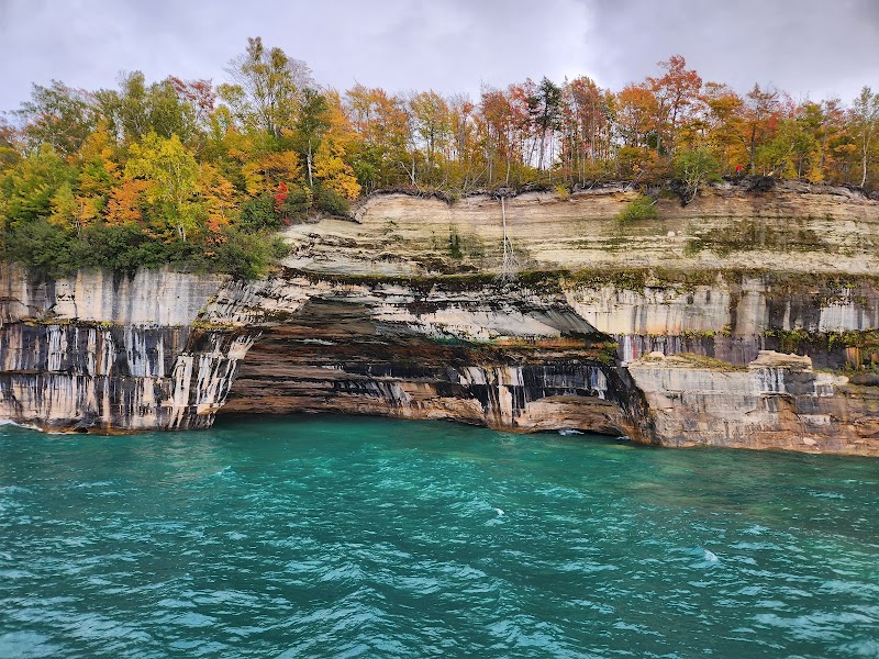
Munising, Michigan, offers a sharp call to those who seek the edge where land meets Lake Superior. The Pictured Rocks National Lakeshore demands attention—not from afar, but up close, on foot and by water, where sheer sandstone cliffs dare you to match their wild character. This is not a stroll but an engagement with a landscape fiercely itself: forested trails shake with the crunch of pine needles beneath your boots, while cliffs rise with unapologetic grandeur, cutting jagged profiles against the sky.
The most traveled route, the Lakeshore Trail, stretches approximately 42 miles one-way, but experience can be tailored. A popular day hike segment from Munising to Miners Castle covers roughly 4 miles round-trip with under 500 feet of elevation gain—manageable for most but rewarding with spectacular views. Terrain varies from well-packed dirt to rocky outlooks; expect root-strewn paths through dense hardwoods that breathe coolness into the air.
Hydration is key, especially under summer sun. The forest shields but doesn’t completely deny heat. Footwear benefits from sturdy grip and ankle support; the rocky sections test your balance and resolve. Early morning starts beat crowds and catch the cliffs bathed in softer light, offering ideal conditions for both hiking and photography.
Beyond the trail, kayak rentals from Munising provide another way to engage with Pictured Rocks, where water pushes forward, revealing caves and waterfalls inaccessible by foot. In cooler months, snowshoeing turns trails into quiet contrasts of white and color. Pictured Rocks is best approached with respect—the environment is dynamic, weather shifts quickly, and Lake Superior’s currents remind all who venture here that they intersect with forces larger than themselves.
Navigation is straightforward but remains essential. Maps and expert local advice keep your day safe and efficient. Take time to notice the subtle: spring flowers uncertainly reaching for sun, bald eagles riding thermals, the sudden hush when the wind drops. This is nature in conversation, challenging and welcoming.
To prepare, focus on layering clothes to adapt to sudden temperature changes, and carry enough water and snacks to sustain energy on a trail that, while not alpine, demands steady effort. With each step, you’re not just hiking a path—you’re traversing a shoreline that writes its history daily against rock and wave. Pictured Rocks isn’t a backdrop; it’s an active participant, waiting for those willing to keep pace.
Nearby Trips
All Adventures
Boat Charters
Water Activities
Adventures near Munising, Michigan
Discover the unique and memorable adventures that make Munising, Michigan special.
Frequently Asked Questions
What is the best section of Pictured Rocks for a day hike?
A 4-mile round trip from Munising to Miners Castle provides exceptional cliff views and manageable terrain, suitable for most hikers wanting a day trip experience.
Are dogs allowed on the trails?
Yes, dogs are permitted but must be kept on a leash to protect local wildlife and preserve the natural environment.
When is the water level ideal for kayaking along Pictured Rocks?
Late spring through early fall usually offers calm waters suitable for kayaking, but always check weather and lake conditions due to sudden currents and wind.
Are there any safety concerns with cliff edges on the trail?
Yes, cliff edges are often unguarded and can be unstable; hikers should stay on marked paths and keep a safe distance from the edges.
What wildlife might I see on this hike?
Keep an eye out for bald eagles soaring, white-tailed deer, and occasionally black bears. Early mornings increase chances of animal sightings.
Is there cell service in the park?
Cell service is limited in many areas, so prepare by downloading maps and informing someone of your plans before heading out.
Recommended Gear
Sturdy Hiking Boots
Provides stability and protection on rocky and root-covered sections of the trail.
Hydration System or Water Bottles
Carrying enough water keeps energy levels steady during longer hikes in exposed areas.
Layered Clothing
Allows you to adjust to rapid temperature changes along the lakeshore and inside forested parts.
Daypack with Snacks and Safety Kit
Keeps essentials like maps, first aid, and energy food within easy reach.
Local Insights
Hidden Gems
- "Au Sable Point Lighthouse offers dramatic views without heavy crowds."
- "Mosquito Falls Trail features a quiet cascade and fewer hikers."
Wildlife
- "Bald eagles frequent the area especially near open water in spring."
- "River otters can be spotted along lower creek areas."
History
"The sandstone cliffs were sacred to the Ojibwe people before the area became a national lakeshore. Early logging and fishing industries shaped the nearby town of Munising."