Navigating Meeting Points and Trail Changes in Freedom, NH: A Practical Guide
Freedom, NH, offers a network of trails perfect for adventurers eager to blend exploration with thoughtful route planning. This guide covers key meeting points and tips for transitioning between trails, helping hikers navigate terrain that swings from dense forest to sweeping ridge views with confidence and ease.
Confirm Vehicle Parking Before Starting
Parking at popular trailheads like Mount Shaw can fill early. Arrive before 8 a.m. to secure a spot and avoid wasting time searching for alternatives.
Use Trail Maps and Markers Religiously
Signage is good but not always clear. Carry a detailed printed map or GPS device to navigate trail intersections carefully and avoid unintended detours.
Plan Transitions Around Elevation Gains
Trail connections often involve elevation changes that impact timing and energy. Consider elevation profiles when planning your route to maintain steady pacing.
Pack Hydration and Snacks Strategically
Forest transitions can cool you down while ridge stretches expose you to sun and wind. Keep water easily accessible and snacks handy to maintain energy.
Navigating Meeting Points and Trail Changes in Freedom, NH: A Practical Guide

Full Day Bicycle Tour/Lesson
Starting from $320 | 5-8 Hours | Up to 8 People | Ride the Back Roads
Discover New Hampshire's scenic landscapes on a private bicycle tour with expert lessons included. Perfect for all skill levels, this full-day adventure offers stunning views and personalized guidance to enhance your riding experience.
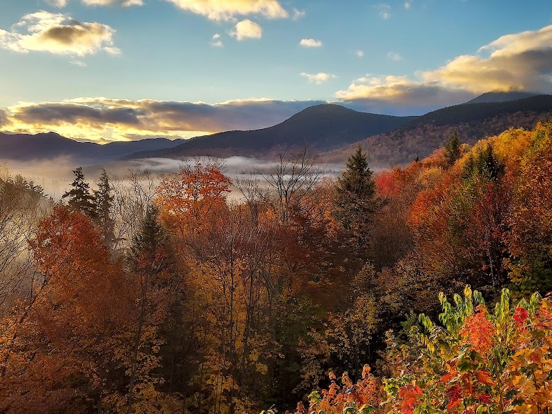
Freedom, New Hampshire, presents a rugged yet accessible network of trails that invite hikers to piece together adventures with carefully chosen meeting points and trail transitions. Its terrain shifts between dense spruce forests and open ridgelines, making clear planning essential to move smoothly from trail to trail without losing momentum or daylight. Meeting points here often mark shifts not just in scenery, but in challenge—from moss-carpeted paths that quiet your steps to rocky ledges that demand focus.
Begin by pinpointing established trailheads such as the Mount Shaw Trail or the Blueberry Mountain Trail. Both act as reliable gateways with parking often limited but well-maintained. These spots function as logical hubs where groups regroup or solo trekkers start fresh. Keep an eye out for signage at trail intersections, which occasionally require close reading to avoid missteps—especially where unofficial side trails weave through dense forest patches.
Transitioning between trails involves recognizing both distance and elevation changes. For example, connecting the Red Hill Trail to Parker Trail involves a manageable 2.5-mile trek with roughly 800 feet elevation gain pushed by intermittent footing of roots and loose stone. The land here dares your attention, the terrain’s conversational shifts warning against rushing. Shoes with solid grip and ankle support become your allies as the path snakes through stands of hardwoods and firs, each tree seeming to lean in, watching your passage.
Timing also plays a crucial role. Early morning departures capitalize on cooler air and catching the eastern light unlocking views from ridge lines that unfurl like a quiet reward. Midday brings heat, and some transitions bring open spots where the sun presses hard against skin and water needs quick replenishing. The wooded portions offer respite, filtering sunlight into dappled patterns on leaves that shift with even the gentlest breeze.
When planning your route with meeting points in mind, consider your group’s pace and stamina. Trails in Freedom vary from steady climbs that test endurance to gentler slopes suited for relaxed exploration. Linking multiple trails for a full-day hike requires realistic assessment of distance, terrain, and transition times. Pack accordingly—extra hydration, layered clothing for temperature swings, and quick energy snacks are practical musts.
Trail intersections sometimes surprise with unexpected vistas or quiet glades perfect for pause and regrouping. Freedom’s landscape holds a fierce independence that rewards respect—a place where feeling the pull of the rivers, the hum of forest, and the strain of the climb makes each transition more than a marker—it becomes part of the journey itself. Take these considerations seriously and your navigation will remain confident and fluid, making your hike in Freedom a seamless engagement with a landscape fiercely itself.
Nearby Trips
All Adventures
Boat Charters
Water Activities
Adventures near Conway
Discover the unique and memorable adventures that make Conway special.
Frequently Asked Questions
Are the trailheads in Freedom, NH easily accessible by car?
Yes, most major trailheads like Mount Shaw and Blueberry Mountain have designated parking areas. However, spaces fill early in the day, especially on weekends, so arriving before 8 a.m. is recommended. Some smaller trailheads have limited or no parking so planning vehicle logistics ahead is essential.
How difficult are the trail connections in terms of elevation and terrain?
Transitions often involve moderate elevation gains averaging 500-1,000 feet, with terrain shifting between soft forest floor and rockier sections. Hikers should be prepared for steady climbs and occasional uneven footing but technical climbing is minimal.
What wildlife can I expect to see along these trails?
Deer, turkeys, and a variety of songbirds are common. Black bear sightings are rare but possible—make noise to alert animals of your presence. Early morning and dusk increase chances of observing wildlife activity.
Is it safe to hike alone when transitioning between trails here?
Solo hiking is possible but requires careful preparation. Carry a map or GPS, inform someone of your planned route and expected return, and remain aware of trail intersections which can be confusing. Cell service may be spotty in certain forested areas.
Are there any lesser-known viewpoints worth visiting during transitions?
Yes. The smaller ledges along the Parker Trail near the junction with Red Hill Trail offer quiet panoramic views without the crowds found on Mount Shaw’s summit. These spots reward hikers willing to leave popular paths briefly.
What environmental considerations should hikers keep in mind here?
Protecting the fragile forest understory and water sources is vital. Stay on marked trails, avoid shortcuts, and pack out all trash to preserve the area’s natural integrity. Seasonal trail erosion can occur, so use care during wet periods to limit impacts.
Recommended Gear
Sturdy Hiking Boots
Provides ankle support and grip necessary on rocky or root-strewn paths common when transitioning between trails.
Hydration System
Water bottles or hydration packs help you maintain steady hydration through the warmer, exposed sections of the trails.
Layered Clothing
Ideal for adjusting to temperature swings ranging from forest shade to open ridgelines.
Trail Map or GPS Device
Key tool for avoiding missed intersections or tricky trail transitions, especially where signage is sparse or ambiguous.
Local Insights
Hidden Gems
- "Quiet viewpoints along Parker Trail offering expansive views of Ossipee Lake"
- "Small rock outcrops on lesser-used side trails that showcase delicate mosses and ferns"
Wildlife
- "White-tailed deer"
- "Wild turkeys"
- "Eastern chipmunks"
- "Occasional black bear signs"
History
"Freedom was logged extensively in the 19th century, and some old stone walls and foundation remnants still appear near trail edges, hinting at early settler homesteads."