Witzenberg Mountain Bike Challenge: Conquer the Western Cape’s Fierce Trails
Tackle the Witzenberg Mountain Bike Challenge to experience one of Western Cape’s most demanding and scenic mountain rides. Spanning 65 kilometers of varied terrain, this route invites cyclists to engage deeply with rugged climbs, forested trails, and expansive valley views while offering vital tips for preparation and endurance.
Hydrate Strategically
Carry at least 2 liters of water and refill at known points; the heat and elevation gain quickly dehydrate riders even on cooler days.
Choose Durable Footwear
Sturdy shoes with good ankle support protect against rocky paths and sudden descents, reducing the risk of injury.
Time Your Ride Early
Start in the morning to avoid the midday sun and capture optimal trail conditions before afternoon winds pick up strongly.
Mind the Weather Shifts
Mountain weather can change abruptly; pack a light waterproof jacket and be ready for slippery terrain if rain arrives.
Witzenberg Mountain Bike Challenge: Conquer the Western Cape’s Fierce Trails
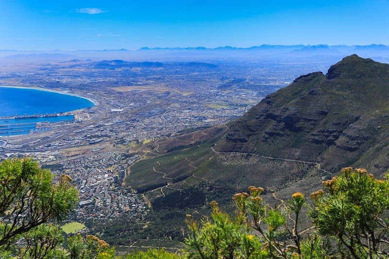
The Witzenberg Mountain Bike Challenge offers a rugged yet rewarding experience for cyclists keen on testing their endurance against the raw elements of the Western Cape. This 65-kilometer route stretches across varied terrain — from steep mountain passes and gravel tracks to forested sections and open farmland — with a cumulative elevation gain approaching 1,800 meters. The mountains here don’t yield easily; each climb demands respect as the terrain pushes your focus and strength.
Starting near the town of Ceres, riders quickly find themselves immersed in a landscape alive with movement. Streams cross the path and dare you to maintain speed, while rocky patches force a mindful pace. Narrow forest corridors close in overhead, their shadows offering brief relief from the sun, before giving way to expansive lookout points where the valleys open wide, revealing the rugged outline of the surrounding peaks.
The challenge isn’t just physical. The wind often picks up without warning, racing through the ridges and testing your balance. Rainfall can turn trails slippery, reminding you this mountain remains fiercely itself, demanding both preparation and humility. Proper tire choice—preferably one with strong grip—combined with timely hydration and pacing makes all the difference.
Timing your ride early to mid-morning helps avoid the hottest hours, while still allowing the platform to absorb the morning light, enhancing visibility on technical descents. Footwear with solid ankle support and a durable sole will guard against sharp rocks and uneven ground, especially important on the more rocky segments.
Whether you’re a seasoned mountain biker or a fit enthusiast stepping up your game, the Witzenberg Mountain Bike Challenge offers a blend of challenge and breathtaking scenery. Expect to move steadily, balancing bursts of speed with measured control. By the end, there’s not just the satisfaction of completing a tough ride but a clear connection to this uncompromising landscape. Every pedal stroke here places you in a dialogue with a mountain that’s alive, surging ahead, and rewarding those willing to meet it at its pace.
Nearby Trips
All Adventures
Boat Charters
Water Activities
Adventures near Witzenberg, Western Cape
Discover the unique and memorable adventures that make Witzenberg, Western Cape special.
Frequently Asked Questions
What is the total elevation gain on the Witzenberg Mountain Bike Challenge?
The route involves approximately 1,800 meters of elevation gain, featuring several steep climbs that require strong stamina and careful pacing.
Are there any water refill stations along the trail?
Limited. It is advisable to carry enough water for the entire ride, as natural water sources can be unreliable and springs may be seasonal.
What wildlife might I encounter during the challenge?
Expect to see small mammals like dassies (rock hyrax), birds of prey circling overhead, and occasional antelope grazing the lower slopes.
Is the route marked and easy to navigate?
The trail is clearly marked in most sections, but it's recommended to use a GPS device or detailed map due to occasional forked paths and private farmland crossings.
Are there resting spots or viewpoints along the route?
Yes, several points offer natural benches or flat ground with sweeping views of the Witzenberg valley, ideal for taking breaks and photos.
How challenging is the terrain technically?
The terrain varies from moderate gravel roads to steep rocky singletrack sections. Riders should feel confident in handling technical descents and sharp climbs.
Recommended Gear
Full-suspension Mountain Bike
Essential for absorbing impacts on rocky and uneven trails, increasing control and comfort.
Hydration Pack
Allows you to carry ample water and fluids for sustained hydration throughout the ride.
Protective Helmet and Gloves
Core safety gear to protect against falls and improve grip on handlebars.
Lightweight Waterproof Jacket
Helps keep you dry and protected against sudden rain or wind chill, especially in cooler months.
Local Insights
Hidden Gems
- "The 'Eagle's Perch' viewpoint on the northern ridge, offering a nearly 270-degree panorama of the valley below."
- "A quiet forest patch near the halfway mark, where bird calls dominate and shade comforts the tired rider."
Wildlife
- "Cape Rock Agamas can often be seen darting across rocks in sunny clearings."
- "Secretary birds occasionally patrol open areas hunting for snakes and rodents."
History
"The area around Witzenberg has a rich history linked to early agricultural settlements and the indigenous Khoisan people, with some trails once serving as old trade routes."