
What the day feels like
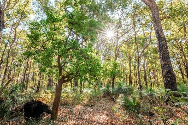
The trail begins where a small, historic cemetery watches the forest. You step over sun-warmed gravestones into a world that smells of dry eucalyptus and old timber—jarrah—the very wood that built towns across Western Australia. For four to five hours you move through a landscape that alternates between cool, ferned gullies and high ridgelines where the forest opens to folded sky. Streams thread down to a narrow gorge; at times the path slips close enough that water seems to call you forward, daring you to pause and listen. This is Kitty’s Gorge, a 15-kilometre return trail out of Jarrahdale that feels equal parts antidote and classroom: restorative in its hush, instructive in its geology and history.
The Darling Range is not dramatic in alpine terms, but its story is compact and intense. This band of lateritic uplands marks the ancient edge of Western Australia’s continental shield. Over millions of years, iron-rich soils baked into hard laterite while rivers and seasonal creeks sliced the softer layers, forming gullies and waterfalls such as nearby Serpentine Falls. When Europeans arrived in the 19th century, they found a forest of jarrah, a dense, rot-resistant eucalyptus that quickly became the region’s industry. Jarrahdale itself is one of Western Australia’s oldest timber settlements. Walking here is to move through the footprint of that industry—old logging tracks have become verdant trails, and the human and natural histories remain braided together.
The hike reads like a sequence of small acts rather than one sustained theatrical scene. You begin among cemetery gums and a scattering of heritage buildings, then drop into the creek system, crossing pebbled beds and stepping on exposed roots. Midway, gorges close in—granite outcrops polished by decades of wet seasons—while pockets of paperbark and fern fill the damp hollows. Listen for black cockatoos carving silence with their calls and keep an ear out for wallabies at dawn and dusk. As you near the lower reaches, the path opens to views of the Serpentine River and cascades that collect in cool plunge pools during wetter months.
Practicalities are straightforward but matter. The full route is about 15 km return and typically takes 4–5 hours on a guided outing, which includes short interpretation stops to learn about local flora, fauna, and timber history. Terrain is mostly well-defined but uneven: expect dirt tracks, rocky sections through gorges, and occasional creek crossings that can be slippery after rain. This is not a technical climb, but good ankle support, steady footing, and sensible pacing pay dividends. Guided groups also pause for a relaxed lunch, often with recommendations to finish the day at Millbrook Winery for a look at local bottles—an easy local ritual that pairs tough walking with slow tasting.
Weather shapes the experience. In spring the jarrah understory flashes with wildflowers and the air feels fresh, while summer makes early starts essential to avoid heat. Winter brings wetter creeks and louder waterfalls; the rock can be slick, which is why a guide is helpful if conditions are variable. Cell service is intermittent through the deeper gorges, so turn off autopilot and tune into the ground underfoot and the birds overhead.
Culturally, the land carries deeper human stories than the timber era. The Darling Range is Country to local Noongar people; their seasonal knowledge and place names are threaded into the landscape. A respectful guided hike acknowledges that history—ask your guide about local cultural context and leave time for listening. Conservation is increasingly part of the trail conversation: jarrah forests are resilient but vulnerable to invasive species, altered fire regimes, and unplanned development. Leave no trace principles here aren't optional—they're part of keeping the place wild for the next group that comes through.
Who this hike suits is simple: day hikers with a moderate fitness base who enjoy forested trails, geology, and local history. Families can handle sections of the route if kids are used to walking a few hours, though younger children may prefer shorter loops. Photographers will find texture and light at every turn—bark, lichen, water reflections, and the vertical frames of tall trees.
When to go: spring for wildflowers and comfortable temperatures, shoulder months for fewer bugs, and late winter for the best waterfalls. What to bring: water (plan for 1.5–2 liters per person), a hat, sturdy boots with grip for creek crossings, and layers for changing weather. If you want to linger, book a tasting at Millbrook Winery afterward or explore Jarrahdale village for a slice of local cafe culture.
Kitty’s Gorge is not a stunt—its pleasures are small and accumulative. You won’t summit a peak, but you will pass through a living archive of soil, rock, and wood; you will hear a forest shaped by both natural process and human hands. That duality is the trail’s real draw: it offers an accessible, richly textured day in the Darling Ranges that leaves you cooler in the head and oddly heavy with the smell of jarrah on your clothes. If you walk here, go with curiosity and leave with a commitment to keep it as you found it.
Trail wisdom
Small choices, better day.
Start Early
Begin at first light in summer to avoid the hottest hours and to see wallabies active near dawn.
Footwear Matters
Wear sturdy boots with good grip for rocky gorge sections and slippery creek crossings.
Carry Water
Bring 1.5–2 liters per person; there are no guaranteed potable water sources on the route.
Respect Cultural Sites
Ask your guide about local Noongar history and avoid disturbing heritage features or sensitive areas.
Local knowledge
Read the place, not just the route.
Watch for native species including Western Grey Kangaroo, Carnaby's Black Cockatoo (seasonal).
Keep an eye out for wildlife during the transition between areas and habitats. Respect distance guidelines.
The jarrah forest ecosystem is managed for biodiversity and fire resilience; stick to trails, pack out all waste, and avoid disturbing waterways to reduce impact.
Follow the guide's instructions on size limits, ethical handling, and leave-no-trace practices.
Millbrook Winery tasting and views of orchard terraces. Jarrahdale village heritage walk and local cafes
Locally recommended viewpoints and quiet spots known best to local operators.
Jarrahdale was established as a timber town in the late 19th century when jarrah logging fueled regional development.
Maritime roots and regional tradition shape the waterways and working coasts.
Seasonal guide
Four versions of the same landscape.
Spring
Best forWildflowers · Mild weather · Birdwatching
ChallengesMore walkers on the trail · Variable showers
Spring offers wildflower displays and comfortable hiking temperatures—expect more visitors on weekends.
Summer
Best forEarly morning wildlife · Long daylight hours
ChallengesHigh heat · Increased sun exposure and insects
Summer requires early starts and sun protection; midday heat can be intense so plan accordingly.
Fall
Best forCooler hiking conditions · Clear light for photography
ChallengesShorter days · Occasional wind
Autumn brings crisp air and great light for photos; layers are useful as temperatures drop later in the day.
Winter
Best forLouder waterfalls · Fewer crowds
ChallengesSlick rocks · Higher chance of muddy sections
Winter delivers dramatic water flow but pack for wet, slippery conditions and possible creek rises.
Pack with intention
What to bring.
Good to know
Common questions.
The guided route is about 15 km return and typically takes 4–5 hours including stops.
Plan the edges
The details that make the day easier.
Jarrahdale was one of Western Australia’s earliest timber towns; its jarrah forests supplied much of the state’s early railway sleepers and buildings.
Post-hike, head to Millbrook Winery for a tasting of local wines and views; in Jarrahdale village, seek out a cafe or bakery for hearty pies and a community feel that connects the day’s walk to local life.
- Closest airport
- Perth Airport (PER). Trailhead: Jarrahdale cemetery—about a 1-hour drive (~60 km) from Perth. Cell service: intermittent in gorges. Permits: none typically required for guided hikes.
This area is managed for conservation; practice leave-no-trace, stick to established paths, pack out all waste, and avoid disturbing riparian vegetation and wildlife.
Explore by topic
Follow the threads.
Keep exploring
Make the story part of the trip.
Set out from Bass Harbor for a private, customizable day on Blue Hill Bay — lighthouses, puffins, seals, and the chance to feel Acadia from the water. Small groups, local captains, unforgettable views.
In four hours you can move from shaded canyon ferns to wind-scoured coastal ridgelines, guided by someone who knows where the light—and the hidden views—live. This private half-day hike on the Monterey Peninsula or Big Sur is compact, curated, and perfect for travelers who want depth without a multiday commitment.
 Related story
Beneath a sky of shifting light, Skaftafell’s ice reads like a map of time. This three-hour guided glacier hike mixes technical instruction with geology and culture: compact, safe, and unforgettable.