
What the day feels like
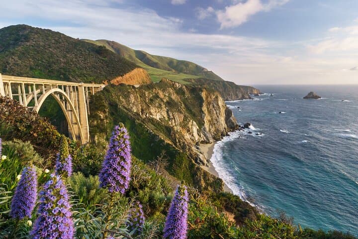
You pull onto Highway 1 and the coast takes over. The Pacific, slate and wind-driven, stretches left like a promise; cliffs, stubborn and layered, rise to meet it. In a private vehicle you trade the hurry of checkpoints for the measured pace of lookout points—stopping when a fog ribbon lifts, or when a stretch of beach seems worth a ten-minute walk. This is not a race but a conversation with the land: Bixby Creek Bridge arches like a question, McWay Falls answers by spilling directly into a cove, and the redwoods in Pfeiffer Big Sur State Park stand like old friends who have seen the road change more than once. On the Half Day Private Big Sur Driving Tour in California you get to steer that conversation, with a local voice in your ear via the Pintours App and the option to linger where you want.
Big Sur is a collage—geology, maritime climate, and human history stitched together on a narrow strip of California coastline. The rock is from ancient uplift and offshore faults, split and weathered into the dramatic bluffs you’ll see. Spanish missionaries passed through in the 18th century, and later artists and poets were drawn to the coast’s loner energy; today the route along Highway 1 stitches small communities and state parks together while protecting fragile ecosystems. The result is a landscape that feels curated for drama: sea stacks, a bridge so photogenic it’s a shorthand for the whole region, and waterfalls that drop straight into the ocean.
The tour leans practical. Expect a 2–3 hour private drive that covers roughly 25–35 miles of the most scenic stretch of Big Sur—enough time to savor the major sights without feeling rushed. Stops typically include Bixby Creek Bridge (a study in engineering and perspective), vantage points above Garrapata State Park, time to peer down at McWay Falls in Julia Pfeiffer Burns State Park, and the option to thread into a redwood stand or a hidden beach depending on conditions and your interests. Your local guide’s voice and the Pintours App—written by a longtime resident—give context: where the road treks through the youngest geology, which coves host harbor seals, and which pullouts afford the best light for photography. The tour is private, flexible, and designed so you can pause the narrative and stay longer at a view if the light is right.
This is a drive for people who want access without the logistics. There are short, flat walks to overlooks, but the physical demands are low—what you need instead is curiosity, a tolerance for coastal wind, and a camera. Cell service is spotty in places; that’s part of the attraction. The Pintours App mitigates this by allowing you to control the tour and access local commentary on your timetable. The trip’s local flavor is as important as the scenery: small cafés in Carmel-by-the-Sea or a roadside stand offering artichoke sandwiches and coffee make perfect bookends to a morning or afternoon out.
Practical notes matter here. Parking at Julia Pfeiffer Burns and other state parks can be limited—arrive early if you want to walk the main viewpoints. Weather changes fast: mornings often start foggy, afternoons clear, and evening fog returns. Dress in layers, bring a windproof jacket, and carry water even for a short outing. Photography is a key reason many travelers pick this route; golden hour from a cliffside pullout will repay patience in spades.
Why book a private half-day drive rather than drive yourself? It’s about curation. A local-led private tour funnels the best stops into a short window while avoiding the frustration of finding parking or missing a viewpoint hidden behind a low turnout. For travelers short on time—arriving from Monterey or Carmel for a day on the coast—the 2–3 hour window is efficient and intimate. If you want to upgrade to a longer day, guides often have suggestions for where to stretch the route: an extended hike in Pfeiffer Big Sur State Park, lunch in Nepenthe, or a sunset stop near Andrew Molera State Park.
This tour’s strengths are simplicity and control: private pacing, a local narrator (Bill Devoe is credited with curating this route), and the ability to pause the audio and stay at a spot that feels right. It’s an ideal pick for couples, photographers, small groups, or anyone who prefers to keep travel time tight while still absorbing the coastline’s best highlights. If you’re planning a longer stay in Big Sur, consider this short tour the perfect appetizer—enough to highlight the region’s peaks and pockets, and to orient you for deeper exploration later. For booking and details, see the Half Day Private Big Sur Driving Tour listing for a direct link and to preview the stops and flexibility offered by the Pintours App: https://app.advcollective.com/local-experts/half-day-private-big-sur-driving-tour-bixby-bridge-to-mcway-falls.
When the drive winds down, there’s the satisfying feeling that you have seen more of the coast’s defining moments than you might achieve alone in the same time. The ocean keeps daring you to come back; the cliffs stand patient. Half a day here leaves you with a clear map of favorites for a future longer stay.
Trail wisdom
Small choices, better day.
Dress in layers
Coastal weather shifts quickly—start with a windproof outer layer and add or remove midlayers as fog or sun appears.
Arrive early for key viewpoints
Parking at state park pullouts and McWay Falls is limited; mornings or late afternoons are best for space and light.
Download the Pintours App
Use the app on this private tour to control stops, pause commentary, and access local insights even with spotty cell service.
Bring water and a small snack
There are few reliable services along the route—carry water, especially on warm days.
Local knowledge
Read the place, not just the route.
Watch for native species including Harbor seals, California sea otters.
Keep an eye out for wildlife during the transition between areas and habitats. Respect distance guidelines.
Much of Big Sur is protected through state parks and private conservancies—stay on designated paths, avoid trampling sensitive vegetation, and pack out all trash to protect nesting shorebirds and fragile bluff habitats.
Follow the guide's instructions on size limits, ethical handling, and leave-no-trace practices.
Garrapata Headland for quiet tidepooling and coastal wildflowers. Small, cliffside pullouts south of Bixby with lesser-known sunset views
Locally recommended viewpoints and quiet spots known best to local operators.
Big Sur’s coastline has been shaped by Indigenous Esselen and Ohlone communities and later by Spanish-era land grants; the modern Highway 1 corridor was completed in the 1930s and transformed access to the coast.
Maritime roots and regional tradition shape the waterways and working coasts.
Seasonal guide
Four versions of the same landscape.
Spring
Best forWildflowers · Milder temperatures
ChallengesUnpredictable rain · Still-cool ocean breezes
Spring brings blossoms along the hillsides and comfortable daytime temperatures, though occasional coastal downpours are possible.
Summer
Best forClear afternoon light · Longer days
ChallengesMorning fog (June gloom) · Crowded viewpoints
Summer afternoons often clear to brilliant skies; expect fog in the morning and plan for higher visitor numbers.
Fall
Best forStable weather · Golden light for photography
ChallengesShorter daylight hours · Potential for late-season fires in dry years
Fall generally offers the most stable weather and excellent light for photography—ideal for a half-day drive.
Winter
Best forStorm-watching · Quieter roads
ChallengesRain and potential road closures · Cold, windy conditions
Winter delivers dramatic storms and fewer visitors, but check road conditions for mudslides or closures before heading out.
Operator details
What the booking data adds.
Included
- ✓Free navigation and Smartphone Guide
- ✓Pintours App Guide
Good to know
- ✓Infants are required to sit on an adult’s lap
- ✓Service animals allowed
- ✓Public transportation options are available nearby
- ✓Infants and small children can ride in a pram or stroller
- ✓Suitable for all physical fitness levels
Pack with intention
What to bring.
Good to know
Common questions.
This private tour runs about 2–3 hours and typically includes stops at Bixby Creek Bridge, scenic turnouts along Highway 1, and McWay Falls, with optional detours into redwood groves or beaches depending on time and conditions.
Plan the edges
The details that make the day easier.
Bixby Creek Bridge, completed in 1932, was one of the highest single-span concrete bridges in the United States and has since become an iconic symbol of Highway 1.
After the drive, stop in Carmel-by-the-Sea for clam chowder or a local seafood plate, or grab a coffee and a view at a Carmel café; Nepenthe in Big Sur offers sunset drinks with a cliffside panorama.
- Closest airport
- Monterey Regional Airport (MRY, ~45–60 min). Driving distance from Carmel-by-the-Sea: 20–45 minutes to common start points. Cell service: spotty; download maps
- fees
- some state parks have day-use
Big Sur’s ecosystems are fragile—stick to marked trails, avoid disturbing tidepools, pack out trash, and use established parking to limit erosion and habitat loss.
Explore by topic
Follow the threads.
Keep exploring
Make the story part of the trip.
Set out from Bass Harbor for a private, customizable day on Blue Hill Bay — lighthouses, puffins, seals, and the chance to feel Acadia from the water. Small groups, local captains, unforgettable views.
In four hours you can move from shaded canyon ferns to wind-scoured coastal ridgelines, guided by someone who knows where the light—and the hidden views—live. This private half-day hike on the Monterey Peninsula or Big Sur is compact, curated, and perfect for travelers who want depth without a multiday commitment.
 Related story
Beneath a sky of shifting light, Skaftafell’s ice reads like a map of time. This three-hour guided glacier hike mixes technical instruction with geology and culture: compact, safe, and unforgettable.