
What the day feels like
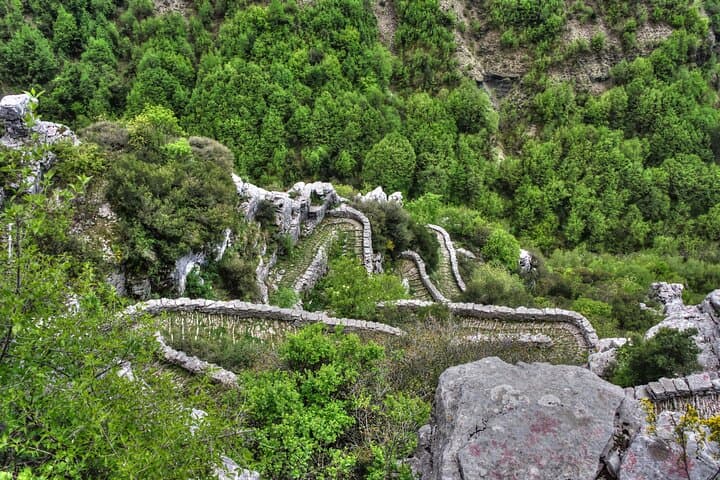
By the time the sun clears the lip of the Pindus range, the gorge yawns open like a folded map. From Beloi viewpoint, the drop looks theatrical and immediate: pale limestone cliffs plunge, terraces of juniper and oak stitch into a green carpet, and somewhere down in the throat the Voidomatis river threads a silver line. You feel both small and steady here, standing on a centuries-old stone path that has ferried shepherds and traders across Zagori for generations.The trail to Beloi is the sort of day hike that balances show-stopping scenery with a satisfying body-workout. It unfolds on the region's famous kalderimi — packed, hand-laid stone pavements — that trace the watershed like veins. What’s remarkable is how human craft and geology converse: manmade bridges arc over streamlets, dovetailing with the gorge's raw verticality. The route is a practical, tactile experience of place; every step on those stones is an argument about why the region was inhabited and connected despite its steepness.History lives in the masonry. Zagori's villages, including the hamlets that serve as trailheads, built these routes and the elegant single-arch stone bridges during the Ottoman era to facilitate movement and trade. Those bridges are more than ornaments; they are functional monuments to a communal life adapted to the mountains. UNESCO hasn’t listed every structure here, but local authorities classify many bridges and kalderimi as historical monuments, and you can sense their pedigree underfoot.Geology gives the Gorge its character. Vikos was carved by relentless water and time: limestone and flysch layered and fractured, weakened by glacial and fluvial action, then cut deep by the Voidomatis and its tributaries. The gorge is famous for its extreme depth-to-width ratio — a fact that drew early naturalists and later made it a point of national pride. Vegetation clings in banded terraces; in the shade of the cliffs, moss and rare endemic herbs find niches that feel deliberately hidden.Culturally, Zagori is stitched from stone and hospitality. Monodendri, Papigo and other villages offer stoas and kafeneia where shepherds meet and travelers trade directions. The cuisine is rooted in what the mountains give: pies made with local greens, smoked cheeses, hearty stews, and honey from slopes where bees forage on wildflowers. If you time the walk right, you can be back in a tavern by early afternoon with time to sit, sip tsipouro, and let the day fold over your shoulders.Practicality first: plan on 4–6 hours on the trail, depending on pace and side explorations. Expect roughly 10–12 kilometers overall with about 500–700 meters of cumulative elevation gain; terrain alternates between paved kalderimi, narrow dirt tracks, and exposed viewpoints where footing is uneven. The most exposed sections demand steady hiking shoes and attention to footing, but there is no technical climbing or rope work required. For many, the trail’s tempo mirrors the geology — long, patient stretches punctuated by abrupt vertical revelations.Timing matters. Spring and early summer bring wildflowers, flowing streams, and the most comfortable temperatures for sustained hiking. Fall is crisp and luminous, with clear skies and fewer crowds. In summer the rim heats quickly and shade becomes a luxury; winter can close the route depending on snow and ice. Start early to avoid afternoon heat and to catch the best light down in the gorge.As for logistics, this hiking day is often offered as a private guided tour with instant confirmation and a price point around 149 USD per person. Guides deepen the route with local stories — the who, why and when of bridges and the flora used for traditional remedies — and they handle navigation and safety. If you opt to self-guide, download offline maps or carry a GPS track and be prepared for patchy cell service in the deeper sections.Tips that make the day smoother: wear broken-in hiking shoes with good grip, carry at least 2 liters of water, bring sun protection and a light waterproof shell, and budget time for photography and picnic breaks. The viewpoint itself is sensational at golden hour, but avoid lingering on narrow promontories if groups are passing—respect and common sense keep the place accessible to everyone.Sustainability is straightforward here: these paths are living infrastructure. Stick to established trails, avoid trampling fragile vegetation on scree benches, pack out trash, and favor local guides and tavernas so the economic benefits stay in the villages. The Vikos-Aoos area is managed with conservation priorities; your small choices — polite behavior around wildlife, no souvenir chopping of juniper or herbs — make a difference.In short, a day at Beloi is an argument for slow, attentive travel: you come for the drop, you stay for the masonry, the geology and the people who still move along the stones. The hike is ambitious enough to feel earned, but not so technical that it shuts out curious travelers. For those who care about scenery that carries a story, and a trail that rewards patience, Beloi delivers in a way few short hikes do.
Trail wisdom
Small choices, better day.
Start at first light
Begin early to catch cooler temperatures, softer light for photos, and calmer winds on the rim.
Respect the kalderimi
Walk on the paved stones where present to avoid eroding the edges and damaging historic masonry.
Hydrate and snack often
Carry 2 liters of water and salty snacks; the terrain is steady and you’ll burn more energy than you think.
Mind the cliff edges
Photo stops can be narrow—give way to others and avoid loose overhangs.
Local knowledge
Read the place, not just the route.
Watch for native species including Griffon vulture, Hare (mountain hare and local wild mammals).
Keep an eye out for wildlife during the transition between areas and habitats. Respect distance guidelines.
The Vikos-Aoos area is managed for biodiversity and cultural heritage; stick to paths, pack out waste, and support local businesses to protect the landscape.
Follow the guide's instructions on size limits, ethical handling, and leave-no-trace practices.
A short side trail to a smaller terrace viewpoint near the main rim with fewer visitors. Nearby village kafeneio where shepherds drink morning coffee and sell local cheese
Locally recommended viewpoints and quiet spots known best to local operators.
The kalderimi and stone bridges of Zagori were built and maintained by village communities during Ottoman rule, facilitating trade and seasonal movement.
Maritime roots and regional tradition shape the waterways and working coasts.
Seasonal guide
Four versions of the same landscape.
Spring
Best forWildflowers · Moderate temperatures · Full streams
ChallengesMuddy patches · Cool mornings
Spring offers the richest plant life and flowing streams, with comfortable daytime hiking temps but chilly starts.
Summer
Best forLong daylight · Clear skies · Tavernas open
ChallengesHeat on exposed ridges · Fewer shade options
Summer brings bright, stable weather but plan early starts and sun protection to avoid midday heat.
Fall
Best forCrisp air · Clear vistas · Fewer crowds
ChallengesShorter days · Potential for sudden storms
Autumn delivers crisp visibility and color; bring layers for wind and early darkness.
Winter
Best forSnowy vistas · Quiet trails
ChallengesSnow and ice on exposed sections · Limited services
Winter can be beautiful but unpredictable—check local conditions and consider crampons if icy.
Operator details
What the booking data adds.
Included
- ✓Private transportation
- ✓Experienced and certified guide
- ✓Bottled water
- ✓Snacks
- ✓All Fees and Taxes
- ✓Photographic & video material
- ✓Hiking poles (optional)
Not included
- —Lunch
Good to know
- ✓Not recommended for travelers with spinal injuries
- ✓Not recommended for pregnant travelers
- ✓Not recommended for travelers with poor cardiovascular health
- ✓Travelers should have at least a moderate level of physical fitness
- ✓Mountain sports shoes or hiking boots, waterproof jacket, canteen, walking or hiking sticks and backpack.
Pack with intention
What to bring.
Good to know
Common questions.
Expect 4–6 hours and roughly 10–12 km with 500–700 m of cumulative elevation gain; overall difficulty is moderate.
Plan the edges
The details that make the day easier.
Vikos Gorge is noted for its extreme depth-to-width ratio and has been cited in literature as one of the deepest gorges in the world by proportional depth.
After the hike, eat in Monodendri or Ioannina: try local pies and grilled mountain cheese, pair with tsipouro, and linger at a lakefront café in Ioannina for trout and views.
- Closest airport
- Ioannina (IOA); Driving distance: ~40–60 minutes from Ioannina; Cell service: Patchy in gorge; Permits: None usually required for day hikes; Guided tour available with instant confirmation.
These are living cultural paths in a protected landscape—stay on marked trails, pack out waste, give wildlife space, and hire local guides to support village economies.
Explore by topic
Follow the threads.
Keep exploring
Make the story part of the trip.
Set out from Bass Harbor for a private, customizable day on Blue Hill Bay — lighthouses, puffins, seals, and the chance to feel Acadia from the water. Small groups, local captains, unforgettable views.
In four hours you can move from shaded canyon ferns to wind-scoured coastal ridgelines, guided by someone who knows where the light—and the hidden views—live. This private half-day hike on the Monterey Peninsula or Big Sur is compact, curated, and perfect for travelers who want depth without a multiday commitment.
 Related story
Beneath a sky of shifting light, Skaftafell’s ice reads like a map of time. This three-hour guided glacier hike mixes technical instruction with geology and culture: compact, safe, and unforgettable.