
What the day feels like
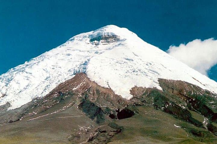
<p>The bus exhales as it climbs out of Quito’s grey, high-altitude sprawl and the city shrinks into a quilt of corrugated roofs. In its place the Andes open—stubbled farmland, rolling paramo, then an abrupt, almost theatrical reveal: Cotopaxi’s cone rising immaculate and white against an impossible blue. You feel the altitude before you notice it—the air thinner, the sun sharper, the land pronounced and clean. This is a ritual as much as a destination: two hours from Ecuador’s capital, and suddenly you’re within the salt-and-ash gravity of a volcano that has shaped landscapes, myths and weather for millennia.</p>
<p>At 5,897 meters (19,347 feet) Cotopaxi is one of the world’s highest active volcanoes and an icon of the northern Andes. The day tour from Quito is admirably straightforward: a private transfer that uses the two-hour drive as a buffer—time to hydrate, to listen to the guide explain the mountain’s recent activity and the fragile ecosystem you’re entering. The core experience is not a summit push (that’s for mountaineers with acclimatization and technical gear), but a full, immersive day inside Cotopaxi National Park: panoramic viewpoints, short guided walks across páramo grasslands, photos at Limpiopungo Lagoon, and the option to descend into the valley on a bike or even roller skates where terrain allows.</p>
<p>Geologically Cotopaxi is a stratovolcano—steep, layered with lava and ash, its near-perfect cone often capped with a glacier. The park around it is dominated by high Andean moorland (páramo), peat bogs and lava fields scarred by past eruptions. Humans have been reading Cotopaxi for centuries. Indigenous groups regard it as an Apu, a powerful mountain spirit; Spanish chroniclers described eruptions as omens that shaped colonial settlements. The area’s modern protection dates to the 1970s, when Cotopaxi National Park was established to conserve the high-altitude grasslands and water sources that supply surrounding valleys.</p>
<p>Culturally, this is an Andean landscape of working farms and resilient small towns—Latacunga and the villages ringing the park are places where market days retain a rhythm older than tourism. Local guides are often bilingual and blend natural history with stories: how llamas and horses grazed the slopes, how eruptions rerouted streams, how the community uses traditional crops like quinoa and melloco to endure the short growing seasons.</p>
<p>The practical shape of the day is efficient and frank. Expect a 7–8 hour outing including transportation. Most tours begin from Quito early, reach the park’s lower gateways, and then move up toward the Jose Rivas refuge area (around 4,800 m) for the best views of the glacier and cone. Terrain is variable: paved or gravel roads to the park, then compacted trail and mobbed volcanic scree at higher viewpoints. If you opt for a short acclimatized hike, you’ll climb gently across wet tussocks and volcanic gravel—altitude is the real challenge, not technical scrambling. For those looking for a different rush, the park offers downhill routes: guided mountain-bike descents or, in select areas, the quirky option of roll-skating down smoother sections—fast, joyous and entirely at odds with the solemn cone above.</p>
<p>Weather is decisive. Cotopaxi lives in a zone of rapid microclimates: clear, prime mornings can yield sudden cloud banks, and hours later gusts can drive snow across the summit. That volatility makes timing important; early departures maximize the chance of clear views. It also makes layering essential: sun at altitude is fierce, but wind and cold can arrive without fanfare.</p>
<p>Why go? For the proximity to Quito; for the cinematic quality of an almost perfect volcanic cone; for the blend of easy access and wild high-country feeling that doesn’t demand technical climbing. This trip is for travelers who want an elemental mountain day—accessible, dramatic, and anchored by real cultural context. It’s also for adventure-seekers who want a safe rush: a guided bike descent on volcanic trails is exhilarating without requiring months of training.</p>
<p>Preparing well will determine whether the day is a high point or a slog. Hydrate in Quito, sleep well the night before, and keep expectations realistic about altitude. Bring a windproof shell, sunscreen, and a camera with lens hoods—contrasting light and volcanic ash make for brilliant images, but wind and grit are constant companions. Use local guides. They know when to push for a higher viewpoint and when to pull back, what paths have footing and which are recent ash slides, and they also link the mountain to the people who live below it.</p>
<p>Logistics are straightforward: most tours include hotel pick-up in Quito and park fees are handled by the operator. The route itself is a parade of contrasts—subtropical city to alpine plain, cornfields to wind-shaped grass. Return to Quito around evening with a new appetite for roasted pork (hornado) or a shared bottle of Andean beer—both feel like proper bookends to a day at altitude.</p>
<p>In short, the Cotopaxi day trip is a concentrated highland experience: a chance to stand under a living mountain, to feel weather and elevation and geological time at once, and to do it with practical safety and cultural resonance. For a half-day of walking and a couple of heart-rate-raising descents, it delivers big—landscapes that look like postcards and a sense of having visited something elemental and real.</p>
<p>Book a guided option that includes acclimatization time and an experienced driver, and you’ll get more than a photo—you’ll get a roofline in a different world, and a day that rearranges your sense of scale.</p>
<p>Reserve a guided Cotopaxi National Park private tour here: <a href="https://app.advcollective.com/local-experts/cotopaxi-volcano-day-trip-from-quito-private-tour-to-cotopaxi-national-park">Cotopaxi Volcano day trip from Quito - private tour</a>.</p>
Trail wisdom
Small choices, better day.
Acclimatize before you go
Spend a night in Quito (2,850 m) and drink plenty of water before the tour to reduce altitude effects.
Layer for sudden weather
Bring a warm midlayer and a windproof shell—conditions shift fast above 4,000 m.
Protect your skin and eyes
High-altitude UV is strong—use SPF 50 and sunglasses with side protection.
Choose guided downhill options
If you want to bike or roll-skate, book a guided descent to ensure route-safety and equipment fit.
Local knowledge
Read the place, not just the route.
Watch for native species including Andean condor, Wild horses and feral cattle on park slopes.
Keep an eye out for wildlife during the transition between areas and habitats. Respect distance guidelines.
The páramo is fragile—stick to trails, avoid trampling vegetation, and use local guides who support community conservation efforts.
Follow the guide's instructions on size limits, ethical handling, and leave-no-trace practices.
Limpiopungo Lagoon—quiet lakeside views with reflections of Cotopaxi. Jose Rivas refuge area—excellent vantage point for glacier and cone photography
Locally recommended viewpoints and quiet spots known best to local operators.
Cotopaxi has been a landmark for indigenous cultures and colonial travelers; the National Park was established in 1975 to protect its unique highland ecosystems.
Maritime roots and regional tradition shape the waterways and working coasts.
Seasonal guide
Four versions of the same landscape.
Spring
Best forFewer crowds · Wildflower patches · Cool hiking conditions
ChallengesUnpredictable rain · Variable visibility
Spring brings a mix of clear days and sudden showers—great for flowers but be ready for wind and clouds.
Summer
Best forDrier weather · Clear summit views · Reliable biking conditions
ChallengesStrong sun · Cold nights
Summer (June–August) is the local dry season and offers the best odds for clear, panoramic views.
Fall
Best forGolden páramo light · Quieter trails · Crisp air
ChallengesShorter daylight · Temperature swings
Autumnal weeks bring stable light and cooler temps—pack warm layers for late afternoons.
Winter
Best forDramatic snow scenes · Fewer tourists
ChallengesSnow at higher elevations · Chilly conditions
Winter can bring snow and high winds; visibility is stunning on clear days but dress for serious cold.
Operator details
What the booking data adds.
Included
- ✓Private transportation
- ✓Pick up and drop off
- ✓Licensed Tour Guide
Not included
- —Tips
- —Use of bicycle
- —natural guide
- —Meals
- —The SIB, the admission to show the control and forest rangers, we are coming into the area.
Good to know
- ✓Wheelchair accessible
- ✓Service animals allowed
- ✓Public transportation options are available nearby
- ✓Infants are required to sit on an adult’s lap
- ✓Transportation options are wheelchair accessible
- ✓Not recommended for travelers with spinal injuries
- ✓Not recommended for pregnant travelers
- ✓Not recommended for travelers with poor cardiovascular health
- ✓Travelers should have at least a moderate level of physical fitness
Pack with intention
What to bring.
Good to know
Common questions.
Most private tours last 7–8 hours, including a roughly 1.5–2 hour drive each way depending on traffic and stops.
Plan the edges
The details that make the day easier.
Cotopaxi reaches 5,897 m (19,347 ft), making it one of the highest active volcanoes in the world and an enduring symbol in Andean culture.
After your return to Quito or Latacunga, try hornado (roast pork) with mote and a local craft beer; markets in Latacunga sell wool hats and artisan goods—support local vendors for meaningful souvenirs.
- trailhead
- Mariscal Sucre International Airport (UIO)
- Cotopaxi National Park entrance; Driving distance from Quito
- ~50–75 km (1.5–2 hours); Cell service: intermittent at higher viewpoints; Permits: park entrance fee required, summit permits separate
Cotopaxi’s páramo stores water and carbon—stay on trails, pack out trash, avoid single-use plastics and hire local guides who contribute to conservation and community income.
Explore by topic
Follow the threads.
Keep exploring
Make the story part of the trip.
Set out from Bass Harbor for a private, customizable day on Blue Hill Bay — lighthouses, puffins, seals, and the chance to feel Acadia from the water. Small groups, local captains, unforgettable views.
In four hours you can move from shaded canyon ferns to wind-scoured coastal ridgelines, guided by someone who knows where the light—and the hidden views—live. This private half-day hike on the Monterey Peninsula or Big Sur is compact, curated, and perfect for travelers who want depth without a multiday commitment.
 Related story
Beneath a sky of shifting light, Skaftafell’s ice reads like a map of time. This three-hour guided glacier hike mixes technical instruction with geology and culture: compact, safe, and unforgettable.