
What the day feels like
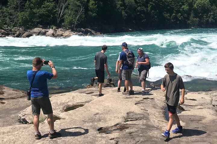
You step off the rim and into a different mood of Niagara: a narrower sky, the river’s voice turned urgent and close, and a corridor of stone that forces you to slow down. The Devil’s Hole to Whirlpool Loop drops you out of the tourist bustle and into the gorge’s geology—410 carved stone steps that lead straight into the cicada-sung understory and the thunder of water. The path hugs the Niagara River’s edge, threads through shale shelves and mossy boulders, and finishes with a view that feels earned: the Whirlpool’s roiling basin spread like a living mandala beneath Butterfly Rock. It is intimate, raw, and entirely unlike the postcard spectacle of Horseshoe Falls a few miles upstream.
The hike reads like a compact lesson in time. The gorge itself is the remnant of a cataclysm: when glaciers retreated at the end of the last Ice Age, meltwater carved a massive channel through layers of limestone, shale, and dolostone. Those exposed rock faces are a ledger of geological epochs—strata tilted, cracked, and smoothed by a river that still refuses to stand still. Human history layers on top. In the late 19th and early 20th centuries, the Niagara Gorge was an industrial corridor—rail lines, power infrastructure, and hydroelectric works shaped both the valley’s economy and its access. Today a New York State Licensed Hiking Guide leads small groups down this same route, pointing out traces of the old Niagara Gorge Railroad and the infrastructure of the New York Power Authority while you navigate narrow ledges and river-facing viewpoints.
What the brochure doesn’t fully convey is the sensory texture of the loop. The descent is a metronome of stone steps: a controlled, rhythmic effort that compresses the landscape. Down below, the river dares you—its eddies and swirls whisper of strength and stubborn motion. On the rim, wind carries a different language: the wide-open binary of spray and sky. Butterfly Rock, a flat outcrop above the Whirlpool Rapids, is a natural amphitheater where the current’s choreography is impossible to ignore. It’s one of those vantage points where you sit and let the river’s tempo reset you.
Practical expectations matter. This tour runs about 3–4 hours and typically covers roughly 2–3 miles (3–5 km) of trail with approximately 410 stone steps down and just over 400 steps back up—the return climb being the physical punctuation of the day. Terrain alternates between well-worn stone steps, narrow dirt paths, and occasional scramble over river-edge rocks; expect uneven surfaces and wet, slippery sections near rapids. Guides keep group sizes small and provide historical and safety context along the way, but you should be prepared: steady footwear, attention on footholds, and a measured pace will make the difference between a strain and a stride.
Timing is strategic. Start early to avoid tour buses and the mid-day crowds that gather at the rim. Spring and fall offer the best light for photography and cooler hiking temps; summer can be humid, and winter turns many sections into icy, technical slopes better suited for experienced hikers with crampons. The loop’s moderate distance and concentrated vertical make it accessible to fit hikers with a reasonable fitness base; the steps are mercilessly honest—no elevator shortcuts here.
Beyond logistics, the loop is a lesson in conservation and perspective. The fragile ribbon of riparian habitat along the gorge supports swallows, occasional mink and river otter sightings, and raptor activity in the cliffs. Stick to the trail, respect signage, and keep groups small; the trail’s narrow character magnifies impact. Guides emphasize Leave No Trace principles and point out how hydroelectric development reshaped the river’s flow and the local economy. The hike ends not just with a view but with context: you come away knowing how both geology and engineering wrote the gorge’s story.
For city visitors, the Devils Hole to Whirlpool Loop is a useful complement to the falls’ main attractions. It trades broad spectacle for concentrated intimacy; instead of jumping from vantage point to vantage point, you descend and become part of the landscape’s rhythm. You’ll need a moderate level of fitness, practical gear, and a willingness to climb—then the route returns you with a front-row seat to one of the river’s most hypnotic dramas.
If you go: plan for 3–4 hours, bring layered clothing and waterproof shoes, and give yourself time after the hike to walk the rim trails or visit nearby historical markers about the Niagara Gorge Railroad and early hydroelectric work. This is a day that rewards curiosity—ask your guide about the gorge’s shifting identity, and bring a camera with a wide lens (and a strap) to capture the Whirlpool’s spiraling motion.
Why travelers will want this: it’s a short, intensive escape from the crowds, a geology lesson with adrenaline, and a rare chance to see the Niagara River at eye level. The Devil’s Hole to Whirlpool Loop takes the raw energy of the falls and repackages it into a focused, human-sized adventure—one that leaves you with both a sweatband and a story.
Trail wisdom
Small choices, better day.
Respect the River’s Edge
Stay on marked trails and maintain distance from slick rock ledges—current and spray make the river’s edge hazardous.
Footwear First
Wear grippy hiking shoes or boots; the loop includes wet rock and uneven stone steps where traction matters.
Pace the Steps
Conserve energy on the descent and keep a steady, measured pace on the 400+ step climb back up to avoid fatigue.
Start Early
Begin early in the day to avoid crowds and to catch the best light for photos at Butterfly Rock and rim viewpoints.
Local knowledge
Read the place, not just the route.
Watch for native species including Peregrine falcon, River otter.
Keep an eye out for wildlife during the transition between areas and habitats. Respect distance guidelines.
The gorge is ecologically sensitive—stay on trails, carry out trash, and follow guide instructions to minimize erosion and habitat disturbance.
Follow the guide's instructions on size limits, ethical handling, and leave-no-trace practices.
Butterfly Rock—an intimate, flat outlook above the Whirlpool Rapids. Remnants of the Niagara Gorge Railroad visible along the rim trails
Locally recommended viewpoints and quiet spots known best to local operators.
The gorge was both a geological force and an industrial corridor; the old Niagara Gorge Railroad and hydroelectric development by the New York Power Authority shaped access and local industry.
Maritime roots and regional tradition shape the waterways and working coasts.
Seasonal guide
Four versions of the same landscape.
Spring
Best forWildflowers along the rim · Cool, brisk hiking · Fewer crowds
ChallengesMuddy trails · Runoff and increased river volume
Spring brings cool temperatures and thawing waterfalls—expect muddy sections and stronger currents; layers and waterproof footwear are recommended.
Summer
Best forWarm weather views · Longer daylight · Active river scenery
ChallengesHeat and humidity · Heavier visitor traffic
Summer is lively and accessible but can be humid and crowded—start early and pack extra water and sun protection.
Fall
Best forCrisp air and fall colors · Photogenic light · Moderate temperatures
ChallengesShortening daylight · Cool mornings
Fall is the sweet spot for many hikers: cooler temps and great light make for comfortable, scenic conditions—bring a warm layer for breezy rim viewpoints.
Winter
Best forDramatic ice formations · Quiet trails for experienced hikers
ChallengesIcy steps and trail closures · Limited services
Winter transforms the gorge but increases technical difficulty—many parts become icy and require traction devices; consider guided or experienced-only trips.
Pack with intention
What to bring.
Good to know
Common questions.
The guided tour typically lasts 3–4 hours and covers roughly 2–3 miles with about 410 steps down and a similar number back up.
Plan the edges
The details that make the day easier.
The Niagara Gorge was carved at the end of the last Ice Age—roughly 12,000 years ago—when glacial meltwater rapidly cut through the bedrock, creating the dramatic channel you hike today.
After the hike, head into Niagara Falls for casual regional fare—pizzerias, diners, and small cafes populate the area; for craft beer and a longer meal, nearby downtown neighborhoods and neighboring towns offer breweries and bistros.
- trailhead
- Niagara Falls International Airport or Buffalo Niagara International (~20–30 minutes). Driving distance from downtown Niagara Falls: 5–15 minutes depending on trailhead. Cell service: patchy in the gorge. Permits
- passes
- guided tour covers access—check for park entry
This section of the gorge supports fragile riparian habitat—pack out everything, stay on durable trail surfaces, and avoid feeding wildlife to reduce human-wildlife conflicts.
Explore by topic
Follow the threads.
Keep exploring
Make the story part of the trip.
Set out from Bass Harbor for a private, customizable day on Blue Hill Bay — lighthouses, puffins, seals, and the chance to feel Acadia from the water. Small groups, local captains, unforgettable views.
In four hours you can move from shaded canyon ferns to wind-scoured coastal ridgelines, guided by someone who knows where the light—and the hidden views—live. This private half-day hike on the Monterey Peninsula or Big Sur is compact, curated, and perfect for travelers who want depth without a multiday commitment.
 Related story
Beneath a sky of shifting light, Skaftafell’s ice reads like a map of time. This three-hour guided glacier hike mixes technical instruction with geology and culture: compact, safe, and unforgettable.