
What the day feels like
You feel the coastline before you see it: a cool, salt-scented breath that slips under the car windows and nudges the driver to slow. The road unwinds like a ribbon along the Pacific—tight curves that reveal cliffs, then a sudden vault of ocean and foam. On a private 4-hour coastal run from Monterey, that ribbon becomes an invitation to pick the views you want to keep. This is not a bus tour; it’s a local driver-guide in a luxury sedan, SUV, or Sprinter reading the light and the tides, stopping where the cliffs are dramatic and the crowds thin. It’s an efficient way to sample Big Sur’s geology, history, and coastal theater, with an optional highlight that still arrests most visitors: McWay Falls.
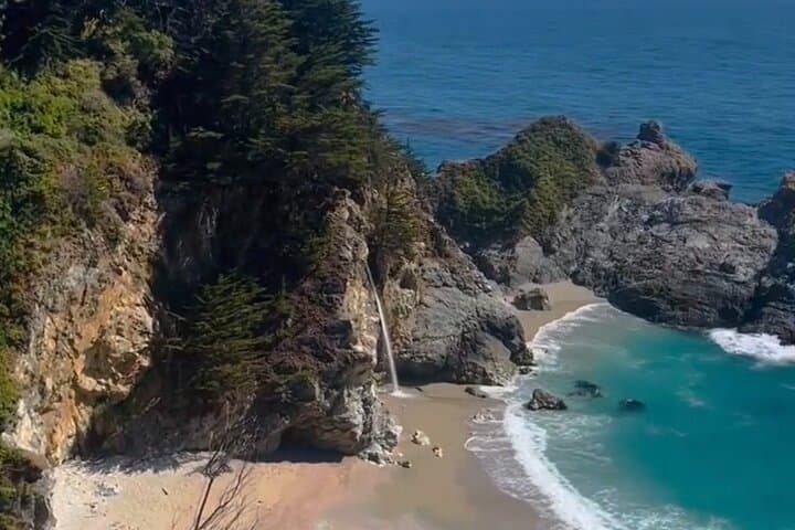
The waterfall—an 80-foot ribbon known as McWay Falls—has become shorthand for California’s moody, meteorological coastline. Once a true tidefall that fed a beach, a 1983 storm reworked the sandbar and shifted how the water meets the sea; now it spills onto a rocky amphitheater most days. You can view it from the Julia Pfeiffer Burns State Park overlook, where the trail is short, paved, and generous with angles for photos. To make that stop part of a curated half-day, book a private run to stitch together Bixby Creek Bridge, Pfeiffer Big Sur’s redwood groves, the River Inn, and a sunset pause at Nepenthe—your guide times it so you catch the light right.
Geologically, Big Sur is where the Santa Lucia Range drops off into the ocean. The cliffs are a raw map of uplift and erosion: folded, faulted rock running perpendicular to the shore. Driving it, you’ll notice layered outcrops and headlands that hug the waves. Historically, this coastline was home to the Esselen and Salinan peoples; later it became a refuge for homesteaders and artists drawn to its isolation. Nepenthe and other institutions dotting the route are as much cultural waypoints as restaurants—their terraces have hosted writers and musicians who found clarity in the salt air.
A private excursion like this offers two practical advantages. First, timing: your guide can target light and tides, moving a stop forward or back to avoid fog or crowds. Second, logistics: parking is a patchwork—popular pullouts fill fast and some of the best views are reached by short, protected overlooks. With a private vehicle for up to 12 people, you trade the fixed itinerary of group tours for a flexible, weather-aware plan that can include or omit McWay Falls depending on sea conditions and your group’s mood. If you want to commit to the falls, tell your guide: they’ll make the stop a priority and advise on camera positioning and timing.
Practical details matter here. The drive from Monterey to the McWay overlook is roughly 60–90 minutes depending on stops and traffic; total tour time is centered on a 4-hour or optionally 5-hour window. Walking at viewpoints is short and low-effort—most stops are paved or short gravel paths—but bring sturdy shoes if you plan to explore a little further. Cell service is intermittent; treat the guide as your navigation and communications hub. The weather is variable: mornings can be foggy, afternoons sunnier. Layering and sun protection will keep a half-day comfortable and focused on the coast, not the chill.
For photographers and contemplatives, timing is everything. Early fall and late summer habitually bring clearer light and calmer seas; sunrise can be spectacular but requires a longer window. The private format lets you chase the light—arrive at Bixby Bridge when the sun hits the arch, or linger at Nepenthe for an orange-hazed Pacific that feels like a private theater.
Safety and stewardship are part of the experience. Stay on marked overlooks, respect fences, and leave the shoreline and tide pools as you found them—Big Sur’s ecosystems are fragile. If you’re using a private tour through a local operator, you’re also supporting small business folks who depend on this landscape remaining intact.
If you’re planning the trip: aim for a morning departure from Monterey to avoid the worst of the traffic and to give yourself flexibility with stops. Pack a wind layer, a small daypack with water and snacks, and a camera with a wide-angle lens and polarizer if you want to cut glare and deepen the blues. Let your driver-guide know if there are must-stop sites—Bixby, the Pfeiffer redwoods, McWay, Nepenthe—and if you want more time for photography or a picnic.
A private Big Sur run is an exercise in curated discovery: the driver becomes your local interpreter of geology, botany, and coastal weather. The payoff is a coast that feels less like a checklist and more like a conversation—waves daring you to look closer, headlands framing a single moment you can keep. If you want the best short-hand for Big Sur’s story in a half-day, a private tour that includes McWay Falls does exactly that: compresses the coast’s scale into a manageable, unforgettable few hours. Book smart, dress for wind, and be ready for the part of the coast that still surprises.
Trail wisdom
Small choices, better day.
Time your visit
Start in the morning or late afternoon to avoid midday fog and crowds at the McWay overlook.
Layer up
Wind and sun can alternate quickly—bring a wind shell and sun protection.
Pack water and snacks
There are limited food stops on the coast; bring hydration for a comfortable half-day.
Respect viewpoints
Stay on marked trails and overlooks; fragile vegetation and fragile cliffs demand it.
Local knowledge
Read the place, not just the route.
Watch for native species including California sea lions, Brown pelicans.
Keep an eye out for wildlife during the transition between areas and habitats. Respect distance guidelines.
Big Sur’s habitats are fragile; stick to marked trails, don’t collect shells or rocks, and avoid drone use near wildlife.
Follow the guide's instructions on size limits, ethical handling, and leave-no-trace practices.
Pfeiffer Beach (known for purple sand and sea stacks). A quick viewpoint stop at Bixby Creek Bridge for morning light
Locally recommended viewpoints and quiet spots known best to local operators.
The coastline was historically used by the Esselen and Salinan people; later it became a haven for artists and writers drawn to Big Sur’s isolation.
Maritime roots and regional tradition shape the waterways and working coasts.
Seasonal guide
Four versions of the same landscape.
Spring
Best forWildflowers · Milder temperatures · Short hikes
ChallengesUnpredictable rain · Seasonal roadwork · Variable fog
Spring brings green hills and wildflowers but expect intermittent rain and morning fog that can hide coastal views.
Summer
Best forLong daylight · Warmer afternoons · Photography
ChallengesMarine layer mornings · Busy weekends · Limited parking
Summer offers longer days and clearer afternoons, though mornings are often foggy and popular spots fill up fast.
Fall
Best forClear skies · Warmest coastal temps · Sunsets
ChallengesShortening days · Occasional storms later in season
Fall is the sweet spot for clearer skies and warmer water views—ideal for a half-day private tour.
Winter
Best forStorm watching · Dramatic seas · Lower crowds
ChallengesHeavy rains · Mudslides and closures · Cold winds
Winter delivers raw, dramatic coastline but also a higher risk of closures due to storms—check local conditions.
Operator details
What the booking data adds.
Included
- ✓Private transportation
- ✓Bixby Bridge
- ✓Air-conditioned vehicle
- ✓Local driver guide
- ✓Parking Fees
Not included
- —Gratuity
- —Lunch
Good to know
- ✓Not recommended for travelers with poor cardiovascular health
- ✓Service animals allowed
- ✓Public transportation options are available nearby
- ✓Infants and small children can ride in a pram or stroller
- ✓Suitable for all physical fitness levels
Pack with intention
What to bring.
Good to know
Common questions.
The private option runs about 4 hours (with a 5-hour option) and typically includes Monterey, Bixby Bridge, Pfeiffer Big Sur, Nepenthe, and an optional stop at McWay Falls depending on timing.
Plan the edges
The details that make the day easier.
McWay Falls is roughly 80 feet tall and is one of the few iconic waterfalls on the California coast; a major 1983 storm changed the beach configuration so the falls now often drop onto rocks instead of sand.
After the coast, stop at Nepenthe for a terrace view and classic coastal fare, or head back to Carmel-by-the-Sea for seafood and craft beer; Big Sur Bakery and the River Inn are dependable local spots for a relaxed meal.
- Closest airport
- Monterey Regional Airport (MRY); Driving distance: ~26–60 miles depending on start; Cell service: intermittent—expect gaps; Permits
- Passes
- no special permit for the typical tour, though some state park parking or day-use fees may apply.
This coastline is ecologically sensitive—pack out what you bring, stay on marked paths, and avoid flying drones near wildlife and cliffside nesting areas.
Explore by topic
Follow the threads.
Keep exploring
Make the story part of the trip.
Set out from Bass Harbor for a private, customizable day on Blue Hill Bay — lighthouses, puffins, seals, and the chance to feel Acadia from the water. Small groups, local captains, unforgettable views.
In four hours you can move from shaded canyon ferns to wind-scoured coastal ridgelines, guided by someone who knows where the light—and the hidden views—live. This private half-day hike on the Monterey Peninsula or Big Sur is compact, curated, and perfect for travelers who want depth without a multiday commitment.
 Related story
Beneath a sky of shifting light, Skaftafell’s ice reads like a map of time. This three-hour guided glacier hike mixes technical instruction with geology and culture: compact, safe, and unforgettable.