Airplane Experiences in Richmond, California

Richmond, California

Richmond’s shoreline and proximity to the Bay make it a quietly compelling base for airplane-focused adventures—from low-and-slow general aviation flyovers to shore-side plane spotting and aerial photography. Whether you’re chasing the geometry of bridges from 1,500 feet, taking an introductory flight lesson, or watching seaplanes and commercial circuits at nearby fields, the airplane experience here blends urban access with expansive skyward views.

18
Activities
Year-round (weather-dependent)
Best Months

Top Airplane Trips in Richmond

18 trips • Book with confidence • Instant confirmation

Why Richmond Works for Airplane Adventures

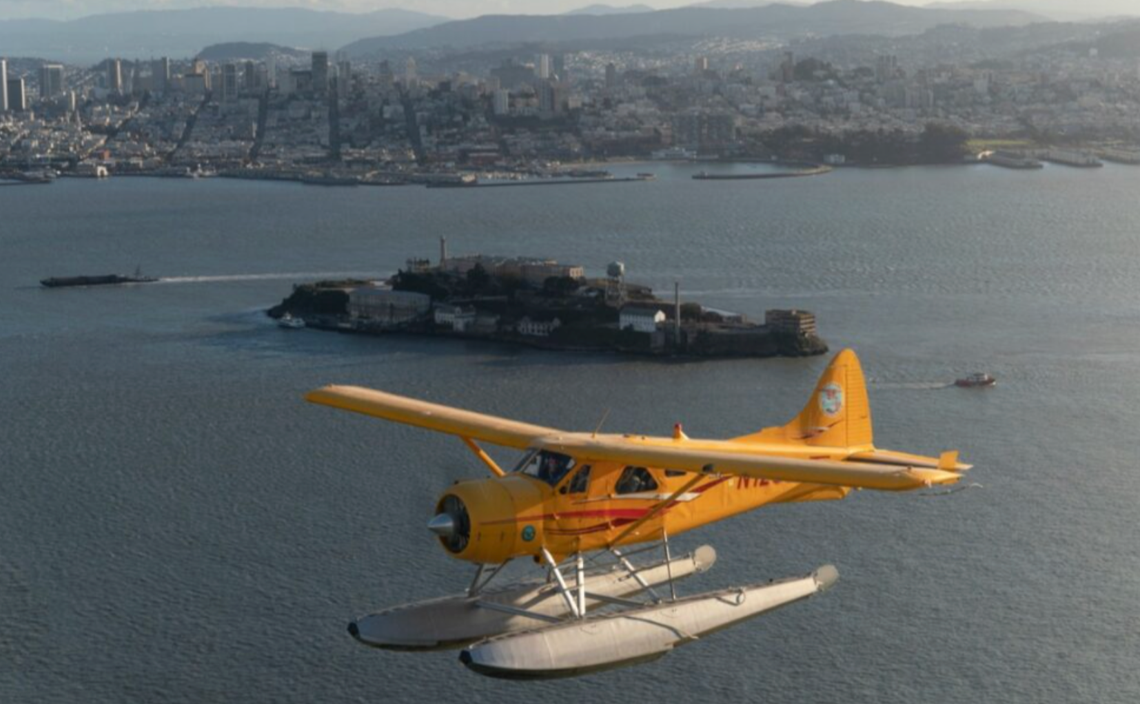
Richmond occupies a particular edge of the Bay Area: industrial waterfronts, long causeways, tidal marshes, and a skyline punctuated by bridges. For airplane lovers that variety translates to layered experiences. From the air, the Bay’s geometry reads differently—sinuous shorelines become graphic ribbons, bridges stitch neighborhoods together, and the patchwork of wetlands and refinery yards tells a story of industry and habitat working in parallel. That visual contrast is why pilots and photographers alike favor brief sorties over Richmond: you can compress urban, industrial, and natural landscapes into a single flight.

Beyond the visuals, Richmond’s access to nearby airports and flying routes makes it a pragmatic hub. General aviation fields and seaplane activity around the Bay mean a range of options exists for different comfort levels—introductory discovery flights, scenic bay tours, flight training, and aerial photography charters. For the traveler who wants to sample flight without committing to pilot training, short sightseeing flights give the visceral lift of altitude combined with the immediacy of local stories: naval history along the Richmond Shipyards, the arc of the Bay Bridge in the distance, and the seasonal moods of the marine layer.

This guide centers on the airplane experience specifically: how to plan a flight out of the Richmond area, where to watch and photograph aircraft from shore, what seasonal weather you’ll face, and how to pair an aerial outing with complementary activities like bay kayaking, coastal cycling, or visiting historic Point Richmond. It’s written for curious travelers—families looking for a memorable outing, photographers after a new vantage, and aspiring pilots weighing their first lesson. Practical details are foregrounded, but the prose keeps that magazine-silver lining: you should leave knowing how to book, how to pack, and what to expect when you climb through Richmond’s strip of sky.

Richmond’s shoreline viewing spots and nearby airports make it easy to stitch together a half-day of airborne exploration and on-the-ground leisure—arrive early for soft morning light, or book a late-afternoon flight to catch the golden hour over the Bay.

Maritime weather dominates planning here. Coastal fog, known locally as the marine layer, can obscure visibility in summer mornings and sometimes returns by evening; the clearest flying windows often appear in late summer and early fall.

Complementary activities are close at hand: pair a scenic flight with a waterfront walk in Point Richmond, a kayak trip in the estuary, or a shoreline picnic at the Richmond Marina to extend the day’s perspective from sea level to sky.

Activity focus: Scenic flights, flight training, aerial photography, and plane spotting
Total matching airplane experiences in the region: 18
Best views: Bay bridges, shipyards, marshes, and the industrial waterfront
Weather factor: Marine layer and bay winds influence visibility and scheduling
Access: Ground transport and parking are straightforward; nearby major airports expand flight options

Best Time to Visit

Best Months

MayJuneSeptemberOctober

Weather Notes

Expect a marine layer that often forms overnight and burns off mid-morning during warmer months. Late summer and early fall usually provide the clearest skies and calmest conditions for photography and sightseeing flights. Winter and spring bring more low clouds and occasional rain—dramatic skies for moody aerial imagery but more frequent delays.

Peak Season

Late summer and early fall for clearer visibility and stable flying conditions.

Off-Season Opportunities

Winter can offer lower traffic and striking cloudscapes; pilots and operators often have greater scheduling flexibility midweek.

Frequently Asked Questions

Do I need any permits to take a scenic flight over Richmond?

Most short scenic flights are arranged through licensed operators and do not require additional permits for passengers. Operators coordinate any necessary clearances. If you plan drone photography from shore or a nearby marsh, check local regulations and permits separately.

Are flights safe for children and older travelers?

Yes—many operators accommodate families and older passengers, but check weight, health, and seating restrictions in advance. Inform the operator of any mobility concerns so they can advise on boarding and seating arrangements.

What's the best way to photograph bridges and the waterfront from an airplane?

Book a flight that specifically includes Bay flyovers and request a window on the side facing the shoreline. Morning light after the marine layer burns off or late afternoon golden hour produces the most flattering contrasts; communicate photographic goals to your pilot before takeoff.

Choose Your Experience Level

Beginner

Ideal for first-time flyers and families—short discovery flights and on-the-ground plane spotting that require no prior experience.

  • 30–45 minute scenic bay tour
  • Shoreline plane-spotting at Richmond Marina or Point Richmond
  • Introductory flight lesson (first hour) to experience controls with an instructor

Intermediate

For travelers comfortable flying and seeking a more tailored experience—longer aerial photography sorties or multiple-leg flights around the Bay.

  • Custom aerial photography flight
  • Extended sightseeing loops including San Francisco Bay bridges and wetlands
  • Discovery flights combined with a local aviation museum visit (self-guided)

Advanced

For pilots or experienced aviation enthusiasts looking for deeper engagement—flight training, cross-country legs, and photography workshops from the air.

  • Flight training blocks and endorsements from local flight schools
  • Multi-stop cross-country flights using nearby general aviation fields
  • Advanced aerial photography mission planning and execution

Insider Tips & Local Knowledge

Coordinate with operators early and stay weather-flexible—Bay conditions change fast.

Book morning flights with a flexible return window for better odds of seeing the Bay after the marine layer lifts; if you must fly through foggy mornings, plan for later alternatives. Tell your pilot your photographic goals—their route choices and altitudes can make or break a shot. For shore-based plane spotting, low tide reveals more shoreline contrast and reflections; parking at Point Richmond or the marina gives multiple viewing angles. If you’re combining an aerial outing with ground activities, leave at least an hour between scheduled flights and ground plans to accommodate minor delays. Finally, for aspiring pilots, book a discovery lesson on a weekday to get more instructor attention and avoid weekend airfield congestion.

What to Bring

Essential

  • Valid government-issued photo ID (required for many flights and airfields)
  • Camera with fast lens or smartphone with good stabilization
  • Layered clothing—bay mornings and evenings are cool even in summer
  • Sunscreen and sunglasses for open-cockpit or low-sun flights
  • Ear protection (some operators provide, but bring a lightweight pair)

Recommended

  • Light backpack to keep gear organized during shore-side spotting
  • Motion-sickness medication if you’re prone to airsickness
  • Portable charger for phone and camera
  • List of landmarks you want to photograph or see from the air

Optional

  • Binoculars for long-distance plane spotting from shore
  • Notepad or voice recorder for logging flight details
  • Compact weather app or aviation-weather briefing screenshot

Ready for Your Airplane Adventure?

Browse 18 verified trips in Richmond with instant booking

Explore Top 15 Richmond, California Adventures →