Navigating Utah's Scenic Waterways and Meeting Points: A Practical Guide
Utah’s scenic waterways offer more than beautiful views—they present an active challenge with dynamic currents and essential logistics for access. This guide helps hikers and paddlers find the best meeting points and navigate local water access with practical tips for timing, terrain, and hydration.
Arrive Early to Avoid Crowds
Popular water access points fill quickly, especially on weekends and summer holidays. Plan your meet-up before 8 AM for the best parking and quieter trails.
Wear Water-Resistant Footwear
Accessing waterways often means wet, uneven ground. Footwear with good grip and water resistance prevents slips and protects your feet during creek crossings.
Bring Ample Water and Know Refill Spots
Water sources are scarce along desert trails. Carry a minimum of 3 liters and study maps for refill stations near major access points like Lee’s Ferry or Sand Hollow.
Check Seasonal Flow Rates
Spring water flows can be fast and dangerous while summer currents slow. Understand river conditions before paddling or wading to match your skill level.
Navigating Utah's Scenic Waterways and Meeting Points: A Practical Guide

Just The Two of US
All Ages! • Half & Full Day Options • Trip for 1 Person
Looking for a peaceful fishing experience in Colorado? Discover how Kindred Anglers LLC offers personalized, instruction-rich half-day trips on Dacono’s best waters, perfect for all skill levels.
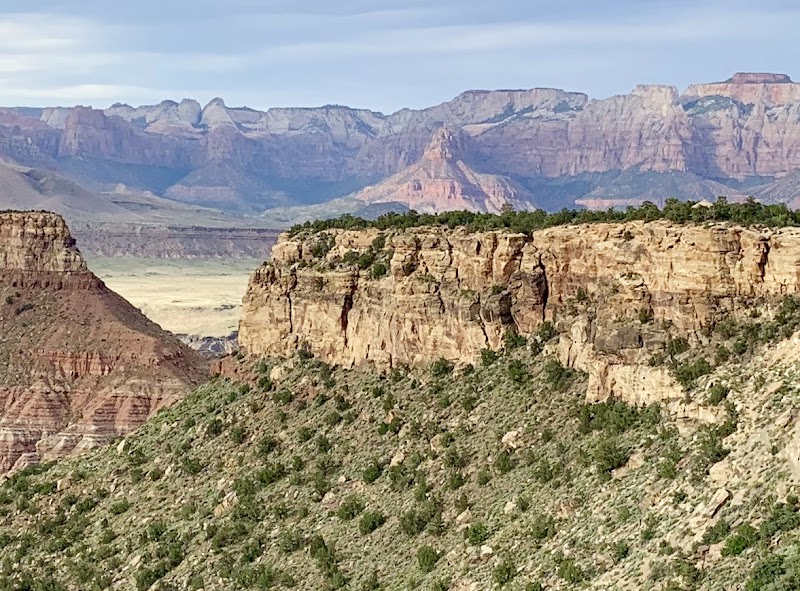
Utah’s scenic landscapes are framed not only by red rock cliffs and sweeping desert vistas but by a network of dynamic waterways and essential meeting points that every adventurer should understand. From the roaring Colorado River to the quieter tributaries threading through canyons, these waters refuse to be mere backdrops—they dare you to find rhythm with their flow. Planning your hike or paddle requires more than just knowing where to start; it demands thoughtful navigation of access points, timing, and terrain to truly engage with the fierce, shifting pulse of the land.
Start your journey by choosing your meeting point carefully. Popular access sites such as Lee's Ferry near Page, AZ, for the Colorado River, or the Sand Hollow Reservoir boat launches south of St. George, offer well-marked parking and easy water entry. However, crowds swell in peak seasons. To avoid congestion, arrive early or consider less trodden points like the Escalante River access near Lower Calf Creek. These spots require a bit more legwork—expect gravel roads and a short trek to the water’s edge—but the payoff is proximity to serene waters and fewer fellow adventurers.
Distances along Utah’s water routes vary. For instance, paddling the Colorado through Horseshoe Bend covers roughly 3 miles with moderate currents pushing you forward, an ideal introduction to river navigation. Conversely, hiking along streams like the Virgin River Trail near Zion demands alert footing on uneven, sometimes slick terrain, with elevation gains modest but enough to challenge casual hikers. Footwear should offer solid grip and protect from submerged rocks, while water-resistant bags safeguard essentials.
Hydration here is critical. The dry air will drain your reserves quickly, especially when sun exposes the land unapologetically. Carry at least 3 liters of water per individual for moderate hikes and more if you plan on extended river activities. Water access points double as hydration hubs—many feature filtered taps or designated refill stations, but these are scattered, so plan accordingly.
Timing your access to water also means reading the seasons. Springwaters pulse stronger from mountain snowmelt, quickening currents and swelling rivers; they command respect and cautious navigation. Summer's heat exposes the stark desert beauty but demands early starts to beat the midday sun. Early fall offers cooler temps and vibrant foliage framing the waterways, perfect for photographers. And winter? Wildlife footprints pattern frozen shores, but water access points may be icy or closed.
In every local waterway, there is a dialogue between you and the element. Currents ferry you forward or test your effort; riverbanks beckon with forested alcoves or expose cliffs that catch sunsets with a fierce glow. Respect these forces. Know your meeting points, prepare for shifting terrain, and approach Utah’s water access not as a passive visitor but an engaged participant in a landscape that is intensely, unapologetically itself.
Nearby Trips
All Adventures
Boat Charters
Water Activities
Adventures near St. George
Discover the unique and memorable adventures that make St. George special.
Frequently Asked Questions
Are water access points wheelchair accessible?
Most river and lake access points in Utah's scenic areas vary. Some major spots like parts of Sand Hollow Reservoir have ADA-compliant facilities, but many trails leading to water are rugged and not suitable for wheelchairs. Check specific access sites in advance.
What wildlife might I encounter near Utah’s watercourses?
Expect to see mule deer and river otters along waterways, and bird species including great blue herons and peregrine falcons. Wildlife tends to be more active in early morning or dusk, often skirting quietly on the riverbank.
Is it safe to drink from rivers or streams?
No. Despite the clear waters, natural contaminants exist. Carry a reliable filtration system or purify water before drinking if you must source it along the trail.
How do I know if river currents are safe for paddling?
Check local water gauge reports from the U.S. Geological Survey or ranger stations. Spring runoff typically creates fast-flowing conditions better suited for experienced paddlers.
Are permits required for accessing certain water areas?
Some areas, especially those managed by the National Park Service (such as sections of the Colorado River through Glen Canyon), require permits or fees. Research ahead depending on your planned route.
What is the best way to avoid overcrowding at popular meeting points?
Visit early in the morning on weekdays, or opt for less popular access points like smaller tributaries or unofficial trailheads. Timing and location are key to finding solitude.
Recommended Gear
Sturdy Hiking Shoes with Grip
Protects feet over rocky and wet trails around water access points; crucial for safe footing.
Hydration Pack or Water Bottles
Ensures ample water supply in mostly dry environments; refill at designated stations when possible.
Lightweight Waterproof Jacket
Keeps you dry during unexpected spring rains or river spray during paddling activities.
Sun Protection (hat, sunscreen)
Necessary year-round to guard against intense UV, especially near reflective water surfaces.
Local Insights
Hidden Gems
- "Cathedral Wash near Zion offers a quiet river-adjacent hike with fewer visitors"
- "Echo Canyon near St. George has secluded watering holes great for dips and rest"
Wildlife
- "River otters in the Virgin River"
- "Desert bighorn sheep often descend near water during dawn"
History
"Many Utah waterways have historical significance as routes used by Native American tribes and early settlers. Lee’s Ferry, for instance, was a key crossing of the Colorado River in the late 19th century."