Mastering Trail Maps and Route Planning in Tahoe’s Mountain Terrain
Navigating Tahoe’s diverse mountain trails starts with the right map and a solid plan. Learn how to choose detailed maps, anticipate terrain shifts, and plot routes that match your pace and skills, ensuring a safe and exhilarating hike.
Carry Both Digital and Paper Maps
Digital apps offer real-time GPS tracking but can lose signal; always have a paper map as backup to stay oriented in Tahoe’s rugged terrain.
Check Elevation Gains Carefully
Review contour lines to estimate physical demands; steep climbs require more time and energy, so plan breaks accordingly.
Start Early to Avoid Afternoon Storms
Storms are frequent in afternoon hours, especially summer; begin hikes at dawn to maximize daylight and safer weather windows.
Hydrate and Pack Filtration Gear
Water sources can be scarce or seasonal; carry enough water and a reliable filtration system for backcountry safety.
Mastering Trail Maps and Route Planning in Tahoe’s Mountain Terrain

E- Mountain Bikes - 7 Day Rentals
Starting at $700 | Medium - Large
Explore Truckee's stunning mountain trails effortlessly with a 7-day E-Mountain Bike rental from Bike Truckee. Discover scenic vistas, challenging climbs, and unforgettable outdoor adventures at your own pace.
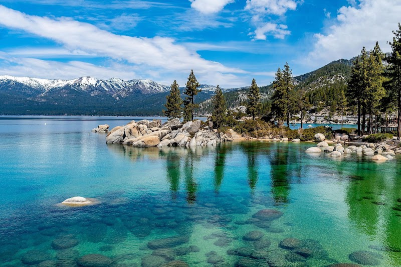
Tahoe’s rugged mountain terrain demands respect and preparation, starting with choosing the right trail map. Here, the mountains don’t just rise—they challenge and invite, pushing you forward through dense pine forests where the air plays cool and fresh. The first step into this wilderness is understanding the lay of the land—not just through eyes but through careful planning.
When selecting a trail map, prioritize detail and scale. Tahoe’s mountain trails vary from gentle forest paths to steep ridgelines climbing over 3,000 feet of elevation gain. Topographic maps revealing contour lines help you read the gradient and predict where the trail will test your stamina. Digital maps like Gaia GPS or AllTrails offer interactivity and updates but always carry a printed version as backup—the mountains may silence your signal at any moment.
Mapping your route means more than plotting start and end points. Identify key waypoints: water sources, shelter spots, and junctions where the trail forks. Pay special attention to trails with mixed terrain—rocky sections that demand sturdy boots and switchbacks that ease ascents but extend mileage. For example, a 7-mile hike around Mount Tallac involves 3,300 feet of elevation gain through sweeping vistas and forested stretches, so plan your pace accordingly.
Timing is crucial. Begin hikes early to avoid afternoon thunderstorms that often sweep in from the Sierra crest. Hydrate well and carry at least two liters of water, with filtration gear if possible. The trail’s mood shifts with the sun; morning light dances on aspen leaves, while dusk persuades shadows to lengthen and the temperature to drop swiftly. Footwear matters here: trail runners suffice on packed dirt paths, but on rugged or snowy stretches, hiking boots with ankle support prevent injury.
Stay flexible. Tahoe’s landscape is fiercely itself—weather can turn sharp, and the trail’s character can switch from whispering pine groves to exposed ridgelines offering panoramas of glimmering lakes and sheer granite. Respect the environment and your limits, adjusting your route if conditions demand. Planning isn’t about conquering but about aligning your steps with the mountain’s rhythm.
In the end, an informed map and well-thought-out route become your allies, making Tahoe’s formidable terrain accessible and rewarding. You won’t just walk the paths—you’ll engage in a dialogue with the land, where every turn asks for attention, every climb tests endurance, and every clearing offers a moment to breathe in the height of adventure.
Nearby Trips
All Adventures
Boat Charters
Water Activities
Adventures near South Lake Tahoe
Discover the unique and memorable adventures that make South Lake Tahoe special.
Frequently Asked Questions
How do I choose between digital maps and printed maps for Tahoe hikes?
Digital maps give real-time location updates and route tracking but rely on battery life and cell signal, which can be scarce in Tahoe’s mountains. Printed maps, especially detailed topographic ones, are reliable backups and crucial for understanding elevation and terrain when technology fails.
What are some lesser-known viewpoints in Tahoe’s trail system?
Beyond popular spots like Emerald Bay, try the waterfall vista on the Van Sickle Bi-State Trail or the quieter overlook near the Spooner Summit. These provide sweeping lake views without the usual crowds.
What wildlife should hikers be aware of on Tahoe’s mountain trails?
Expect to encounter mule deer, black bears, and the occasional mountain lion. Birdlife includes Steller’s jays and Clark’s nutcrackers. Always store food securely and maintain respectful distance from wildlife.
Are there any historical sites accessible on Tahoe’s hiking routes?
Yes, Tahoe’s trails intersect with remnants of mining camps and old logging roads, with interpretive signs at places like the Flume Trail detailing the area’s resource extraction history.
What environmental considerations should hikers keep in mind while planning routes?
Tahoe’s ecosystem is sensitive—stay on designated trails to prevent erosion, pack out all waste, and be mindful during fire season when restrictions may apply. Avoid disturbing fragile alpine vegetation.
When is the best time of day for photography on Tahoe trails?
Early morning and late afternoon offer soft, directional light that accentuates texture and depth, perfect for capturing rugged landscapes and wildlife activity.
Recommended Gear
Topographic Trail Map (Printed)
Essential for understanding elevation changes and key terrain features in Tahoe’s varied mountain landscape.
Hydration System with Filter
Keeps you hydrated and allows safe water refills from streams, critical during longer summer hikes.
Sturdy Hiking Boots
Provides ankle support and traction on loose rocks and uneven ground typical in Tahoe.
Layered Clothing
Adjust for temperature swings—from warm sunbaked trails to cool, shadowed forest patches.
Local Insights
Hidden Gems
- "Van Sickle Bi-State Trail’s waterfall viewpoint"
- "Spooner Summit overlook"
- "Hidden meadows along the Tahoe Rim Trail"
- "Quiet corners of Fallen Leaf Lake"
Wildlife
- "Mule deer that graze near trail edges"
- "Black bears crossing high ridge lines"
- "Highland grouse and varied songbirds"
- "Mountain lions (rare, cautious observation needed)"
History
"The Tahoe area’s hiking trails cross ground of historic mining and logging operations dating back to the late 1800s. These routes reveal the interaction between natural resources and human settlement patterns shaping the region."