Essential Landmarks to Spot During Your Helicopter Flight Over Salt Lake City
Experience Salt Lake City from a thrilling new perspective—above its iconic landmarks, natural wonders, and rugged mountains. This guide reveals key points to spot during your helicopter flight, with tips to help you turn panoramic views into your next outdoor adventure.
Schedule Flights for Optimal Visibility
Plan your helicopter ride for late morning to early afternoon when sun angles reduce glare off the Great Salt Lake and city reflections are crisp.
Bring a Camera with a Polarizing Filter
A polarizing filter reduces reflections on water and glass surfaces, ensuring your photos capture the true colors of Salt Lake City's landmarks.
Dress in Layers for Variable Temperatures
At altitude, temperatures drop; wearing layers ensures comfort whether you experience wind chill or sunlit warmth in the cabin.
Listen Closely to Your Pilot's Guidance
Pilots provide crucial insights about landmarks and safety; attentive listening enhances your experience and safety during unexpected maneuvers.
Essential Landmarks to Spot During Your Helicopter Flight Over Salt Lake City

Mountainside Salt lake City Tour
All Ages • 30 Minute Tour • Up to 4 Passengers • $269 per Person
Discover Utah's stunning landscape on the Mountainside Salt Lake City Tour, a guided helicopter experience that offers unmatched views of salt flats, mountains, and scenic valleys. Perfect for adventure seekers and photography lovers alike.
Flying above Salt Lake City offers a unique vantage point on a city that wears its geography and history with clarity and force. From the rotors of your helicopter, the sprawling urban grid blends crisply into the base of the Wasatch Range. Your flight begins over the downtown core where the sharp angles of the Utah State Capitol resist the sky, commanding attention with its neoclassical dome. This landmark isn’t just a seat of government; it strategically perches on Capitol Hill, giving you a striking downward view of Temple Square with its gleaming spires and manicured gardens. Watch the currents of the Jordan River as it carves through the valley floor, its waters daring you to imagine the ancient pathways and modern trails it nourishes.
Moving east, the Great Salt Lake jumps into view, a vast, reflective expanse where the horizon seems to dissolve into salt flats. Its shimmering surface changes with the wind—sometimes glassy, other times restless as gusts push waves gently against curving shorelines. Keep an eye out for Antelope Island, a rugged patch of land punctuated by rolling hills and home to bison herds that roam freely. The island’s isolation is tangible even from above, a quieter contrast to the urban sprawl below.
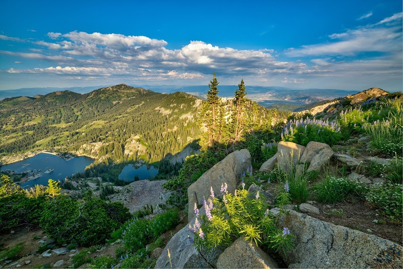
Toward the north, the Wasatch Mountains rise sharply, their ridges jagged and fiercely themselves, wearing snow well into spring. The aerial perspective highlights the patchwork of ski resorts and hiking trails that lace the slopes. Peaks like Mount Olympus throw shadows over deep forested canyons, where rivers hurry and creeks trickle, challenging explorers with steep climbs and rewarding views.
A helicopter flight isn’t just a sightseeing tour; it’s a practical way to orient yourself in a landscape that demands respect and preparation. Spotting landmarks from above helps you identify potential trailheads, urban access points, and natural features to plan your next adventure on foot. To make the most of your trip, plan your flight during midday for the sharpest clarity or near sunset to watch shadows stretch across the rugged terrain. Keep your camera ready—the shifting light can reveal details that guidebooks can’t.
Whether tracking the course of the Jordan River, identifying the grid lines of downtown, or marveling at the silent expanse of the Great Salt Lake, this aerial journey strikes a balance between exhilarating views and grounded insights, offering both the thrill of discovery and a clearer blueprint for exploration.
Nearby Trips
All Adventures
Boat Charters
Water Activities
Adventures near Salt Lake City
Discover the unique and memorable adventures that make Salt Lake City special.
Frequently Asked Questions
What is the best altitude to spot Salt Lake City's landmarks during the flight?
Helicopters typically fly between 1,000 to 2,500 feet above ground level during tours. This altitude balances proximity for detail and safety for smooth flight, allowing views of landmarks like the Utah State Capitol and Great Salt Lake with clarity.
Are there lesser-known viewpoints visible from the helicopter?
Yes, areas like the Red Butte Garden and the hidden Swaner Preserve stand out from above for their subtle contrasts in greenery and water channels—often missed when on the ground.
Can wildlife be seen from the helicopter flight?
Antelope Island offers views of bison herds, and depending on the season, you might spot migrating birds near the Great Salt Lake’s wetlands, including pelicans and shorebirds.
What is the historical significance of landmarks visible during the flight?
Temple Square dates back to early Mormon settlement in the 1800s and remains a cultural heart of the city. The Utah State Capitol, completed in 1916, anchors the city's governance and reflects classical architectural traditions.
Are there any environmental precautions to keep in mind during helicopter flights?
Operators follow strict guidelines to minimize noise pollution and disturbance to wildlife, especially around sensitive habitats like wetlands and Antelope Island.
What photography opportunities are best during the flight?
Early morning or late afternoon flights maximize warm light, creating long shadows over urban and natural landscapes. Focus on contrasts between the city grid, mountain ridges, and water surfaces for compelling shots.
Recommended Gear
Camera with Zoom Lens
Captures detailed views of landmarks and natural features not easily seen with the naked eye.
Windbreaker or Light Jacket
Protects against chilly winds at altitude and varying temperatures inside the helicopter.
Polarizing Sunglasses
Reduces glare from reflective surfaces like water and windows, enhancing visibility.
Closed-toe Comfortable Shoes
Appropriate for airport and heliport terrain, providing stability when boarding and disembarking.
Local Insights
Hidden Gems
- "The Crystal Springs area offers quiet forests and less trafficked streams seen glimmering from above."
- "The Gilgal Sculpture Garden, a small but intriguing public art space nestled near downtown, is distinct in shape from the air."
- "Twin Peaks provides dramatic ridgeline views and is lightly known to many visitors."
Wildlife
- "Bison herds roam Antelope Island with surprising ease, their movements visible even from hundreds of feet in the air."
- "Common birds include California gulls near the lake and peregrine falcons nesting in the cliffs of the Wasatch Range."
History
"Salt Lake City’s layout reflects its planned origins by Mormon pioneers in the 1840s, with a grid system that respects the surrounding mountains and waterways as both natural boundaries and sources of irrigation."