Mastering Timing for Brown’s Canyon Class III Drops: When to Navigate the Rapids Safely
Brown’s Canyon’s class III drops demand precise timing to navigate safely. From the roaring spring floods to the gentler summer flows, understanding the river’s seasonal rhythm ensures a thrilling yet controlled experience. Learn when and how to tackle these rapid sections for your best run.
Check River Levels Before Launch
Monitor the Arkansas River gauge near Salida to understand flow rates—moderate levels offer ideal conditions for navigating class III drops safely.
Start Early for Calm Conditions
Mornings generally bring smoother water and lighter winds, allowing better visibility and control on the rapids.
Pack Protective Footwear
Wear neoprene river shoes with good traction to shield feet from submerged rocks during portages or unexpected exits.
Stay Hydrated and Energized
Bring a hydration pack and salty snacks. The cold, dry air saps fluid, and adrenaline speeds up dehydration on the water.
Mastering Timing for Brown’s Canyon Class III Drops: When to Navigate the Rapids Safely

Inflatable Kayak: Upper Brown’s Canyon 9am-3pm
Ages 14 & Up | Class III+ | Intermediate/Advanced
Paddle through Class III rapids amid towering granite cliffs on a thrilling kayak trip in Brown’s Canyon National Monument, Colorado’s premier whitewater destination.
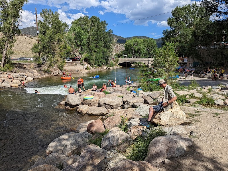
Brown’s Canyon cuts a fierce path through Colorado’s rugged terrain, with its class III drops challenging paddlers to read the river’s mood carefully. Timing here is everything. The drops roar louder in springtime, when snowmelt swells the Arkansas River, pushing you through tight rocky slots and waves that dare you to hold your ground. By summer, water levels ease, offering a less intimidating but still thrilling ride where quick reflexes remain essential.
Planning your run means syncing your adventure to the river’s pulse. Early morning launches can catch the water at its coolest, calmer stretch, allowing better control and quicker recovery between drops. Avoid late afternoon when winds whip up and currents grow unpredictable. Keep an eye on recent weather—rain upstream can bulge the river in hours, turning manageable drops into dangerous chutes.
The canyon’s drops are not forgiving. Four significant class III segments between Browns Canyon National Monument and the town of Salida span roughly 7 miles. Elevation ranges around 7,000 feet, and the terrain onshore shifts from dense Ponderosa pine groves to exposed granite cliffs, providing natural rest points but few places to scramble easily if you’re caught off guard.
Footwear matters here. Neoprene river shoes with sturdy soles protect feet from sharp rocks while offering traction for quick exits. Hydration is key—dry mountain air and adrenalized paddling consume electrolytes fast. Bring a compact hydration system, and plan periodic breaks where the river calms enough for safe wading or landing.
Respect the river’s character. It will test how well you read its currents and drops, rewarding those who approach with steady preparation and humility. Each rapid is a conversation — timing your approach to the drops during moderate flows lets the water guide your craft instead of fighting it. With vigilance, you’ll find the balance between control and surrender, where the true adventure lies.
Nearby Trips
All Adventures
Boat Charters
Water Activities
Adventures near Salida
Discover the unique and memorable adventures that make Salida special.
Frequently Asked Questions
What river flow rates are best for safely navigating Brown’s Canyon class III drops?
Ideal flows typically range between 1,500 and 2,500 cubic feet per second. Below this, rapids may be too shallow; above it, river currents can become dangerously powerful and unpredictable.
Can beginners run the class III drops in Brown’s Canyon?
While some experienced intermediate paddlers may attempt these drops with a guide, true beginners should build skills on easier whitewater before tackling Brown’s Canyon’s technical rapids.
Are there good launch points with easy access nearby?
Yes, Cottonwood Lakes and McCabe Gulch provide accessible put-in spots, with parking and facilities. These points align well with manageable distances between rapid sections.
What wildlife might I see along the riverbanks?
Keep an eye out for river otters, great blue herons, and mule deer, all of which actively use the riparian corridor. Early mornings increase wildlife sightings.
Is there cellphone coverage in Brown’s Canyon?
Coverage is spotty and often unavailable in deeper canyon stretches, so prepare accordingly, especially for emergencies.
Are group permits required for river rafting here?
Brown’s Canyon National Monument requires permits for commercial groups, but private recreational use usually does not. Check the latest rules with the National Park Service before launching.
Recommended Gear
Hydration Pack
Keeps you hydrated during intense bursts of activity and dry mountain air conditions.
Neoprene River Shoes
Protects feet from jagged rocks and provides grip on slippery shores.
Helmet and Personal Flotation Device (PFD)
Essential safety gear to protect against impact and keep you buoyant in flowing water.
Waterproof Map or GPS Device
Helps navigate portages and river access points along the canyon.
Local Insights
Hidden Gems
- "Granite Point Overlook—provides a rarely visited panoramic view of the river’s twisting course."
- "Sunset Rock—ideal spot to catch golden light illuminating the canyon walls."
Wildlife
- "River otters play near calm eddies."
- "Bald eagles glide overhead during spring migration."
History
"The canyon holds artifacts from early Ute tribes and saw mining activity in the late 1800s, now preserved within the National Monument boundaries."