Timing and Trail Conditions: Planning a Seamless Trip on Mount Tamalpais, California
Mount Tamalpais State Park is a dynamic blend of rugged trails and sweeping coastal views that demand both respect and readiness. Discover how understanding seasonal patterns and trail conditions can help you craft an adventure that flows effortlessly through Northern California’s wild terrain.
Start Early in Summer
Begin hikes before 8 a.m. to avoid midday heat and maximize cooler trail conditions.
Bring Waterproof Footwear in Winter
Trails become slick and muddy; waterproof boots improve grip and comfort.
Carry At Least 2 Liters of Water
The dry summer air and steady climbs demand hydration; lack of water can turn a hike hazardous.
Use Trail Maps and Check Recent Conditions
Weather shifts and maintenance closures can affect trail access—verify before heading out.
Timing and Trail Conditions: Planning a Seamless Trip on Mount Tamalpais, California

Trail Tracker
Explore the stunning scenery of Fernandina Beach on an electric bike rental. Perfect for discovering local sights, wildlife, and hidden secrets on Amelia Island’s scenic trails and historic streets.
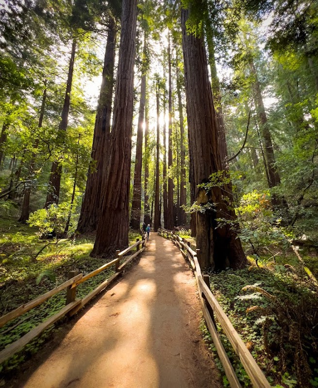
Mount Tamalpais State Park in California offers a rare balance of invigorating trail experiences combined with practical accessibility. The timing of your visit and awareness of trail conditions are key to turning a simple hike into an unforgettably smooth outing. Stretching across roughly 25 miles of trails, with elevation gains up to 2,500 feet, the terrain challenges both casual walkers and seasoned hikers with a mix of packed dirt paths, rocky sections, and occasional steep climbs.
Spring and fall present the most favorable trail conditions, when the forest wakes with fresh greenery and wildflowers invite short pauses for admiration. The trails ride a calming rhythm under towering redwoods, while slopes open up to sharp views where the Pacific Ocean dares to whisper in the distance. Summer heat, however, pushes hikers to start early and carry ample water—hydration here is as crucial as steady footing on rocky switchbacks.
Winter months bring soggy earth and slick rocks, demanding sturdy waterproof footwear and perhaps trekking poles for balance. Some trails near the peak become too treacherous after rain, so checking recent trail reports is a must. The park’s weather is fiercely changeable; fog can roll in suddenly, veiling views and adding a mystical chill to the air.
To plan seamlessly, consider the trail's workload: the Dipsea Trail, one of the most popular routes, covers approximately 7 miles with a 2,200-foot elevation gain, weaving through dense forest and opening to panoramic ridges. Whether you’re seeking a half-day jaunt or a full-day adventure, timing your hike to avoid the busiest midday hours ensures a quieter, more immersive experience.
Keep your gear lean but effective: high-traction hiking boots, layered clothing adaptable to shifts in temperature, and plenty of water—Mount Tam’s dry summer winds will test your endurance. Trail maps and recent weather forecasts safeguard against surprises that can make or break your day.
In essence, respecting Mount Tamalpais’ seasons and trail moods means preparing like you’re meeting an old friend who’s fiercely herself—sometimes serene, sometimes wild. The mountain won't hesitate to remind you of its rhythm. Align your time on the trails with its pulse, and it will reward with not just views, but a seamless, invigorating adventure carved deep into Northern California’s coastal wilderness.
Nearby Trips
All Adventures
Boat Charters
Water Activities
Adventures near Mill Valley
Discover the unique and memorable adventures that make Mill Valley special.
Frequently Asked Questions
When is the best time to avoid crowds on Mount Tamalpais trails?
Weekdays during spring and fall mornings typically have fewer hikers. Early mornings and late afternoons on weekends are less crowded as well compared to midday.
Are dogs allowed on the trails?
Yes, dogs are permitted but must be kept on leash due to local wildlife and trail safety regulations.
How can I check current trail conditions before hiking?
Visit the Mount Tamalpais State Park website or call the visitor center; local hiking forums also post recent reports.
Does the elevation gain make this hike strenuous?
The 2,200-2,500 foot elevation gain is moderate; pacing yourself and taking breaks will manage fatigue effectively for most hikers.
What wildlife might I encounter?
Birds like Stellar’s jays and red-tailed hawks are common, while black-tailed deer are frequent trail neighbors.
Are there any safety concerns with the weather?
Fog can reduce visibility; sudden temperature drops mean carrying layered clothing and watching trail markers closely is advised.
Recommended Gear
High-traction hiking boots
Provides stability and grip on diverse surfaces, essential year-round.
Layered clothing
Helps adapt to shifting temperatures and foggy conditions typical in fall.
Hydration system or 2+ liters water bottles
Combat dry air and heat; hydration is critical to maintain energy and safety.
Trekking poles
Aid balance on muddy, slippery slopes especially in post-rain or winter months.
Local Insights
Hidden Gems
- "Verna Dunshee Trail for quiet forest immersion"
- "West Point Inn ruins with coastal views"
- "Matt Davis Trail’s looping forest enclaves"
Wildlife
- "Mule deer calmly grazing near trail edges"
- "Coyotes heard in the early evening"
- "Seasonal migrations of hawks and raptors"
History
"The area is rich with Coast Miwok cultural significance and early conservation efforts sparked in the early 1900s to protect the land from urban development."