Mastering Aerial Photography Over Yosemite’s Tuolumne Canyon
Discover how to harness Yosemite's Tuolumne Canyon’s dramatic topography for stunning aerial photography. This guide balances practical hiking details with photography techniques, encouraging adventurers to prepare thoroughly and respect the rugged landscape while capturing breathtaking shots.
Arrive Early for Ideal Light
Plan your hike to reach vantage points by sunrise or late afternoon to best capture the canyon’s textures and contrasts.
Check Local Drone Regulations
Yosemite National Park prohibits drone flights without permits—consider launching outside park boundaries to stay compliant.
Pack Enough Water and Snacks
The elevation gain and dry air require staying well-hydrated; bring at least 2 liters per person plus energy-rich snacks.
Use GPS Navigation
Tuolumne’s ridges and valleys can confuse even experienced hikers; a GPS device or app is crucial for safe navigation.
Mastering Aerial Photography Over Yosemite’s Tuolumne Canyon

Sierra Nevada - Yosemite Tour
For all ages! • Up to 3 people • One Hour
Soar over Yosemite's most famed landmarks with a scenic flight above the Sierra Nevada. Perfect for photography and unforgettable vistas, this tour offers a fresh look at the park’s breathtaking beauty from the sky.
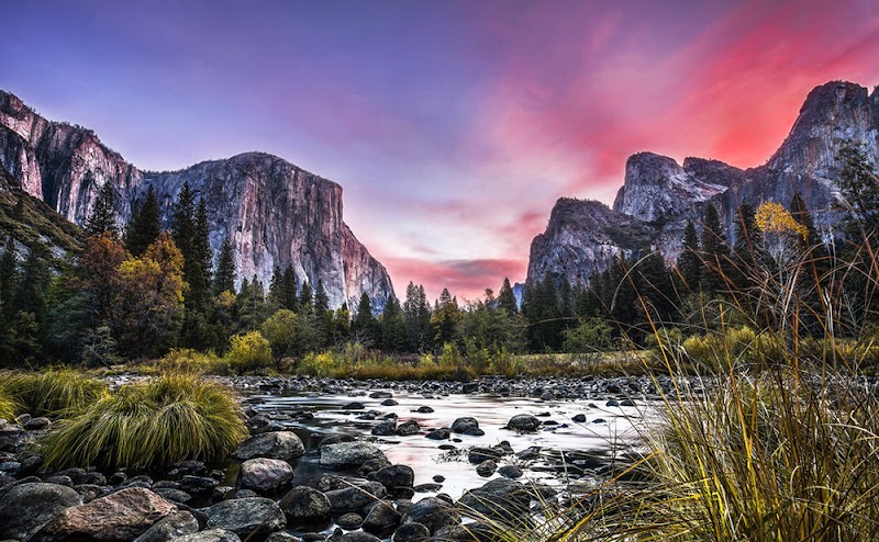
Navigating the rugged heights of Yosemite's Tuolumne Canyon brings a distinct thrill to aerial photography enthusiasts. The canyon’s steep granite walls and winding Tuolumne River carve a scene fiercely itself—inviting you to capture its raw dynamism from above. Reaching launching points for drones or framing shots from ridges requires strategic planning since the terrain pushes both gear and photographer.
Begin your adventure on the Tuolumne Meadows Trailhead. The hike spans approximately 6 miles round trip, with a manageable elevation gain near 900 feet. The path passes through subalpine forests where ponderosa pines reach skyward, their needles brushing the cool air. This climb rewards you with panoramic vantage points where the river dares to curve sharply—a perfect subject for sweeping aerial shots.
Timing is everything. Early morning light softens the rugged outlines, while late afternoon’s golden hour ignites granite faces with warm hues. Avoid midday for aerial shoots; bright light can flatten textures and increase glare. If you operate a drone, understand local regulations: Yosemite National Park restricts drone use without permits. Consider launching just outside park boundaries for legal aerial captures.
Gear up practically. Opt for sturdy hiking boots to negotiate loose rocks and uneven trails, and carry ample water—Tuolumne’s forested stretches mask exertion. A lightweight, weather-sealed drone and adjustable camera lenses enhance flexibility in this environment that offers both sweeping vistas and detailed close-ups. Bring polarized filters to reduce river surface reflections and improve clarity.
To maximize shots, carry a GPS app or device; the canyon’s ridges and drops can disorient without clear navigation. Position your drone or camera from ridgelines overlooking Tuolumne’s sharp bends, or soar above the river to catch sunrays cutting through morning mist. Patience pays here; waiting for cloud patterns to shift or winds to settle refines image quality.
Respect the canyon’s fierce presence. The river’s current pushes the landscape forward, telling a story of slow but unstoppable erosion. The granite cliffs watch stoically, guardians of this wild lab. Move with intention and leave no trace. Whether you’re a casual hiker or a drone pilot intent on capturing the complex beauty below, Tuolumne Canyon rewards preparation, respect, and an eye tuned to both adventure and technique.
Nearby Trips
All Adventures
Boat Charters
Water Activities
Adventures near Lee Vining
Discover the unique and memorable adventures that make Lee Vining special.
Frequently Asked Questions
Are drones allowed inside Yosemite National Park for aerial photography?
No, Yosemite National Park prohibits drone usage without special permits. To photograph Tuolumne Canyon from the air legally, consider flying drones outside park boundaries or at adjacent National Forest lands.
What is the best vantage point for aerial shots in Tuolumne Canyon?
The ridgelines above the Tuolumne River bends offer expansive views perfect for aerial photography. Popular spots include Moraine Dome and Cathedral Peak areas, accessible by moderate hikes.
What wildlife might I encounter on the trail?
Keep an eye out for mule deer browsing near forest edges, Steller’s jays darting among pines, and if early morning or dusk, possibly black bears passing through lower meadows.
How can I best protect my camera and drone equipment on this hike?
Use padded, water-resistant cases and consider weatherproof covers during shoots. Carry equipment in comfortable backpacks designed for outdoor gear to minimize damage on rough sections.
Is there cell phone coverage for GPS or emergency use?
Cell coverage is intermittent in Tuolumne Canyon, especially in steep sections. Download offline maps beforehand and carry a personal locator beacon or satellite messenger for emergencies.
What environmental considerations should I keep in mind?
Stay on marked trails to prevent erosion and avoid disturbing wildlife. Refrain from flying drones near nesting birds or cliffs. Pack out all trash to maintain the canyon’s wild character.
Recommended Gear
Hiking Boots
Provides ankle support and grip on uneven, rocky terrain.
Weather-sealed Drone
Durable against changing conditions; critical for capturing quality aerial shots safely.
GPS Device or Hiking App
Assists navigation through forested sections and complex terrain.
Polarizing Filter
Reduces river glare and enhances contrast for clearer photographs.
Local Insights
Hidden Gems
- "Unmarked viewpoint near Glen Aulin Trail offers quieter river vistas."
- "Rocky outcrop east of Moraine Dome with fewer visitors and dramatic cliffs."
Wildlife
- "American pika calls echo near talus slopes."
- "Mountain lions occasionally patrol the deeper forests—stay alert."
History
"The Tuolumne area served as a travel corridor for the Miwok people and later was a focus point during early park exploration and trail development in the early 1900s."