Preparing for Aerial Photography Over Lake Wallenpaupack: A Practical Adventure Guide
Lake Wallenpaupack offers aerial photographers a dynamic canvas of water, forest, and light waiting to be captured. This practical guide prepares you to navigate the terrain, weather, and regulations, ensuring your drone adventure combines thrilling shots with responsible flight.
Check Local Drone Regulations
Lake Wallenpaupack has designated drone flight zones and seasonal restrictions; confirm up-to-date rules before flying to avoid fines or disturbances.
Bring Extra Power Supplies
Cold mornings and long flights can drain batteries faster. Carry multiple drone batteries and portable chargers to maximize airtime.
Wear Sturdy, Non-slip Footwear
Access paths include gravel and mossy rocks that can become slippery; solid footwear will keep you steady during your approach and landing.
Plan Your Shoot Around Light Conditions
Early mornings and late afternoons deliver softer lighting and dramatic shadows essential for compelling imagery; mid-day light often flattens the scene.
Preparing for Aerial Photography Over Lake Wallenpaupack: A Practical Adventure Guide
Lake Wallenpaupack Air Tour
Starting at $150 | 35 Minutes | 2 Passenger Minimum | Tour Lake Wallenpaupack from the Air!
Take to the skies over Lake Wallenpaupack on a private air tour with Hop On Air LLC. Discover breathtaking views of Pennsylvania's lakes, forests, and rolling hills in a safe, personalized flight experience. Perfect for adventure seekers and photography lovers alike!
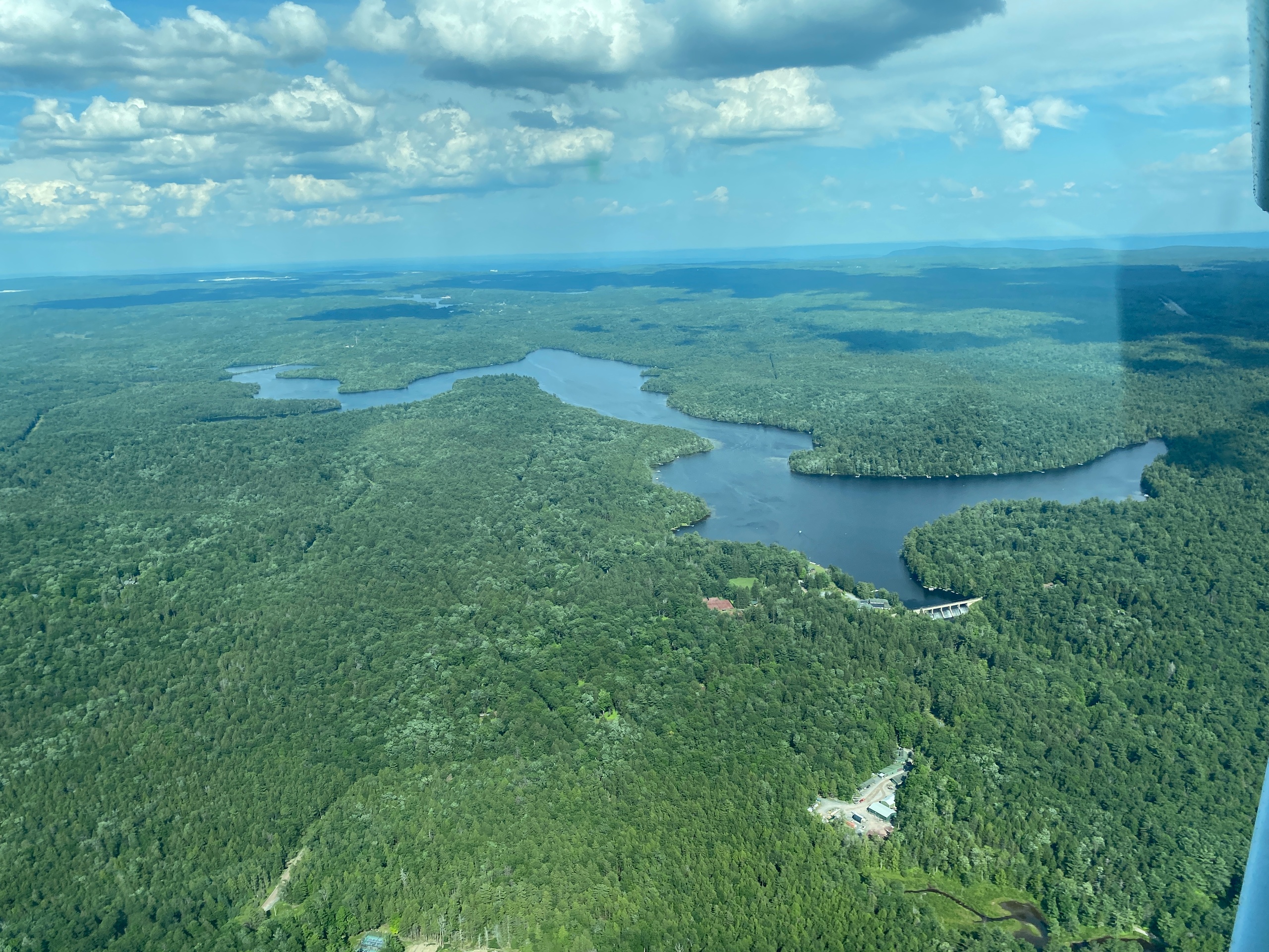
Lake Wallenpaupack cuts a vast, restless figure across northeastern Pennsylvania, daring your drone to lift above its shimmering expanse. This 13-mile-long reservoir stretches between dense forested ridges, offering aerial photographers an opportunity to capture reflections that shift with every breeze and currents that push against the banks with quiet insistence. Preparing for aerial photography here means understanding not just the technical demands but also engaging with a landscape fiercely itself.
Approach from the nearest major access point, such as Paupack Point or Hawley Launch, where parking and takeoff areas are available. The terrain leading up to the shoreline is a mix of gravel paths and forest floor; you’ll traverse approximately half a mile to a suitable elevation for drone launch, with a modest elevation gain of about 100 feet.
The forest along the way doesn’t merely stand still—it leans in, leaves whispering, as you position yourself above a canopy that hums with unseen wings. Consider timing your shoot during early morning or late afternoon, when natural light carves shadows along the water’s edge, and the lake breathes out mist that adds atmosphere to your shots.
Hydration is key. The walk offers little in the way of shade breaks during midday, and the nearby lake, while tempting, isn’t ideal for quick refills unless you bring treatment options. Wear sturdy, waterproof footwear suitable for gravel and occasional slippery moss patches. A wind-resistant jacket is smart; sudden gusts off the water remind you that nature holds the upper hand here.
Respect local regulations. Lake Wallenpaupack falls under specific drone operation rules—stay below 400 feet, avoid no-fly zones near private properties, and always have your FAA registration visible if required. Check for temporary restrictions, especially during wildlife nesting seasons when birds claim the ridges and islands.
Practically speaking, pack a drone with stable hover capabilities and a reliable GPS lock. Extra batteries and memory cards will ensure you don’t cut your flight short. For capturing the most dynamic aerial views, a drone with a gimbal that supports 4K HDR video and RAW photo formats is recommended.
Once in the air, position over the southern stretches to capture the ripple patterns where the lake narrows, or frame the dense forests gripping the hillside as they lean toward the water. Horizon lines offset by rising hills and the faint outlines of boat docks create compelling composition angles.
Wave-ripples turning into glass, sunlight striking leaves like sparks—these moments are yours to seize from above. But beyond the magic of aerial shots, preparation blends respect for the wild pulse of the environment with practical readiness. This isn’t just a shoot; it’s an engagement with a landscape alive and watching, pushing you to rise thoughtfully above it.
Nearby Trips
All Adventures
Boat Charters
Water Activities
Adventures near Hawley
Discover the unique and memorable adventures that make Hawley special.
Frequently Asked Questions
Are drones allowed anywhere on Lake Wallenpaupack?
Drone flights are permitted in designated areas but strictly prohibited near private residences and certain wildlife conservation zones. Always check the latest local drone regulations and temporarily imposed flight restrictions before your visit.
Where can I find less crowded drone launch spots?
Explore the northern and western shores near Island Road and smaller, less obvious boat launches which see fewer visitors but offer stable takeoff terrain and interesting vantage points.
What local wildlife might I capture on aerial footage?
Ospreys and bald eagles are frequent over the lake, especially in spring and summer. Be cautious to maintain distance during nesting seasons to avoid disturbing them.
Is the terrain easy enough for beginners to carry drone gear here?
The paths are moderate—gravel with slight incline. Beginners should proceed carefully with heavier gear and consider going with a partner for safety.
Can I access the lake year-round for aerial shoots?
Access is year-round, but winter ice and snow can make terrain slippery and battery life shorter. Spring rains can also soften trails, so prepare accordingly.
Are there any historical locations nearby that can be included in aerial shots?
The Wallenpaupack area includes historic docks and remnants of old sawmills visible from certain vantage points, adding cultural depth to your images if you explore the shores carefully.
Recommended Gear
Drone with GPS and 4K Camera
Provides stable flight and high-quality imagery necessary for capturing Lake Wallenpaupack’s dynamic landscape.
Extra Drone Batteries
Cold weather reduces battery life; having extras ensures uninterrupted shooting sessions.
Sturdy Hiking Shoes
Essential for safe navigation across gravel and moss-covered trails leading to your launch sites.
Windbreaker Jacket
Protects you from sudden gusts off the lake while offering lightweight warmth during cooler seasons.
Local Insights
Hidden Gems
- "The overlook at Deerfield Road for panoramic lake views"
- "Small inlet near Ledgedale Road for quiet water reflections"
Wildlife
- "Ospreys hunting fish near the lake surface"
- "Great blue herons lingering on shallow edges"
- "White-tailed deer roaming the forest edges"
History
"Lake Wallenpaupack was created in the 1920s as a hydroelectric reservoir, transforming the region's landscape and economy. Relics of old timber industries remain along some shores."