Experience the raw energy of aerial photography flights near Harrison, AR, where rugged Ozark terrain meets dynamic skies. This guide equips you with practical tips and insights to safely and effectively capture the area's stunning landscapes from above.
Map Your Flight Zones Ahead
Review FAA regulations and local flight restrictions before planning your drone path to avoid no-fly zones and protected wildlife areas near Harrison.
Wear Sturdy Hiking Boots
Uneven terrain with rocky and wooded sections demands solid ankle support and grip for your approach hikes to drone launch sites.
Hydrate and Pack Water
Midday humidity and moderate elevation gain call for at least two liters of water to stay properly hydrated during your outdoor preparation and flights.
Plan Flights Around Stable Weather
Morning and late afternoon are ideal due to calm winds and soft lighting; avoid strong winds or thermal turbulence common midday in the Ozarks.
Mastering Aerial Photography Flights Near Harrison, AR: Your Essential Prep Guide

Photography Flight
For all ages! • Max 3 people • 60 minute flights • Combined weight total 550 pounds
Discover the breathtaking beauty of Arkansas from above with a private aerial photography tour. Capture stunning landscapes, wildlife, and scenic views on this exclusive adventure in Marshall. Read on to learn more about this unique experience!
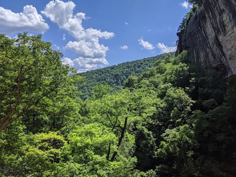
Planning aerial photography flights near Harrison, Arkansas, demands more than just having a drone and pressing record. The rugged landscapes around the Ozark National Forest call for focused preparation that balances technical know-how with an appreciation of the wild terrain beneath your lens. From forested ridges to the White River's daring flow, the area is alive—shaping every flight with its relentless energy.
Start with location specifics. The general flight zones cover mixed terrain ranging from 700 to 1300 feet elevation. Expect moderate elevation changes and dense canopy coverage, especially around East Harrison and the surrounding ridges. Footpaths and access roads can be uneven, with occasional rocky patches, so bring durable footwear and watch your footing as the ground tests your focus.
Timing is key to capture dynamic shots and ensures a safe flight experience. Sunrise and late afternoon offer the best light, as the landscape shifts from golden to shadowed. Mornings bring cool, stable air ideal for drone control, while midday heat can stir unpredictable thermal currents that challenge steady aerial captures.
Packing right means more than batteries and lenses. Keep hydration accessible: the Ozarks currently see moderate humidity, so a minimum of two liters per person for a few hours outside balances comfort and endurance. A lightweight windbreaker helps with changing conditions near higher ridges, where breezes can tighten unexpectedly.
Flight safety requires respecting local regulations and the environment. The Harrison area falls under FAA drone rules, with certain no-fly zones near airports and protected wildlife zones, especially during nesting season. Familiarize yourself with temporary flight restrictions and always check local signage.
Once airborne, anticipate that nature is not a passive backdrop. The White River dares you to synch your shots with its persistent current, while the pines and oaks sway with a deliberate rhythm that will test your aerial steadiness. Each gust pushes and pulls, so mastering your drone’s sensitivity is vital.
For adventurers ready to combine hiking and flying, several access points such as the Sylamore Ranger District trailheads offer straightforward routes within 2–4 miles to favored altitude points. The paths deepen under mixed hardwoods, guiding you toward open ridge tops where your drone can command sweeping vistas.
Set realistic goals: aerial photography here is a partnership with the landscape’s pace and weather moods, requiring vigilance, respect, and a willingness to adapt. With preparation guided by the land’s raw pulse, your flights near Harrison will not just capture images—they’ll engage with a landscape fiercely itself.
Nearby Trips
All Adventures
Boat Charters
Water Activities
Adventures near Harrison
Discover the unique and memorable adventures that make Harrison special.
Frequently Asked Questions
Are permits required for aerial photography near Harrison, AR?
No special permits are generally required for recreational drone flights in the area, but operators must follow FAA rules and avoid restricted areas such as the nearby airport zone and protected wildlife habitats.
What are the best drone models for flights in this terrain?
Drones with stable gimbals, long battery life, and obstacle avoidance like the DJI Mavic Air 2 or DJI Air 2S are ideal to handle the variable winds and forest canopy of the region.
Are there any local drone flight restrictions during certain seasons?
Yes, some wildlife areas near Harrison observe seasonal restrictions, especially during bird nesting seasons in spring; always check current local advisories.
What trails provide easiest access to high vantage points for flights?
Sylamore Ranger District trails, such as Trail #152, offer moderate 2-3 mile hikes to ridges with open clearings suitable for drone launches.
Can I expect reliable cell signal for drone controls and GPS?
Cell coverage can be patchy especially on ridges and forest interiors; carry preloaded maps and ensure your drone’s GPS works independently.
How do weather patterns affect aerial photography here?
Thermal updrafts in the afternoon create turbulence, while morning calm and cooler air provide the most stable flying conditions for clear shots.
Recommended Gear
All-terrain Hiking Boots
Provide the grip and ankle stability necessary for rocky and forested trails leading to optimal flight locations.
Portable Drone Batteries
Extend your flight time to fully capture shifting light and landscape dynamics without rushing your shots.
Hydration Pack or Water Bottles
Maintains hydration essential for physical stamina on approach hikes and during warm-season flights.
Light Windbreaker Jacket
Cushions against brisk ridge winds that can affect ground operations and comfort during spring time.
Local Insights
Hidden Gems
- "Hidden overlooks near Blanchard Springs Caverns offer dramatic high angle shots away from main tourist routes."
- "Silver Creek’s meandering stream provides unique low altitude flight opportunities close to water."
Wildlife
- "Watch for bald eagles and osprey circling overhead, indicative of healthy river ecosystems."
- "Deer commonly cross open forest edges and can unexpectedly appear on approach trails."
History
"The area’s history includes remnants of Civilian Conservation Corps camps and old logging routes that shaped local trails, visible in rusted hardware and cleared paths."