Navigating Meeting Points and Park Access via Highway 120: A Practical Guide
Highway 120 is the gateway for adventurers accessing Yosemite’s iconic trails and meeting points. This practical guide lays out what to expect from park entrances, parking logistics, and timing tips—arming you to make the most of your Yosemite excursion.
Arrive Early to Secure Parking
Parking near Big Oak Flat Entrance fills quickly, especially during weekends and holidays. Arriving before 9 a.m. increases chances of finding a convenient spot.
Stay Hydrated on Elevated Routes
Elevation gain of 1,200 feet near park entrances can increase dehydration risk. Bring at least 2 liters of water per person for shorter hikes.
Check Road Conditions Before Departure
Highway 120 can close temporarily due to weather or maintenance. Use National Park Service websites or apps for real-time updates.
Wear Footwear with Good Traction
The terrain ranges from paved parking areas to rocky trailheads. Sturdy hiking boots improve stability on uneven surfaces.
Navigating Meeting Points and Park Access via Highway 120: A Practical Guide

Private Yosemite Valley Tour & Roosevelt BBQ
Discover the beauty of Yosemite while enjoying a private fishing experience followed by a classic Roosevelt BBQ. Perfect for outdoor enthusiasts seeking a personalized adventure in California’s premier national park.
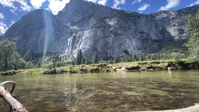
Highway 120 acts as the main artery that channels adventurers into the core of Yosemite’s wild expanses. This road isn’t just a route — it’s a lifeline linking key meeting points and park entrances critical for any hike or exploration. Understanding the logistics here is essential whether you’re a weekend wanderer or a seasoned trail seeker.
Access begins at Big Oak Flat Entrance, positioned at the western approach of Highway 120. It's a major gateway granting entry into Yosemite National Park proper. Expect a steady climb of roughly 1,200 feet in elevation over the first few miles as the highway negotiates the foothills, an early hint that the environment is gearing up to assert itself. Parking here fluctuates seasonally, so planning arrival times outside of midday crowds—typically before 9 a.m. or after 4 p.m.—can secure a spot without a lengthy wait.
From this entrance, several popular meeting points await: the trailhead for the Mist Trail to Vernal and Nevada Falls lies about 15 miles east. The terrain between meeting points is varied—pocked by dense pine forests where trees seem to crowd the edges of the road, and open stretches unveiling the distant Sierra crest that dares you onward. This segment demands a focus on hydration and proper footwear; the shifting elevation and variable trail surfaces reward boots with steady grip and ankle support.
Further along Highway 120 is Tuolumne Meadows, accessed via a turnoff near the 48-mile mark from the entrance. Many hikers meet here before striking into high-country trails. The meadow itself is a broad expanse that feels almost alive with movement—the wind pushing grasses in waves, rivers challenging your attention with their cold, forceful flows. Seasonal influx means early summer to early fall is prime for access, but winter’s snowpack can close this area entirely.
Logistics wise, coordinating meeting points along Highway 120 requires attention to vehicle readiness and awareness of parking regulations. Designated lots fill fast during peak seasons. Carpooling or shuttle services are wise choices, especially during summer weekends. The National Park Service posts live updates about road status and parking lot capacities, making online checks part of the practical prep.
Timing your visit is another essential element. Early starts expose you to the park’s changing light as sun pushes through the foliage; afternoons risk crowds and rising temperatures. With daylight fading quickly in later months, plan your approach to leaving to avoid driving in reduced visibility, since Highway 120 ascends through twisting mountain passes.
Every bend on Highway 120 invites you into a concentrated encounter with Yosemite’s terrain—roads that climb, rivers that challenge, and forests that drink in the passing hours. Being prepared, informed, and timely transforms the logistics from a mere chore to part of an unfolding adventure. Respect the road and its natural forces; it’s fiercely itself and demands the same from those who travel it.
Nearby Trips
All Adventures
Boat Charters
Water Activities
Adventures near Groveland
Discover the unique and memorable adventures that make Groveland special.
Frequently Asked Questions
Are there shuttle services along Highway 120?
During peak seasons, Yosemite operates free shuttle buses connecting major trailheads and parking areas accessed via Highway 120, reducing parking demand and congestion.
What wildlife might be encountered near Highway 120 entrances?
Visitors may see black bears foraging near park entrances, mule deer crossing roads at dusk, and a variety of birds including Steller’s jays and woodpeckers inhabiting the forest edges.
Is Highway 120 open year-round?
No. Winters can close sections of Highway 120, particularly the Tioga Pass area. Big Oak Flat Entrance remains open most of the year but weather can cause temporary closures.
Are there lesser-known viewpoints accessed via Highway 120?
Yes. The El Capitan Picnic Area off Highway 120 offers a quiet vantage point away from crowds, with clear views of El Capitan’s imposing granite face, often overlooked during busy seasons.
What time of day is best to start hikes from these meeting points?
Early morning starts before 8 a.m. are best to avoid crowds and take advantage of cooler temperatures, especially in summer months.
What environmental protection measures should visitors follow?
Stick to marked trails to protect fragile plant life, pack out all trash, and keep wildlife at a respectful distance to maintain the park’s delicate ecological balance.
Recommended Gear
Sturdy Hiking Boots
Protects ankles and provides traction on gravel, rocks, and forested trail surfaces.
Water Bottle or Hydration Pack
Essential for staying hydrated, especially during warmer months when heat and exertion increase fluid loss.
Layered Clothing
Helps adjust to temperature swings common with elevation changes and time of day.
GPS Device or Offline Map
Useful for navigating meeting points and trails if cellphone service is spotty.
Local Insights
Hidden Gems
- "El Capitan Picnic Area"
- "Wawona Tunnel View off Highway 41 (a short detour connected to Highway 120)"
- "Tenaya Lake overlook"
Wildlife
- "Black bears"
- "Mule deer"
- "Coyotes"
- "Peregrine falcons"
History
"Highway 120 roughly follows routes established by early settlers and the Native American Miwok people, serving as a critical corridor into Yosemite since the early 20th century."