Navigating Mountain Road Conditions in Denver’s Historic Mining Regions
Explore Denver’s historic mining roads where rugged paths and alpine forests converge. This guide offers essential tips and insights to help you prepare for varied road conditions while connecting you to Colorado’s mining heritage and stunning mountain views.
Check Road Status Before Your Trip
Mountain roads here often close seasonally or after storms. Verify current road and weather conditions via local ranger stations or official websites to avoid unexpected closures.
Bring Traction Aids for Gravel Sections
Loose gravel and dirt patches reduce vehicle control. If hiking, sturdy boots with good grip and trekking poles improve stability on shifting terrain.
Start Early to Avoid Afternoon Weather
Mountain weather can turn quickly—early starts give you safer daylight windows before storms roll in and temperatures drop.
Pack Water and Layered Clothing
Dry mountain air demands constant hydration. Layered clothes help you adjust to temperature swings between shaded forest and high-altitude open stretches.
Navigating Mountain Road Conditions in Denver’s Historic Mining Regions

Historic Tour of Denver and the Mountain Mining Towns
Step into Colorado’s past on a 6-hour scenic tour that uncovers ghost towns and mountain vistas near Denver. Discover rich mining history while enjoying awe-inspiring Rockies views in this memorable adventure.
Denver’s historic mining regions invite adventurers to explore roads where nature and history collide, demanding respect from every traveler. These mountain roads, carved through steep grades and forests that lean in close, are not for the faint of heart but reward preparation and attentiveness. From the sharp switchbacks of Guanella Pass to the rugged stretches near Mount Evans, each route weaves through landscapes fiercely shaped by mining lore and unyielding mountain forces.
Road conditions here shift quickly. Gravel patches dare you to maintain traction, while unexpected potholes push drivers to slow and steady progress. Elevations often rise beyond 10,000 feet, with narrow lanes flanked by rock cliffs or dense stands of pine and spruce that seem to move in the wind’s restless rhythm. Expect weather to turn without warning—the sky’s temperament in the mountains favors sudden afternoon showers, fog that cloaks the route in mystery, or snow lingering late in the season.
Distances along these roads vary, but many key stretches range from 12 to 30 miles one way, with elevation gains between 2,500 and 4,000 feet. Trails adjacent to these roads offer access to former mining sites, abandoned shafts, and panoramic viewpoints that let the forest breathe beneath you while peaks hold their silent watch. Both day hikers and seasoned explorers can find challenges suited to their pace—from gentle forest tracks to rugged ascent paths that test endurance and agility.
Hydration and footwear are critical. Mountain air can dry you out faster than expected, especially at altitude. Footwear with solid grip handles uneven terrain and loose gravel better, protecting against slips that the terrain seems eager to invite. Start early to avoid afternoon weather surprises and capitalize on clearer light and cooler temperatures.
Pay attention to signage; many sections have limited cell service and are patrolled less frequently. Check the weather forecast and road advisories before heading out, especially in shoulder seasons when conditions shift rapidly. Carry essentials for sudden weather changes: layers for warmth, rain protection, and emergency supplies.
Ultimately, navigating these roads is about engagement—understanding each bend, respecting the mountain’s mood, and moving forward with care. The reward is a direct link to Colorado’s mining past, framed by landscapes where the earth’s raw character remains fiercely itself, waiting for those ready to meet it on its own terms.
Nearby Trips
All Adventures
Boat Charters
Water Activities
Adventures near Georgetown
Discover the unique and memorable adventures that make Georgetown special.
Frequently Asked Questions
Are these mountain roads accessible by regular passenger vehicles?
Most primary roads in Denver’s historic mining areas can be navigated by cars during dry months if cautious driving is observed. However, some secondary routes are rough, steep, or narrow and may require high-clearance or four-wheel-drive vehicles, especially after rain or snow.
When is the best time to visit for hiking without heavy crowds?
Spring or early fall offers less crowded trails with cooler temperatures. Summer sees more visitors and afternoon thunderstorms, so plan early starts to avoid busy and wet afternoon conditions.
What wildlife might I encounter on these mountain roads?
Keep alert for mule deer and elk crossing roads, especially at dawn or dusk. Smaller mammals like marmots and pika are common near rocky outcrops, while birds of prey patrol the skies overhead.
How do I prepare for altitude changes driving through mining regions?
Take it slow to let your body acclimate. Hydrate well and avoid heavy exertion immediately after ascending. If you feel symptoms like headaches or dizziness, rest and descend if necessary.
Are there any notable historical sites accessible from these roads?
Yes, several abandoned mining towns such as Montezuma and Loveland Pass area offer remnants of mining operations. Interpretive markers often detail the area's gold rush history and industrial heritage.
What environmental considerations should visitors keep in mind?
Stick to marked roads and trails to minimize erosion and protect fragile alpine vegetation. Pack out all trash and respect closed areas to help preserve habitats and mining ruins alike.
Recommended Gear
Sturdy Hiking Boots
Provides ankle support and traction needed on uneven, rocky, and gravel-filled road sections.
Layered Clothing
Allows quick adjustment to shifting mountain temperatures and weather changes.
Hydration System
Keeps you hydrated at elevation where dehydration can sneak up quickly.
Emergency Weather Gear
Rain jacket, insulated layers, and a compact emergency blanket prepare you for sudden storms or cold snaps.
Local Insights
Hidden Gems
- "The overlook near Guanella Pass offers an often overlooked vantage where mountain ridges layer into the horizon."
- "Quiet sections along Saint Mary’s Glacier trail provide peaceful views of rushing ice-fed streams."
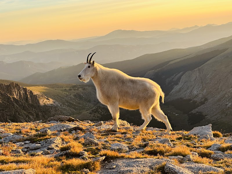
Wildlife
- "Mule deer"
- "Mountain goats"
- "Pikas"
- "Golden eagles"
History
"These roads trace pathways once foundational to Colorado’s gold and silver rush, with mining camps that once bustled with activity now quiet monuments to a demanding era."