THE ADVENTURE COLLECTIVE® · Independent discovery and booking for outdoor travel

A demanding single-day climb that takes you from coffee terraces through dry forest to the sulfur-scented crater of Concepción—Ometepe’s active peak. Expect stiff elevation gain, loose volcanic rock, and panoramic views of Lake Nicaragua.
A demanding single-day climb that takes you from coffee terraces through dry forest to the sulfur-scented crater of Concepción—Ometepe’s active peak. Expect stiff elevation gain, loose volcanic rock, and panoramic views of Lake Nicaragua.
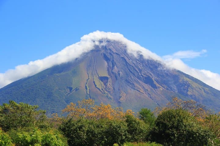
Before dawn the island feels like a held breath. You meet your guide in a hotel lobby in Moyogalpa, climb into a 4x4 and roll through banana stands slick with overnight humidity toward Urbaite, the village at Concepción’s shoulder. As the sun pries light from the horizon, the volcano’s flank—steep, dark, and cut with gullies—stares back. The climb begins on narrow dirt roads that give way to single-track through coffee terraces, then into a dry tropical forest that seems to watch you as you pass.
Verified experiences and guided adventures in the surrounding area.
Operated by Vapues Travel · Moyogalpa, Rivas
Before dawn the island feels like a held breath. You meet your guide in a hotel lobby in Moyogalpa, climb into a 4x4 and roll through banana stands slick with overnight humidity toward Urbaite, the village at Concepción’s shoulder. As the sun pries light from the horizon, the volcano’s flank—steep, dark, and cut with gullies—stares back. The climb begins on narrow dirt roads that give way to single-track through coffee terraces, then into a dry tropical forest that seems to watch you as you pass.
Geology and history are written in the rock underfoot. Concepción is a young, active stratovolcano—the taller of Ometepe’s twin peaks—rising to about 1,610 meters. It and its neighbor, Maderas, once welded the island together from repeated lava flows and ash. Indigenous communities and later colonial settlers farmed the lower slopes; today small coffee growers still tend plots that hug the trail.
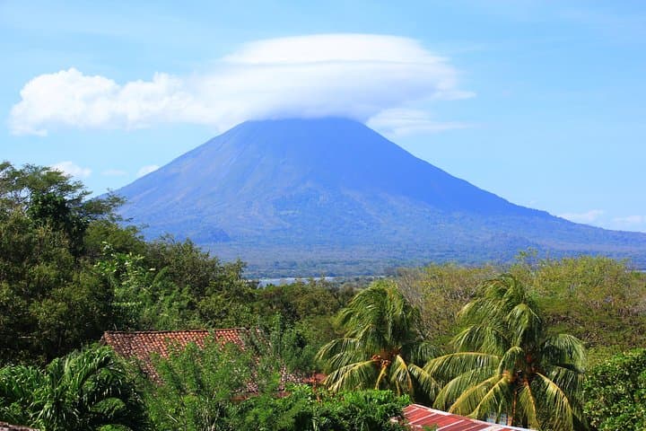
The ascent is honest: expect roughly 14 kilometers round-trip with about 1,250 meters (4,100 feet) of elevation gain, and a full day—around 10 hours—on your feet. Below the treeline the forest shades you; above it the sun asserts itself. The last kilometers are volcanic—loose scoria, angular boulders and short sections of chimney-like scrambling. Fumaroles breathe sulfur near the crater; on clear days the summit rewards you with spare, expansive views over Lake Nicaragua to the mainland and across to Maderas, whose cloud-wrapped caldera sits in quiet contrast.
Culture here is small-scale and practical: guides are local, lunches are boxed, and the hospitality is direct. Respect for the land is part of island life—most groups travel with minimal gear and careful timing to avoid late-afternoon storms.
Practical guidance: start pre-dawn to avoid midday heat and afternoon showers, carry at least 3 liters of water, and wear sturdy hiking boots with good traction. Trekking poles make the descent kinder on knees. A guided tour is strongly recommended; route-finding above the treeline can be tricky and volcanic rock moves underfoot. If you have heart or back issues, this climb is not appropriate—expect sustained steep sections and high exertion.
Leave no trace: stick to the path, pack out any trash, and avoid disturbing fumaroles. The climb is demanding but elemental—the volcano offers a chance to feel the island push beneath your boots and the crater to sigh steam into the open sky.
challenging.
10 hours.
Requires a high level of cardiovascular fitness and leg strength; regular hikers or athletes will manage best.
Plan for about 14 km round-trip with roughly 1,250 m (4,100 ft) of elevation gain; most groups spend about 10 hours including breaks.
Yes—local guides handle route-finding above the treeline, assess volcanic activity, and manage safety on loose rock.
High fitness is required: regular uphill hiking experience, strong cardiovascular fitness, and sturdy knees for long descents.
Concepción is active with fumaroles; guides monitor conditions and keep groups at safe distances from vents—the main hazards are steep terrain and loose rock rather than eruptions on normal tour days.
Bring a boxed lunch (included), high-energy snacks, and at least 3 liters of water per person; electrolyte mixes help on hot sections.
Not recommended for children under 14 due to the sustained physical demands and exposed sections.
Ometepe’s twin cones formed over millennia; Concepción’s eruptions shaped local agriculture and settlement patterns and left archaeological traces in lowland villages.
Trails are vulnerable to erosion—stay on established paths, carry out waste, and support local guides to ensure sustainable tourism.
Vapues Travel operates guided outdoor trips and adventures with an emphasis on safety, stewardship, and memorable experiences.
Before dawn the island feels like a held breath. You meet your guide in a hotel lobby in Moyogalpa, climb into a 4x4 and roll through banana stands slick with overnight humidity toward Urbaite, the village at Concepción’s shoulder. As the sun pries light from the horizon, the volcano’s flank—steep, dark, and cut with gullies—stares back. The climb begins on narrow dirt roads that give way to single-track through coffee terraces, then into a dry tropical forest that seems to watch you as you pass.
Before dawn the island feels like a held breath. You meet your guide in a hotel lobby in Moyogalpa, climb into a 4x4 and roll through banana stands slick with overnight humidity toward Urbaite, the village at Concepción’s shoulder. As the sun pries light from the horizon, the volcano’s flank—steep, dark, and cut with gullies—stares back. The climb begins on narrow dirt roads that give way to single-track through coffee terraces, then into a dry tropical forest that seems to watch you as you pass.
Geology and history are written in the rock underfoot. Concepción is a young, active stratovolcano—the taller of Ometepe’s twin peaks—rising to about 1,610 meters. It and its neighbor, Maderas, once welded the island together from repeated lava flows and ash. Indigenous communities and later colonial settlers farmed the lower slopes; today small coffee growers still tend plots that hug the trail.
The ascent is honest: expect roughly 14 kilometers round-trip with about 1,250 meters (4,100 feet) of elevation gain, and a full day—around 10 hours—on your feet. Below the treeline the forest shades you; above it the sun asserts itself. The last kilometers are volcanic—loose scoria, angular boulders and short sections of chimney-like scrambling. Fumaroles breathe sulfur near the crater; on clear days the summit rewards you with spare, expansive views over Lake Nicaragua to the mainland and across to Maderas, whose cloud-wrapped caldera sits in quiet contrast.
Culture here is small-scale and practical: guides are local, lunches are boxed, and the hospitality is direct. Respect for the land is part of island life—most groups travel with minimal gear and careful timing to avoid late-afternoon storms.
Practical guidance: start pre-dawn to avoid midday heat and afternoon showers, carry at least 3 liters of water, and wear sturdy hiking boots with good traction. Trekking poles make the descent kinder on knees. A guided tour is strongly recommended; route-finding above the treeline can be tricky and volcanic rock moves underfoot. If you have heart or back issues, this climb is not appropriate—expect sustained steep sections and high exertion.
Leave no trace: stick to the path, pack out any trash, and avoid disturbing fumaroles. The climb is demanding but elemental—the volcano offers a chance to feel the island push beneath your boots and the crater to sigh steam into the open sky.