THE ADVENTURE COLLECTIVE® · Independent discovery and booking for outdoor travel

A compact, guided ascent to Piton de la Petite Rivière Noire — Mauritius’ highest point — that pairs steady trail work with sweeping 360° views. This 3–4 hour hike is ideal for travelers wanting a high-reward, low-tech mountain experience with local guiding and photo coverage.
A compact, guided ascent to Piton de la Petite Rivière Noire — Mauritius’ highest point — that pairs steady trail work with sweeping 360° views. This 3–4 hour hike is ideal for travelers wanting a high-reward, low-tech mountain experience with local guiding and photo coverage.
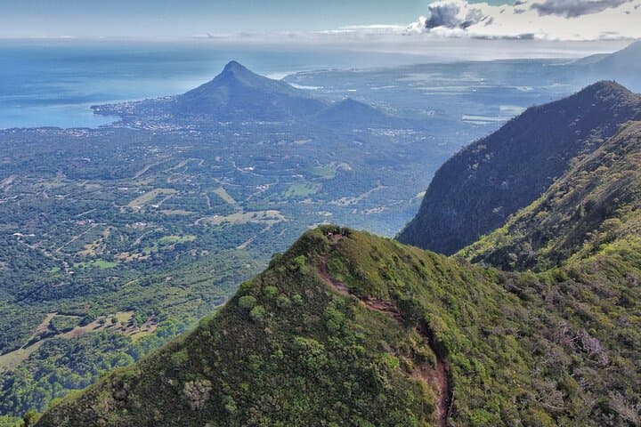
You start at a roadside parking cut into the rim of Black River Gorges National Park, where the wind already tugs at your shirt and the island’s scale opens like a map. The trail moves away from the viewpoint through a patchwork of faded sugarcane terraces and native forest; ferns brush your calves, and orchids hide in folds of rock. The path climbs steadily but straightforwardly — the uphill asks for steady breathing rather than heroics — and within an hour the lowlands shrink into a green sea, the ocean a silver arc on the horizon.
Verified experiences and guided adventures in the surrounding area.
Operated by Mauritius Friendly · Chamarel, Rivière Noire
You start at a roadside parking cut into the rim of Black River Gorges National Park, where the wind already tugs at your shirt and the island’s scale opens like a map. The trail moves away from the viewpoint through a patchwork of faded sugarcane terraces and native forest; ferns brush your calves, and orchids hide in folds of rock. The path climbs steadily but straightforwardly — the uphill asks for steady breathing rather than heroics — and within an hour the lowlands shrink into a green sea, the ocean a silver arc on the horizon.
Piton de la Petite Rivière Noire — Black River Peak — is 828 meters above sea level, the highest point on Mauritius, shaped by ancient volcanic flows that created steep ridgelines and deep ravines. The mountain carries the island’s geological story: basalt bedrock scarred by erosion, soils that feed pockets of endemic ebony and takamaka, and slopes where introduced species and reforestation efforts meet. Culturally, the area sits within the Black River region, where Creole villages, colonial sugar history, and conservation-minded land managers collide — the park was established to protect the last tracts of original forest and the wildlife that depends on them.
On summit day you’ll spend about 1.5 hours ascending, 30 minutes soaking in a 360° view, and 1.5 hours descending; the whole outing runs 3–4 hours and covers roughly 7.5 km with 215 m of elevation gain. The terrain is generally well-defined but can become muddy and slippery after rain; the final approaches are steeper and require careful footing. A professional guide leads the route, and the activity includes bottled water and optional photo and video coverage so you won’t miss that crisp, island-wide frame that makes cameras sing.
Practical choices determine the quality of the day. Start early to pull the cloud cap off the summit and avoid midday heat; bring a light rain shell because coastal storms can sweep in fast; choose grippy trail shoes for wet roots and mud. Insect repellent and sunscreen are non-negotiable — the trail swings between sunlit clearings and humid understory. If you’re combining this hike with other west-coast sights, schedule time in Chamarel for the Seven Colored Earth and local rum distilleries.
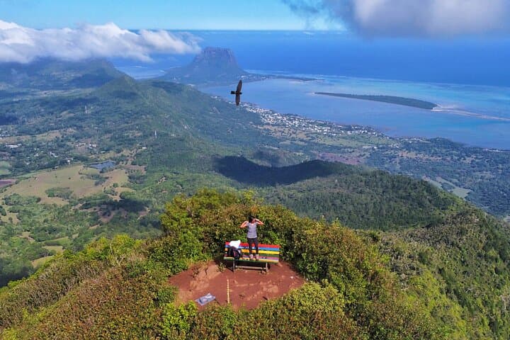
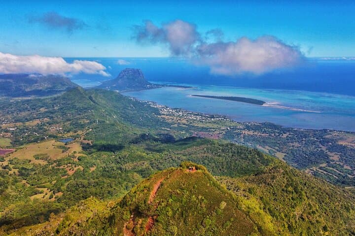
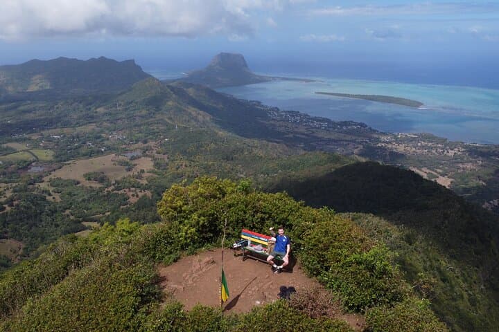
The summit rewards patience: the ocean, distant Le Morne plateau, and inland peaks assemble into a clear panorama that makes the climb feel purposeful. The mountain’s slopes, meanwhile, demand respect — they change with the weather and are part of a fragile ecosystem. Treat the trail like a shared resource: stay on the path, pack out waste, and let the forest keep its quiet.
moderate.
3–4 hours.
Suitable for travelers with basic fitness; able to walk 7.5 km with steady uphill for 1.5 hours.
The route is rated low-moderate — about 1.5 hours up with a short steeper finish; 7.5 km total and 215 m elevation gain make it accessible to most active walkers.
Yes — the tour includes a professional guide, bottled water, and optional photo/video coverage; meeting point is Black River Gorges Viewpoint parking (Plaines Champagne Road, B103).
Closed, grippy hiking shoes or trail runners are recommended due to potential mud and slick roots, especially after rain.
Trails become slippery in rain; the operator does not automatically cancel for bad weather — check conditions and be prepared with a rain shell.
Most visitors drive or are transferred from nearby lodgings in Chamarel or Black River; the meeting point is a public parking area at the Black River Gorges viewpoint on Plaines Champagne Road (B103).
Service animals are allowed; the hike is suitable for older children with good stamina, but not recommended for people with serious heart problems.
Black River Peak sits within Black River Gorges National Park, an area set aside in the 1990s to protect native forest remnants and endangered species on Mauritius.
Invasive plants and animals threaten endemic species; stick to trails, avoid introducing seeds, and support local reforestation and park fees.
Mauritius Friendly operates guided outdoor trips and adventures with an emphasis on safety, stewardship, and memorable experiences.
You start at a roadside parking cut into the rim of Black River Gorges National Park, where the wind already tugs at your shirt and the island’s scale opens like a map. The trail moves away from the viewpoint through a patchwork of faded sugarcane terraces and native forest; ferns brush your calves, and orchids hide in folds of rock. The path climbs steadily but straightforwardly — the uphill asks for steady breathing rather than heroics — and within an hour the lowlands shrink into a green sea, the ocean a silver arc on the horizon.
You start at a roadside parking cut into the rim of Black River Gorges National Park, where the wind already tugs at your shirt and the island’s scale opens like a map. The trail moves away from the viewpoint through a patchwork of faded sugarcane terraces and native forest; ferns brush your calves, and orchids hide in folds of rock. The path climbs steadily but straightforwardly — the uphill asks for steady breathing rather than heroics — and within an hour the lowlands shrink into a green sea, the ocean a silver arc on the horizon.
Piton de la Petite Rivière Noire — Black River Peak — is 828 meters above sea level, the highest point on Mauritius, shaped by ancient volcanic flows that created steep ridgelines and deep ravines. The mountain carries the island’s geological story: basalt bedrock scarred by erosion, soils that feed pockets of endemic ebony and takamaka, and slopes where introduced species and reforestation efforts meet. Culturally, the area sits within the Black River region, where Creole villages, colonial sugar history, and conservation-minded land managers collide — the park was established to protect the last tracts of original forest and the wildlife that depends on them.
On summit day you’ll spend about 1.5 hours ascending, 30 minutes soaking in a 360° view, and 1.5 hours descending; the whole outing runs 3–4 hours and covers roughly 7.5 km with 215 m of elevation gain. The terrain is generally well-defined but can become muddy and slippery after rain; the final approaches are steeper and require careful footing. A professional guide leads the route, and the activity includes bottled water and optional photo and video coverage so you won’t miss that crisp, island-wide frame that makes cameras sing.
Practical choices determine the quality of the day. Start early to pull the cloud cap off the summit and avoid midday heat; bring a light rain shell because coastal storms can sweep in fast; choose grippy trail shoes for wet roots and mud. Insect repellent and sunscreen are non-negotiable — the trail swings between sunlit clearings and humid understory. If you’re combining this hike with other west-coast sights, schedule time in Chamarel for the Seven Colored Earth and local rum distilleries.
The summit rewards patience: the ocean, distant Le Morne plateau, and inland peaks assemble into a clear panorama that makes the climb feel purposeful. The mountain’s slopes, meanwhile, demand respect — they change with the weather and are part of a fragile ecosystem. Treat the trail like a shared resource: stay on the path, pack out waste, and let the forest keep its quiet.