
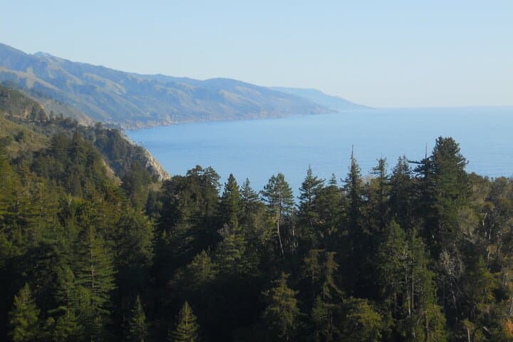
What the day feels like
You round a bend and the ocean opens like a held breath—gray-green water studded with foam, cliffs serrated with live oak and manzanita, and the slender silhouette of Bixby Creek Bridge cutting a graceful arc against the sky. Wind tugs at your jacket; gulls wheel. For 195 minutes, the coast makes its case: every lookout is an argument for slow travel. On the Big Sur Sightseeing Tour you trade the map for a guide who knows which pullouts are worth the stop, which redwoods are the oldest groves, and where the light hits the cliffs best for photos. Bookers get a compact education in geology and ecology alongside the cinematic views that define California’s Highway 1.
This stretch of road is a layered story. Geologically it’s young, uplifted by tectonics and scoured by the relentless erosive appetite of the Pacific. Sea stacks and wave-cut platforms are the coastline’s fingerprints; Bixby Creek Bridge—completed in 1932—spans a dramatic gorge and stands as an early engineering triumph that finally tethered remote coastal communities to the north and south. Cultural history is dense here, too: Indigenous Esselen and Salinan peoples inhabited steep canyons and river mouths for millennia, Europeans arrived with ranches and fog-shrouded missions, and later artists and conservationists defended the roadside as a place of public access rather than private development.
The itinerary is built for contrast. You’ll begin with the cinematic pull of Highway 1—headlands, narrow coves, and sweeping ocean exposures—then pause at the 1932 concrete bridge for a classic coastal panorama. Further south, the tour drops into the humidity of an old-growth redwood stand at Big Sur Lodge, where trunks rise like cathedral columns and a short guided nature walk threads the understory. There’s a quirky stop at The River Inn, where the chairs perched over the Big Sur River make for a Photopoint and a quick refreshment. If you’re looking to compress a day’s worth of discoveries into fewer than four hours, this tour gives everything in digestible, memorable bites.
Why go guided? On a winding road known for dramatic pullouts and tricky parking, a guide unclutters the logistics—timing each stop to avoid the worst crowds, explaining the science behind sea-spray weathering, and choosing viewpoints that photographers prize. The tour also packs local stories: the bridge’s 1930s construction, the old logging history that shaped the redwood groves, and how seasonal river crossings change the sound and mood of the valley. For photographers and first-timers especially, the experience stitches together the “why” behind the view.
Practicalities are straightforward. The tour lasts about 3 hours and 15 minutes, covering highway viewpoints and a guided walk in the redwoods; be prepared for short walks and a few uneven surfaces. Cell service is patchy—rely on your guide for logistics and bring a printed or offline map if you plan to continue exploring on your own. Dress in layers: midday sun can be warm on exposure, while the fog and riverine pockets can chill quickly. Footwear should be sturdy enough for short trail sections—think trail shoes rather than sandals.
Timing is everything. Morning light softens the cliffs and often yields clearer visibility; however, late afternoon brings golden hues and quieter pullouts after day-trippers depart. Spring and early summer fill the canyons with wildflowers and higher rivers; fall often presents the clearest skies and long light ideal for landscape shots. Wherever you land, allow the schedule some slack—Big Sur is scenic because it resists being hurried.
If you want to extend the day, the tour’s stops are ideal jumping-off points: hike a longer redwood loop from Big Sur Lodge, drive a short distance to Pfeiffer Beach’s mauve sand and keyhole rock, or stop at Nepenthe for a sunset beer and a meal with an unmatched cliffside view. For a compact introduction, though, this is the trip: the tactile contrast of salt and cedar, the audible hush of redwood groves, and a sequence of views that explains why Highway 1 is more than a road—it’s a corridor of curiosity.
Book smart: the tour operates with small-group attention and instant confirmation, but seasonal demand spikes in summer and during fall color windows. Bring a charged battery for your camera, a collapsible water bottle, and a few dollars for coffee at The River Inn—those small interactions help local businesses keep the corridor public and vibrant. If you want to read more or reserve a tour, see the full guided itinerary and booking details at this Big Sur Sightseeing Tour page: <a href="https://app.advcollective.com/local-experts/big-sur-sightseeing-tour-highway-1-coastal-views-bixby-bridge-redwood-walk">Big Sur Sightseeing Tour — Highway 1, Bixby Bridge, Redwood Walk</a>.
In the end, the coast asks you to slow down. The bridge will still be there, the redwoods will not hurry, and the ocean will keep making and unmaking the cliffs. If you want a concentrated, expert-led afternoon that leaves you both informed and a little quieter from the view, this tour does the job neatly—no fuss, no overpromising, only the coast doing what it does best.
Trail wisdom
Small choices, better day.
Layer Up for Microclimates
Fog and sun can alternate by the minute—wear layers you can add or shed quickly.
Bring a Refillable Water Bottle
Hydration options can be limited on the road; aim for 1–2 liters per person.
Choose Trail Shoes
Short uneven walks in the redwoods require stable footwear—trail runners are ideal.
Charge Batteries & Bring Cards
Cell service is intermittent; bring a charged camera battery and spare memory cards.
Local knowledge
Read the place, not just the route.
Watch for native species including California sea otter, Peregrine falcon.
Keep an eye out for wildlife during the transition between areas and habitats. Respect distance guidelines.
Much of Big Sur is protected in state parks and private preserves—stay on trails, pack out trash, and support local businesses to help sustain the corridor.
Follow the guide's instructions on size limits, ethical handling, and leave-no-trace practices.
Pfeiffer Beach (for unique sand and keyhole rock). The Nepenthe dining terrace for sunset views
Locally recommended viewpoints and quiet spots known best to local operators.
Big Sur’s road access was substantially improved with the construction of Highway 1 and the 1930s bridges like Bixby Creek Bridge, opening the coast to visitors while also prompting conservation debates.
Maritime roots and regional tradition shape the waterways and working coasts.
Seasonal guide
Four versions of the same landscape.
Spring
Best forWildflowers · Higher river flow · Cooler temps
ChallengesOccasional rain · Foggy mornings
Spring brings green canyons and blooming coastal scrub; expect cooler, sometimes wet mornings and vibrant rivers.
Summer
Best forClear ocean views · Long daylight · Warm exposed overlooks
ChallengesCrowds · Patchy fog (June gloom)
Summer offers longer days and warm mid-afternoon light, but plan around peak visitor times and morning coastal fog.
Fall
Best forCrisp skies · Golden light · Fewer crowds
ChallengesVariable marine layer · Shorter daylight
Fall is often the clearest season with dramatic light—ideal for photography and quieter pullouts.
Winter
Best forStorm-watching · Lush greenery · Lower visitor numbers
ChallengesRoad closures · Heavy rain and runoff
Winter offers dramatic surf and greener canyons, but storms can affect highway safety—check conditions before travel.
Operator details
What the booking data adds.
Included
- ✓Local guide
- ✓Air-conditioned vehicle
- ✓Included on tours of four or more
Not included
- —Gratuities
Good to know
- ✓Service animals allowed
- ✓Public transportation options are available nearby
- ✓Suitable for all physical fitness levels
Pack with intention
What to bring.
Good to know
Common questions.
The tour runs approximately 195 minutes (about 3 hours and 15 minutes) and includes several short stops and a guided redwood walk.
Plan the edges
The details that make the day easier.
Bixby Creek Bridge, completed in 1932, is one of the tallest single-span concrete bridges in the United States and is a frequently photographed landmark on Highway 1.
After the tour, head to Big Sur Bakery for wood-fired pizza or Nepenthe for a sunset cocktail with sweeping coastal views; The River Inn offers a relaxed river-side lunch and local fare—supporting these small venues keeps the corridor vibrant.
- Closest airport
- Monterey Regional Airport (MRY) or San Jose (SJC). Typical driving time from Monterey to central Big Sur: ~45–60 minutes. Cell service: intermittent—expect gaps. Permits
- passes
- No special permits required for the tour, but some state park parking and entrance fees may apply.
Big Sur includes fragile marine and forest ecosystems—stay on designated trails, pack out all waste, and keep a respectful distance from wildlife to minimize impact.
Explore by topic
Follow the threads.
Keep exploring
Make the story part of the trip.
In four hours you can move from shaded canyon ferns to wind-scoured coastal ridgelines, guided by someone who knows where the light—and the hidden views—live. This private half-day hike on the Monterey Peninsula or Big Sur is compact, curated, and perfect for travelers who want depth without a multiday commitment.
 Related story
Beneath a sky of shifting light, Skaftafell’s ice reads like a map of time. This three-hour guided glacier hike mixes technical instruction with geology and culture: compact, safe, and unforgettable.
 Related story
Lose the city for a few hours without leaving it: this 5-mile, 900-foot-gain Forest Park loop threads old-growth pockets, city viewpoints, and cultural landmarks for a compact taste of Portland’s wild side. Expect moss, roots, and stories.