
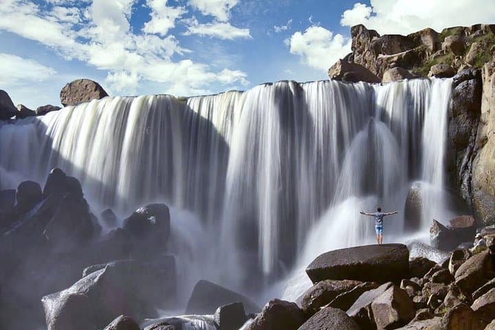
What the day feels like
By the time the bus detaches from Arequipa’s ring road, the city’s red volcanic terraces fall away and the high puna opens like a slow-breathing beast. Wind translates across the grasslands in flat, insistent gusts; tufts of ichu grass tremble like hands waving farewell. At 4,600 meters, the air is thin enough to make every step deliberate, and the landscape sharpens—jagged volcanic remnants, salt flats glinting in low sun, a waterfall that seems to arrive out of nowhere. This is the kind of day that shrinks most itineraries to the essentials: walk, watch, acclimate, and let the place do the talking.
The twin attractions of this loop—the Pillones Waterfall and the Imata Stone Forest—feel like natural counterpoints. Pillones is water’s quiet insistence, a steep sheet of melt and spring water daring you to stand on the lip and feel the spray cool a sunburned face. The Imata Stone Forest is wind and time made visible: columns and pinnacles of volcanic and sedimentary rock sculpted by eons of freeze-thaw, erosion and salt. Together they make a compact, cinematic day trip from Arequipa and a useful primer on the region’s geology and high-Andean ecology.
Geologically, this landscape is readable if you know how to look. The Salinas y Aguada Blanca Reserve—whose high plateau provides the backdrop for both sites—sits where volcanic flows meet uplifted sedimentary beds. Over millennia, wind and water have carved the harder rock into columns, leaving the softer material to erode away and produce that enchanted “stone forest” effect. Humans have read these features for just as long: local Quechua-speaking communities practiced transhumant herding here, rotating llamas and alpacas across puna grasslands and salt pans. You’ll notice herding paths and corrals, places where pastoral life continues alongside geologic theater.
There’s a cultural pulse to the route as well. The Salinas and Aguada Blanca Reserve is living conservation—vicuñas, highland waterfowl and Andean foxes thread through the same landscape shepherds rely upon. Local guides point out seasonal salt flats used historically for small-scale extraction and the habitational ruins that nod to the pre-Columbian past. It’s a landscape shaped as much by human resilience as by tectonic force.
Practicalities matter at altitude. The shared-day tour out of Arequipa generally runs about eight hours and moves at a pace that accounts for elevation and short acclimatization stops. Expect a bit of walking around both main sites—uneven ground, rocky approaches to the viewpoints and some short, steep stretches. Hiking boots or sturdy trail shoes, layers for wind and sun, and a steady supply of water will take you far. Don’t underestimate the sun: high-altitude UV reflects off rock and salt, so a wide-brim hat and sunscreen are essentials.
Timing shifts the mood. Early morning light pours over the stone columns and keeps the puna air crisp; afternoons can throw up sudden squalls, especially outside the dry season. That variability is part of the charm: the landscape can feel austere one hour, intimating a strange, otherworldly calm the next. On any given day, the walk between viewpoint and waterfall is an opportunity to listen to the place—rocks grinding in wind, distant livestock bells—and to test how your lungs acclimatize to the altitude.
Logistics are straightforward for independent travelers and comfortable for those booking a guided departure. Many visitors choose a shared-van option from Arequipa which includes a guide and transfer back in the early evening. That’s practical: the high plains can be deceptive in distance and time, and a driver familiar with the route reduces hours spent navigating gravel roads. The tour price is moderate and often includes entrance to the reserve; confirm whether food or water is included before you go.
For photographers, the interplay of scale and texture is the day’s main offering. Wide lenses capture the stone columns against a big sky; telephoto brings vicuñas or distant shepherds into personal scale. Bring a polarizer to deepen blues and cut glare on salt pans. At sunset, the volcanic rocks warm to copper and the shadows lengthen, giving a cinematic depth to otherwise austere formations.
If you plan to go, pace yourself. Walk deliberately, drink small amounts often, and keep your day flexible. Acclimatization is the real variable here—someone who’s arrived in Arequipa the night before will feel different from someone who’s spent several days at elevation. Respect the landscape and local customs: stick to paths where they exist, don’t disturb grazing animals, and follow your guide’s recommendations for water sources and rest stops.
The payoff is immediate. Pillones’ cascade isn’t the highest waterfall you’ve seen globally, but its presence in the high Andean basin—sudden, fresh and loud—creates a contrast with the inert grandeur of the Imata pillars. Side by side they make a disciplined argument in favor of slow travel: observe, learn, and let the place rewrite your sense of scale. For travelers based in Arequipa with a single day to spare, this loop delivers a concentrated, elemental experience of southern Peru’s highlands without the logistical heft of multi-day treks.
If you want a primer before you go, local operators and resources can help plan acclimatization and timing. For a reliable local guide and further details on the route, equipment and seasonal conditions, check this local expert listing for Pillones and the Imata Stone Forest: <a href='https://app.advcollective.com/local-experts/explore-pillones-waterfall-and-imata-stone-forest-arequipas-high-altitude-natural-wonders'>Pillones Waterfall and Imata Stone Forest</a>. It’s the practical touchpoint between the raw landscape and an organized, safe day trip out of Arequipa.
You’ll come away with a tighter breathing rhythm, an appetite for altitude, and a notebook of images: columns like petrified forests, a waterfall that insists, and the wide, weathered sky above the puna. It’s not the Andes at their most dramatic, but it’s an honest, accessible day in a place that demands attention and repays it with austere beauty.
Trail wisdom
Small choices, better day.
Pace for Altitude
Move deliberately and take frequent water breaks—altitude, not distance, is the real challenge here.
Sun Protection
High UV at 4,600m means sunscreen, a brimmed hat, and sunglasses are non-negotiable.
Footwear Matters
Sturdy trail shoes with good tread handle rocky approaches and uneven trails better than sneakers.
Respect Grazing Areas
Stick to paths and avoid disturbing local herds or corrals—these are active pastoral lands.
Local knowledge
Read the place, not just the route.
Watch for native species including Vicuña, Andean fox.
Keep an eye out for wildlife during the transition between areas and habitats. Respect distance guidelines.
The reserve protects fragile puna ecosystems and vicuña populations—stay on trails, avoid feeding wildlife, and pack out all trash.
Follow the guide's instructions on size limits, ethical handling, and leave-no-trace practices.
Small vantage point above Pillones Falls for uninterrupted views. Less-trafficked side trails through the lower columns of the Imata Stone Forest
Locally recommended viewpoints and quiet spots known best to local operators.
The landscape sits within the Salinas y Aguada Blanca Reserve, a protected high-Andean area shaped by volcanic activity and centuries of pastoralism.
Maritime roots and regional tradition shape the waterways and working coasts.
Seasonal guide
Four versions of the same landscape.
Spring
Best forFewer crowds · Wildflower patches · Crisp mornings
ChallengesUnpredictable weather · Cold nights
Spring brings fresher water flows and blooming puna grasses but can still carry cold snaps; layer up.
Summer
Best forLonger daylight · Warmer midday temps
ChallengesAfternoon showers · Muddy sections
Summer (austral winter to spring transition) offers comfortable daytime temps but watch for sudden showers.
Fall
Best forClear skies · Stable weather · Great photography light
ChallengesCool mornings · Shorter days
Fall is typically dry and clear—ideal for vistas and photography—though mornings remain cold.
Winter
Best forDry conditions · Blue skies · Best visibility
ChallengesVery cold nights · Possible high winds
Winter (May–September) is the dry season—optimal visibility and safer road conditions, but bring windproof layers.
Operator details
What the booking data adds.
Included
- ✓guide
- ✓Permanent assistance
- ✓trekking
- ✓transport
Not included
- —Breakfast
- —Lunch
- —Snacks
Good to know
- ✓Service animals allowed
- ✓Not recommended for travelers with spinal injuries
- ✓Not recommended for pregnant travelers
- ✓Suitable for all physical fitness levels
Pack with intention
What to bring.
Good to know
Common questions.
Expect a full-day outing of approximately 6–8 hours including transfers and time at both sites.
Plan the edges
The details that make the day easier.
The Salinas y Aguada Blanca National Reserve was established in 1979 to protect high-altitude ecosystems and vicuña populations.
After the hike, head back to Arequipa’s historic center for hearty rocoto relleno or a plate of chupe de camarones; try a local microbrew or a cup of coca tea to soothe tired legs and aid acclimatization.
- Closest airport
- Rodríguez Ballón Airport (Arequipa)
- Trailhead
- road access via Salinas y Aguada Blanca Reserve
- Driving
- ~1–1.5 hours from Arequipa depending on route
- Cell
- spotty once outside Arequipa; expect limited coverage
- Permits
- reserve entrance fee often included with tours—confirm ahead.
Respect grazing lanes and stay on established paths; the puna is fragile—pack out all trash, avoid disturbing wildlife, and support local guides to ensure sustainable benefits for communities.
Explore by topic
Follow the threads.
Keep exploring
Make the story part of the trip.
In four hours you can move from shaded canyon ferns to wind-scoured coastal ridgelines, guided by someone who knows where the light—and the hidden views—live. This private half-day hike on the Monterey Peninsula or Big Sur is compact, curated, and perfect for travelers who want depth without a multiday commitment.
 Related story
Beneath a sky of shifting light, Skaftafell’s ice reads like a map of time. This three-hour guided glacier hike mixes technical instruction with geology and culture: compact, safe, and unforgettable.
 Related story
Lose the city for a few hours without leaving it: this 5-mile, 900-foot-gain Forest Park loop threads old-growth pockets, city viewpoints, and cultural landmarks for a compact taste of Portland’s wild side. Expect moss, roots, and stories.