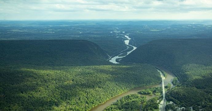
Air Tours in Schnecksville, Pennsylvania

Schnecksville, Pennsylvania

Schnecksville sits on the edge of the Lehigh Valley where low ridgelines, patchwork farmland, and long river corridors create an unexpectedly cinematic landscape from above. Air tours here fold together industrial history, broad agricultural valleys, and Appalachian foothills—offering short scenic hops and custom flights that reveal the region's texture: the sinuous Lehigh River, the spine of Blue Mountain, and the urban-to-rural transition that defines eastern Pennsylvania.

4
Activities
Seasonal — spring through fall (weather-dependent)
Best Months

Top Air Tour Trips in Schnecksville

4 trips • Book with confidence • Instant confirmation

Why Schnecksville Is a Memorable Place for Air Tours

From the low hum of rotors to the hush that follows a single-engine climb, flying over Schnecksville reframes familiar landscapes into cinematic panels of color and line. The region is modest in elevation, but the contrasts are dramatic: narrow ridgelines like Blue Mountain throw long shadows across fertile valley floors; the Lehigh River snakes past industrial legacies and restored riparian corridors; patchwork farms meet suburban edges in a pattern that only becomes legible from the air. For travelers who normally seek vantage points on a ridge or ridgeline, an air tour supplies an immediately accessible, panoramic vantage—an aerial reconnaissance that dissolves roads and fences into tidy compositions and reveals how settlement, industry, and geology have shaped the valley.

Air tours around Schnecksville are as much about context as spectacle. You can use a 20- to 60-minute flight to fold together themes you might otherwise chase on different days: industrial history and adaptive reuse in Allentown and Bethlehem, the agricultural backbone of Lehigh and Northampton counties, and the recreational spine of the Appalachian foothills. Pilots often fly routes that highlight ridgelines, river meanders, and notable landforms, and that leaves room to layer the experience—seasonal color across fall foliage corridors, the soft geometry of spring fields, or the crystalline clarity of cold winter air for long sightlines. The Lehigh Valley’s relatively low elevation means calmer air in many seasons compared with high-mountain flights, and because the area is a short drive from regional population centers, it’s a convenient option for both day-trippers and weekend visitors seeking a distinct perspective.

Beyond the view itself, air tours plug into a broader palette of regional outdoor activities. A morning flight makes for a storytelling opener to a day of trail-running or ridge hiking on nearby public lands; a late-afternoon flight paired with a Lehigh River paddle launches the valley into sharp relief as you transition from air to water; photographers and naturalists use flights to spot potential sites for landscape shoots, birding, and conservation visits. Because these flights are often short, they’re accessible to a wide range of travelers—families, photographers, and seasoned adventurers—while still delivering an unforgettable sense of scale. Practical considerations—weather windows, light quality for photography, weight-and-space limits, and noise-sensitivity near preserves—shape the experience, but with a little planning, an air tour in Schnecksville becomes less a luxury and more an essential way to read a landscape most people only ever cross at ground level.

Air tours convert a day of local exploration into a layered narrative: see a feature from the air, then visit it on foot or by water to complete the story.

Because the terrain is moderate, flights are comfortable for many travelers; glassy winter air often provides the best visibility, while spring and fall offer the most visual variety.

The region's proximity to larger cities makes Schnecksville an accessible launch point for short, high-impact aerial experiences without a long travel commitment.

Activity focus: Scenic aerial reconnaissance and photography
Typical flight lengths: short hops to hour-long tours (varies by operator)
Visibility best after cold fronts and in winter for longest sightlines
Seasonality affected strongly by low-cloud ceilings and wind along ridge lines
Complementary activities: hiking, paddling, winery circuits, and photography tours

Best Time to Visit

Best Months

AprilMaySeptemberOctober

Weather Notes

Spring and fall provide the best balance of visibility and comfortable temperatures; summer can produce afternoon thermals and thunderstorms, while winter yields the clearest long-distance views but may increase cancellations due to low ceilings or icing concerns.

Peak Season

Fall foliage months (September–October) draw the most demand for flights and show the valley at peak color.

Off-Season Opportunities

Winter offers exceptional visibility on clear days and fewer crowds, though flight availability is more weather-dependent.

Frequently Asked Questions

Do I need experience to take an air tour?

No prior experience is required. Tours are designed for first-time flyers as well as seasoned travelers; operators will brief you on safety and seating before departure.

Are air tours safe?

Commercial air tours operate under strict maintenance and pilot certification rules. Ask operators for their safety records, aircraft type, and pilot experience, and verify that flights are conducted under appropriate local regulations.

How do weather and seasons affect flights?

Flights are highly weather-dependent. Low ceilings, heavy winds along ridgelines, and thunderstorms typically lead to delays or cancellations. Operators generally reschedule or refund when conditions are unsafe.

Choose Your Experience Level

Beginner

Short scenic flights (15–30 minutes) focusing on nearby ridgelines, river corridors, and local landmarks—ideal for first-time flyers and families.

  • 20–30 minute valley overview
  • Sunrise or golden-hour short hop for photographers
  • Introductory fixed-wing flight with pilot narration

Intermediate

Longer tours (30–60 minutes) and specialty flights geared toward photographers, naturalists, or visitors wanting wider geographic coverage, possibly including approaches to the Poconos or closer looks at industrial-heritage sites.

  • Extended photography flight along Blue Mountain and Lehigh River
  • Custom route exploring neighboring waterways and valleys
  • Combined aerial + ground itinerary with a local hike or river trip

Advanced

Custom charters and mission-specific flights—photogrammetry, survey observation, or sequential flights timed for light—that require pre-arrangement and experienced operators.

  • Private aerial photography sessions with tailored flight paths
  • Multi-stop charter to regional natural areas and overlooks
  • Collaborative flights for conservation or mapping projects

Insider Tips & Local Knowledge

Confirm weather and the operator’s cancellation policy before you travel. Window seats matter; book early and ask about orientation and camera-friendly windows.

Book morning flights for stable air and cleaner light; late afternoon flights are dramatic but more vulnerable to thermal activity in summer. If photography is your goal, request a flight path and side of the plane in advance to maximize light and minimize glare. Respect wildlife and preserve no-fly zones—many natural areas and preserves have restrictions to protect nesting birds and sensitive habitat. Pair a short flight with a ground activity: land-based hikes at nearby trails, paddling segments on the Lehigh River, or an afternoon at a local winery or farm stand make a compact and rewarding day. Finally, communicate any accessibility needs or concerns with the operator ahead of time so they can advise on seating, boarding, and safety briefings.

What to Bring

Essential

  • Government-issued ID (needed for many flight check-ins)
  • Camera with secure strap and lens hood
  • Layered outerwear (breezes at altitude can feel cool)
  • Sunglasses and sun protection
  • Any necessary motion-sickness medication

Recommended

  • Noise-reducing headphones or earplugs (if not provided)
  • Small binoculars for spotting landmarks
  • A compact emergency contact card with local rendezvous info
  • Phone with charged battery and spare storage for photos

Optional

  • Notebook or voice recorder for on-the-fly notes
  • Light backpack for combining flight with a short hike afterward

Ready for Your Air Tour Adventure?

Browse 4 verified trips in Schnecksville with instant booking

Explore Top 15 Schnecksville, Pennsylvania Adventures →