Why Nazareth Is a Special Place for Air Tours
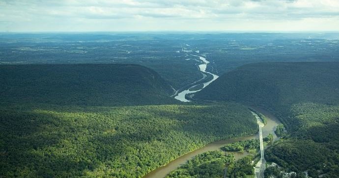
Nazareth sits at a crossroads of two visual worlds: the intricate, human-scaled geometry of northeastern Pennsylvania’s agricultural and industrial past, and the wilder, more weather-sculpted silhouette of the Pocono foothills. Seen from the ground, the town’s brick facades, modest ridgelines, and river corridors read like the quiet chapters of a regional story. From the air, however, that story rearranges itself into a narrative of pattern and movement—rail lines become threads, the Lehigh River a bright ribbon that carves the landscape, and distant ridges stand like punctuation marks against the sky. Air tours launched from airfields and small airports around Nazareth offer a compressed way to understand this geography: twenty to sixty minutes of shifting perspectives that reveal how settlement, industry, and geologic history interlock across the Lehigh Valley.
Flying here is less about vertigo and more about translation. Pilots and guides who operate near Nazareth craft routes to show contrasts—farmland parceling that mirrors colonial origins, quarry scars that recall industrial extraction, and the dark, forested sweep of the Poconos where weather is born. Because the region is low- to mid-elevation, flights frequently offer excellent light in the long hours of spring and autumn; sunlight grazes the ridges and saturates the farmland, giving photographers and casual viewers alike a crisp, cinematic tableau. That said, the local climate and seasonal thermals also define what’s possible. Late spring and early fall produce smooth days that suit low-altitude sightseeing; summer afternoons bring convective activity that can throttle options, and winter flights, while sometimes spectacular for seeing skeletal landscapes and snowy ridgelines, require careful weather planning and more cancellations.
Air tours around Nazareth are intimate affairs. Operators often use small fixed-wing aircraft, helicopters, or light sport planes—platforms that keep you close to the window and the pilot’s commentary. That intimacy shapes the experience: you’ll hear the local names—rivers, farms, former steel facilities—placed onto the map as you pass, and you’ll be able to point to landing strips, historic districts, and the gradual incline toward the Poconos. Complementary adventures are easy to stitch into the itinerary. A morning flight followed by paddling or a riverside walk on the Lehigh yields a rare twin-perspective day: first airborne, then immediately tactile on the water or trail. Likewise, pairing a sunset tour with a local tavern meal allows the light of the flight to linger through conversation and seasonal cuisine.
Practicality is central to enjoying an air tour here. Because launches happen from regional airfields rather than a major commercial airport, ground access is typically straightforward—short drives from Nazareth to staging points, limited but dedicated parking, and small-group check-ins. Still, weather remains the ultimate gatekeeper. Flexibility with timing, an eye to forecast windows, and a willingness to move a booking by a day or two will usually reward you with the clearest views. Environmentally, operators in this part of Pennsylvania are mindful of noise-sensitive neighborhoods and wildlife corridors; reputable pilots route flights to minimize disturbance while still delivering the signature vistas that draw visitors aloft. The result is an understated but memorable aerial practice—one that reframes rural and postindustrial landscapes into something cinematic, accessible, and immediately legible to travelers seeking a new vantage on the Lehigh Valley.
Nazareth’s proximity to the Pocono foothills means air tours can combine low-level sightseeing over farmland with higher-altitude approaches toward forested ridgelines—offering variety in a single flight.
Because launches are local and small-scale, many tours are customizable: sunrise flights for soft light, midday surveys for broad visibility, or sunset runs that capitalize on dramatic skies.
The harbor is the gateway, and the Pacific becomes the classroom.
Complementary activities like river kayaking on the Lehigh, rail-trail cycling, and visits to nearby historic sites let you stitch an aerial trip into a full-day itinerary.
Choose by purpose
Whale watching, snorkeling, sunset sailing, cultural canoeing, harbor sightseeing, or private chartering.
Start near the city
Waikiki and Honolulu Harbor are primary hubs, with some trips launching near Hanauma Bay.
Confirm the vessel
Gangways, shaded seating, and boarding requirements vary according to vessel size and operator.