Top 18 Airplane Adventures in Crockett, California
Perched on the southern edge of the Carquinez Strait, Crockett is an understated launch point for some of the Bay Area's most cinematic airplane experiences. From low-and-slow scenic flights that trace the ribbon of shipping channels and bridge spans to private charters that stitch together urban skylines, coastal headlands, and inland peaks, airplane adventures here emphasize perspective: the scale of industry, the pale ribbon of salt marshes, and the wide geometry of the Bay seen from above. This guide focuses on how to plan a flightseeing outing from Crockett and nearby airfields, what to expect in terms of weather and terrain, and how to combine airborne vantage points with shore-side activities like photography, hiking, and boating.
Top Airplane Trips in Crockett
18 trips • Book with confidence • Instant confirmation
Why Crockett Is a Standout Place for Airplane Experiences
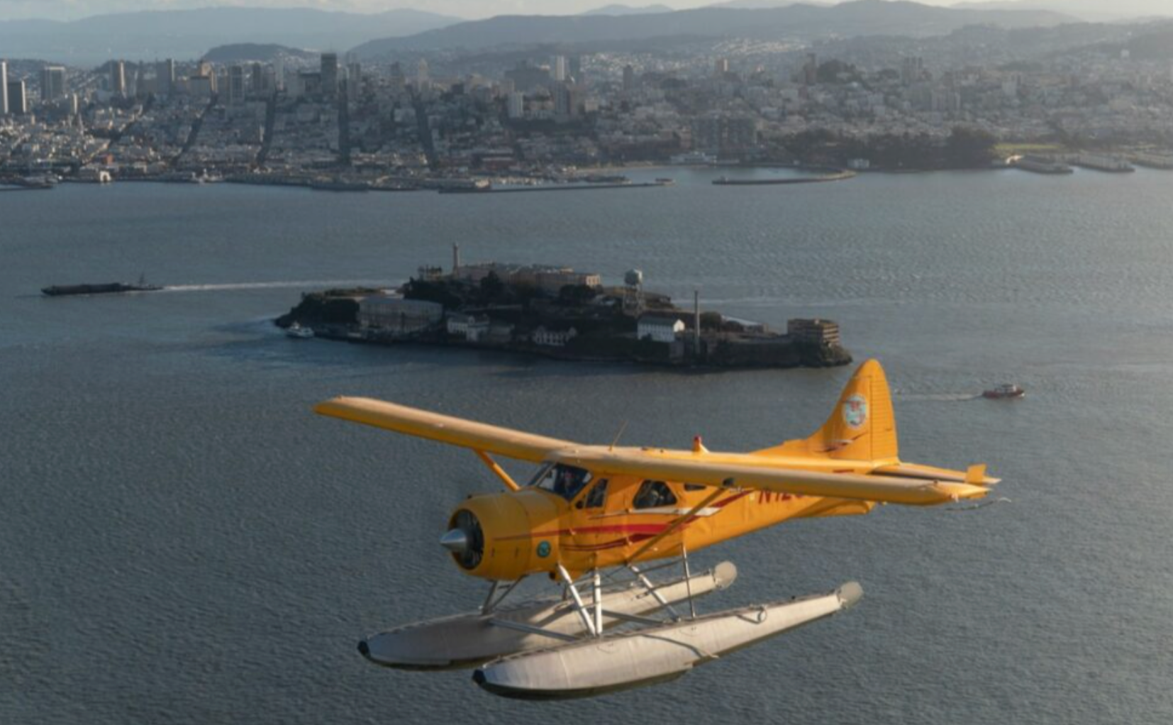
Crockett sits at a meeting of land and water where geography conspires to make flying compelling. From the air, the town's industrial silhouette—storied brick warehouses and the long lines of docks—becomes a pattern among salt marshes and shipping lanes. The Carquinez Strait acts as a natural corridor; its narrow waters funnel winds, create thermal complexity, and carve a visible path through the region that reads beautifully from a cockpit window. On clear days the view sweeps west to the glint of the Golden Gate and San Francisco skyline, east to the layered ridgelines of the East Bay and Mount Diablo, and north toward the vineyards of Napa and Sonoma. In short: Crockett is less about a single dramatic summit and more about an interplay of human and natural systems that translates exceptionally well to aerial perspective.
For travelers seeking airplane-based adventure, the area around Crockett offers variety: short scenic hops that last 20–40 minutes and are ideal for first-time flyers and photographers; longer coastal or inland circuits that can stretch an hour or more for deeper exploration; and the option to combine flights with other pursuits—an early-morning flight followed by a shoreline hike, an aerial photo session that frames refinery geometry with tidal flats, or a wine-country transfer that trades winding roads for straight-line efficiency. The scale of the Bay Area means pilots and operators often have several routing choices depending on weather, visibility, and airspace restrictions. Flightseeing reveals patterns invisible from the ground—tide lines that mark daily rhythms, the choreography of freighters threading the strait, and the microclimates that paint the hills in shifting light.
Practical considerations make Crockett a purposeful starting point. Nearby regional airports and aerodromes host flight schools, charter services, and tour operators, so options range from guided sightseeing to private charters for photographers or small groups. Unlike remote mountain landings or backcountry bush flying, airplane adventures here rely on established routes and coordination with controlled airspace in the greater Bay Area. That increases safety and accessibility but also means being flexible with scheduling: fog and low clouds common to the region can shift launch windows, and the strait's winds can introduce bumpy segments that are part of the local character. For independent pilots, the terrain is forgiving in terms of emergency alternatives—there are multiple nearby fields and sheltered waters—yet the density of air traffic and proximity to large commercial hubs make thorough planning and up-to-date briefings essential.
Culturally and historically, flight over Crockett layers the maritime and industrial past with contemporary recreation. Photographers and writers are drawn to the contrast between long-running human activity (docks, refineries, rail yards) and the living edges of wetlands and migratory birds. For families and travelers new to aviation, short sight-seeing flights provide a manageable, high-reward way to discover the Bay's geography without committing to a full-day itinerary. For pilots and aviation enthusiasts, the region offers complex flying that rewards careful planning: coastal thermals, variable winds through narrow straits, and routes that pass major landmarks and natural features in quick succession. The result is a versatile airplane-adventure hub—intensely visual, logistically accessible, and saturated with options to blend airborne perspective with boots-on-ground exploration.
The variety of airplane experiences near Crockett suits a wide audience—from brief aerial tours that prioritize views and photography to private charters that function as scenic transfers to Napa, San Francisco, or remote trailheads. Each offers a different relationship between time aloft and on-the-ground time, letting travelers balance novelty with practicality.
Seasonality matters: morning windows in late spring and summer often deliver the best visibility, while autumn can offer the clearest light for long-distance views. Conversely, marine layer and low overcast can close in suddenly; operators prioritize safety and will reschedule when conditions are marginal.
Best Time to Visit
Best Months
Weather Notes
Morning windows in spring and fall are often the clearest for visibility. Summer brings warmer air and the possibility of afternoon haze; winter can produce low marine layers that linger through mid-morning. Wind through the Carquinez Strait may create turbulence; pilots typically plan routing and altitudes to minimize bumpy segments.
Peak Season
Late spring through early fall when visibility and flight-frequency are highest.
Off-Season Opportunities
Winter and early spring can offer dramatic light, moody skies, and lower operator rates—if you can be flexible around fog and low clouds.
Frequently Asked Questions
Do I need a pilot's license to take part in these airplane experiences?
No—most airplane adventures for visitors are operated by licensed pilots and tour companies. If you intend to fly yourself in a rented aircraft, you must meet FAA licensing and currency requirements.
Will flights be canceled for fog or wind?
Yes. Operators prioritize safety and will postpone or reschedule flights when visibility or wind exceed safe operating limits. Morning bookings often give the best chance of flying.
How long are typical sightseeing flights from the Crockett area?
Sightseeing flights commonly range from 20 minutes for short scenic hops to 60–90 minutes for extended coastal or inland circuits. Duration varies by operator and desired routing.
Choose Your Experience Level
Beginner
Short, guided sightseeing flights designed for first-time flyers and casual travelers. Comfortable, minimal planning required—great for photography and a gentle introduction to aerial perspective.
- 20–30 minute bay overview flight
- Sunset scenic hop along the Carquinez Strait
- Introductory aerial photography session
Intermediate
Longer sightseeing circuits or private charters that require modest advance coordination. Good for travelers who want to pair a flight with a ground activity like hiking, boating, or winery visits.
- Hour-long coastal and inland circuit (views of Mount Diablo, shoreline, and shipping lanes)
- Charter transfer to a nearby regional airport followed by a guided hike
- Photography-focused flight with customized routing
Advanced
Flights that involve more complex planning, such as custom aerial photography missions, pilot-rated cross-country flights, or multi-leg charters. Requires experienced pilots, pre-flight planning, and coordination with airspace authorities.
- Custom aerial mapping or photography assignment
- Private charter linking multiple destinations (e.g., Crockett to Napa to Marin)
- Pilot-led advanced flight training in local airspace
Insider Tips & Local Knowledge
Always check weather and NOTAMs before booking. Allow extra time for check-in at small-field FBOs and for photography setup.
Book morning flights to maximize the chance of clear visibility and calmer winds. If you're shooting photos, request seats with the best view for your target landmarks and bring a wrist strap—open windows are rare in small planes, so plan for glass reflections and use a fast shutter speed. For travelers prone to motion sickness, choose shorter flights or take standard preventative measures a few hours before takeoff. Discuss routing preferences with the operator in advance—most will tailor brief routes to highlight requested features (bridges, shoreline, industrial geometry, or inland peaks) when conditions allow. Finally, pair your aerial outing with a shore-based plan: a post-flight coffee at a waterfront café, a short marsh walk, or a harbor boat trip extends the visual story you began from the air.
What to Bring
Essential
- Government photo ID (required for many charter operators)
- Layered clothing—cockpits and small cabins can be cool
- Camera with a fast lens and extra batteries
- Motion-sickness preventative if you’re prone
- Sunglasses with UV protection
Recommended
- Small, soft-sided bag (hard luggage is often restricted in small aircraft)
- Ear protection or airline-style earbuds for noise
- Portable mirrorless or DSLR with stabilized lens for sharp aerial shots
- Light windbreaker for pre- and post-flight on exposed ramps
Optional
- Notebook for flight logging and notes for photographers
- Binoculars for shoreline and birdwatching after landing
- Collapsible water bottle for sustainability
Ready for Your Airplane Adventure?
Browse 18 verified trips in Crockett with instant booking
Explore Top 15 Crockett, California Adventures →