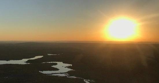
Air Tours in Carbondale, Pennsylvania — Scenic Flights & Aerial Views

Carbondale, Pennsylvania

Carbondale’s post-industrial valleys and wooded ridgelines read like a patchwork from above. Air tours here turn familiar landscapes — abandoned rail corridors, serpentine rivers, and coal-scarred hills — into layered textures you can only fully appreciate from the sky. Whether you’re after a short scenic hop or a tailored photography flight, the region’s compact topography and dramatic seasonal color make for rich aerial storytelling.

4
Activities
Spring–Fall
Best Months

Top Air Tour Trips in Carbondale

4 trips • Book with confidence • Instant confirmation

Why an Air Tour over Carbondale Reveals a Different Story

There’s a particular clarity to seeing Carbondale from a few thousand feet: the sinuous line of the Lackawanna River, the grid of streets that grew up around collieries, and the ridgelines that hem the town into a green-brown bowl in late summer. On the ground these features are discrete — a park, a railbed, a neighborhood — but from the air they layer into an ecological and human history that unfolds like a map. Pilots point out the scars and recoveries: strip pits that have softened into ponds, tipples that cast unexpected shadows, and rail corridors now repurposed for trails. For travelers curious about landscape transitions, industrial heritage, or simply wanting a compact taste of northeastern Pennsylvania’s terrain, an air tour compresses context and scenery into an elegant hour of perspective.

Air tours around Carbondale work especially well because the region’s landmarks are nearby and tightly spaced. Short flights can cross verdant hills, follow river corridors, and spiral over old mining sites without long transit time — which makes options accessible for half-days on a weekend itinerary. Seasonality plays an outsize role in what you’ll see: the late-summer palette leans into ochre and slate; autumn brings high-contrast color that looks cinematic from a plane; spring opens wetlands and rekindles the green veins along the rivers. Weather and light are crucial drivers of a memorable flight, so photographers and contemplative travelers alike will plan for clear mornings or low-angle afternoon light.

Beyond the visual payoff, an air tour can sharpen how you plan the rest of your trip. Many operators will frame flights around complementary land experiences — a riverside paddle to follow a corridor you first observed from above, a rail-trail ride that tracks an old coal spur, or a sunrise drive to a ridge you glimpsed during the flight. The aerial view also reframes practical considerations like orientation, access, and the lay of the land: where to stage hikes, where scenic overlooks cluster, and how seasonal water levels shape both river trips and wetlands in the valley. For travelers who love context with their scenery, an air tour over Carbondale is less about spectacle and more about seeing the ecological and cultural threads that stitch the landscape together.

Air tours here are typically short, locally focused flights rather than long cross-country legs; that makes them an efficient way to add a dramatic vantage point to a day of hiking, history, or paddling.

Operators may offer fixed-wing scenic flights, helicopter hops, or specialty charters for photography — each platform has trade-offs in access, stability, and cost.

Best results come with flexible scheduling: book around morning calm or late-afternoon light, and expect cancellations during low clouds, high winds, or active frontal systems.

Activity focus: Short scenic flights and aerial photography
Ideal for seasonal color, industrial-heritage views, and compact landscape overviews
Typical flights are local hops (30–90 minutes) rather than long-distance tours
Weather and light have an outsized effect—plan for morning calm or golden-hour light
Complementary activities: rail-trail rides, river paddling, heritage museum visits

Best Time to Visit

Best Months

AprilMayJuneSeptemberOctober

Weather Notes

Calm, clear mornings in spring and fall provide the most comfortable flying conditions and the cleanest light for photography. Summer can produce thermals and afternoon storms; winter flights are possible on clear days but face more frequent cancellations.

Peak Season

Autumn leaf season (mid-September through October) draws the highest demand for scenic flights and photographic charters.

Off-Season Opportunities

Winter weekdays sometimes provide clear-air visibility and low traffic, but expect limited operator schedules and a higher chance of weather-related cancellations.

Frequently Asked Questions

Do I need flying experience to take an air tour?

No. Air tours are designed for passengers with no flying experience. Operators provide safety briefings and usually brief passengers on seating, headset use, and camera handling.

Are flights canceled for cloudy or windy days?

Yes. Low clouds, poor visibility, high winds, or active frontal systems can prompt cancellations for safety reasons. Operators will typically reschedule or refund based on their policies.

Can I bring a camera and photograph during the flight?

Yes. Most operators allow photography from the cabin. Use a secure strap, avoid large lens changes mid-flight, and ask the pilot about open-door or door-off options before booking (those require specialized aircraft and permissions).

How accessible are air tours for people with mobility concerns?

Accessibility varies by aircraft type. Smaller aircraft may require climbing a short step; discuss mobility needs with the operator in advance so they can advise on suitability and any accommodations.

Choose Your Experience Level

Beginner

Short scenic hops that introduce the landscape without requiring prior experience—ideal for first-time flyers and families.

  • 20–30 minute valley circuit to view the Lackawanna River corridor
  • Introductory round-trip flight over local ridgelines

Intermediate

Longer flights or themed routes that focus on seasonal color, industrial heritage, or a mix of river and ridge vistas; suitable for casual photographers and curious travelers.

  • 45–60 minute scenic tour combining river corridors and former mining sites
  • Photographic flight timed for golden hour

Advanced

Specialized charters for aerial photographers, survey work, or door-off helicopter sessions—these require coordination, experience with aerial shooting, and flexible scheduling.

  • Tailored aerial photography session with pilot coordination
  • Survey or mapping-style charter for focused landscape study

Insider Tips & Local Knowledge

Confirm logistics with your operator, watch the weather, and match flight timing to light and wind conditions.

Book morning flights for calmer air and crisper visibility; late-afternoon light yields warm tones but can be bumpier as thermals develop. Ask operators about window-seat preferences and whether they provide headsets—headsets improve communication and reduce fatigue during the flight. If photography is a priority, request a seat with the best view for your intended targets and bring a mid-range zoom to cover both wide landscapes and tighter details. Combine an air tour with a ground excursion: follow a rail-trail you first observed from the sky, or time a river paddle to trace a corridor you flew along. Finally, allow flexibility in your schedule—weather can move a flight by a day, and that extra window often makes the difference between a washed-out snapshot and a memorable aerial view.

What to Bring

Essential

  • Valid photo ID (required by many air operators)
  • Weather-appropriate layers—cockpits can be cooler and windier
  • Camera with a secure strap and a mid-range zoom (24–200mm)
  • Sunglasses and sun protection for pre-/post-flight time

Recommended

  • Ear protection or lightweight noise-cancelling earbuds (operators may supply headsets)
  • Small daypack for ground activities paired with the flight
  • Motion-sickness remedies if you’re prone to airsickness
  • Extra memory cards and spare batteries for photography

Optional

  • Binoculars for pre-flight scouting on the ground
  • Polarizing filter to reduce glare on rivers and ponds
  • Light tripod or monopod if planning a helicopter photography session

Ready for Your Air Tour Adventure?

Browse 4 verified trips in Carbondale with instant booking

Explore Top 15 Carbondale, Pennsylvania Adventures →