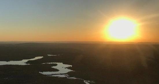
Air Tours in Albrightsville, Pennsylvania
Perched amid the rolling crests and lake-stippled valleys of the southern Poconos, Albrightsville is a low-key launch point for short scenic flights that translate the region’s patchwork of forests, ski slopes, and kettle lakes into cinematic panoramas. Air tours here range from quick sightseeing hops that reveal fall foliage and frozen lakes to longer photo-focused charters that trace ridgelines, glacial valleys, and the serpentine courses of the Lehigh River.
Top Air Tour Trips in Albrightsville
4 trips • Book with confidence • Instant confirmation
Why Take an Air Tour Over Albrightsville
From the ground, the Poconos can feel intimate: a stand of hardwoods here, a glacial lake there, ski slopes cut into the forested spine of a ridge. From the air, those pieces snap together into a landscape that reads like a map come alive. An air tour over Albrightsville turns discreet local features into a coherent geography—crystalline lakes ringed by cottages, highways threading through wooded hollows, and the ragged blue line of ridgelines that mark watershed divides. The light in spring and fall is particularly kind; low-angle sun scours the small relief of the land and highlights shoreline patterns and rock exposures that are easy to miss at eye level.
These flights also offer a swift primer in the region’s natural and cultural history. From above you can make out the scars and seams left by past extractive industries, the geometric imprints of ski runs and reservoirs, and the patchwork of second-home developments that cluster around summer lakes. Pilots often point out landmarks—Hickory Run State Park’s boulder fields, the broad mirror of Lake Harmony, the ridgelines used by winter sports operators—and explain how local weather and topography interact. That context turns a short flight into a richer story: not just a view, but an orientation to landscape, season, and the ways people use these mountains.
Practically, an air tour is one of the most time-efficient ways to see the Poconos. A 20–45 minute flight compresses what could be a day of driving and hiking into a single golden-window experience. That makes air tours excellent complements to other activities: photographers can scout overlooks, kayakers can pinpoint backwater coves for quieter afternoons, and ski visitors can get a sense of the valley pattern before picking a run. For travelers who savor a clear visual reference to the land they’re crossing, the aerial perspective acts like a travel enhancer—informing decisions on hikes, paddle routes, and even where to chase sunset light on the drive back to base.
Short flights are ideal for first-timers and families; longer charters suit photographers or travelers who want to stitch multiple features—lakes, ridges, and river valleys—into a single mission.
Weather matters: visibility, wind over ridges, and low cloud decks are the typical constraints for operators in this region. Pilots will often reschedule for clearer windows when possible.
Air tours pair well with ground activities—consider booking a morning flight for soft light and then an afternoon hike, paddle, or scenic drive to stay in the same light for photography.
Best Time to Visit
Best Months
Weather Notes
Late spring and early summer bring stable visibility and moderate winds. Fall (September–October) offers the region’s most dramatic colors and frequently calm mornings; summer afternoons can generate convective clouds and brief storms. Winter flights are possible on clear days but often face cancellations due to low ceilings, snow, or ice.
Peak Season
September–October (fall foliage and peak demand for scenic flights)
Off-Season Opportunities
Winter can yield crisp air and sharp visibility on clear days; operators and private charters sometimes offer discounted or flexible scheduling during quieter months.
Frequently Asked Questions
Do I need any permits for a sightseeing flight?
No special permits are required for passengers. Operators hold FAA certifications; ask your provider about ID and luggage restrictions before arrival.
Are air tours suitable for children and seniors?
Most short scenic flights are family-friendly. Inform the operator of any mobility or medical needs; weight-and-balance rules may limit seating arrangements for very young children or passengers requiring extra assistance.
What happens if the weather is bad on the day of my flight?
Operators typically offer rescheduling or refunds for weather cancellations. Because mountain weather can change quickly, expect flexible booking policies and confirm the operator’s terms when you book.
Can I bring a camera or drone?
Handheld cameras are standard. Drones are regulated by the FAA and are generally not allowed to be operated from a manned aircraft; coordinate drone use with local rules and separate ground-based flights.
Choose Your Experience Level
Beginner
Short, low-altitude sightseeing flights—designed for passengers with little to no flight experience and minimal preparation required.
- 20–30 minute lake-and-lodges scenic hop
- Introductory ridgeline overview focusing on nearby state parks
- Sunset sampler flight with pilot narration
Intermediate
Longer flights that cover multiple geographic features, timed for light and photography, and occasionally arranged as custom charters.
- 45-minute photo-focused tour of Lake Harmony, Hickory Run, and surrounding ridges
- Aerial orientation before a multi-day kayaking or hiking itinerary
- Seasonal foliage circuit with stopover planning assistance
Advanced
Specialized charters for aerial photographers, survey work, or multi-leg missions that require planning, custom routing, and coordination with operators.
- Full-day charter stitching valleys and ridgelines for professional photo shoots
- Aerial survey or mapping sortie coordinated with a private pilot
- Custom sunrise-to-sunset photography mission with multiple takeoffs and landings
Insider Tips & Local Knowledge
Book early for fall windows, choose your seat with purpose, and build flexibility into your schedule for weather shifts.
Seats matter: on many small aircraft, one side will have clearer views of a given route—ask the operator which side to request for the best lake or ridgeline views. Early-morning flights often have the calmest air and the softest light; sunset flights can be dramatic but may encounter thermals or gusts depending on conditions. Communicate photography goals when booking so pilots can tailor routes and altitudes where safe and permitted. Expect operators to enforce weight-and-balance limits; if you’re traveling with heavier camera gear, mention it in advance. Finally, treat the flight as part of a larger day of exploration—pair it with a lakeside picnic, a guided hike in Hickory Run State Park, or a post-flight coffee at a local lodge to extend the view from the air to the ground.
What to Bring
Essential
- Government-issued photo ID (check operator requirements)
- Camera with a fast shutter and a stabilized lens
- Layered outerwear—cockpit temps can feel cooler than on the ground
- Sunglasses for glare reduction
- Any necessary motion-sickness medication
Recommended
- Compact telephoto or wide-angle lens and extra batteries/memory cards
- Noise-cancelling or in-ear headphones if provided by the operator
- Light backpack or soft bag (rigid luggage sometimes restricted)
- Smartphone with offline map or notes for landmark reference
Optional
- Binoculars for post-flight viewing on shorelines or ridgelines
- Small notebook for jotting pilot notes about photo angles and landmarks
- Light gloves for chilly dawn or sunset departures
Ready for Your Air Tour Adventure?
Browse 4 verified trips in Albrightsville with instant booking
Explore Top 15 Albrightsville, Pennsylvania Adventures →