Skip to main content
A Cascade of Wonders: Bonita Falls
Explore Bonita Falls, a 90-foot waterfall in San Bernardino National Forest. This moderate hike offers wildlife viewing and photography opportunities. Ideal for a natural escape with serene views and sounds of nature along the way.
Hiking Trail Bonita Falls
•8.2/10
•Moderate
A Cascade of Wonders: Bonita Falls
Category
Hiking
Typical Duration
30-40 minutes
Difficulty
Moderate
Photo Gallery
A Cascade of Wonders: Bonita Falls - Hiking Trail Bonita Falls
A Cascade of Wonders: Bonita Falls - Hiking Trail Bonita Falls
A Cascade of Wonders: Bonita Falls - Hiking Trail Bonita Falls
About This Landmark
Stunning Waterfall Hike at Bonita Falls, Lytle Creek
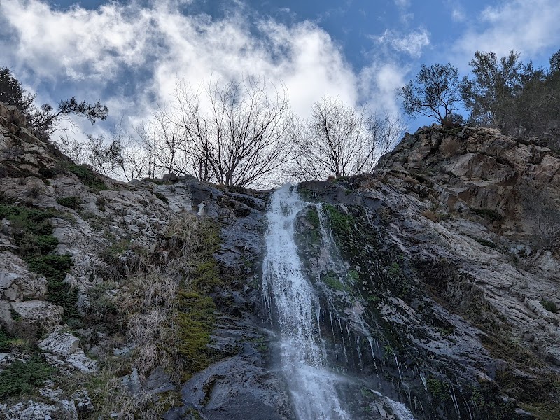
Hiking Trail Bonita Falls is a remarkable outdoor destination located in the San Bernardino Mountains near Lytle Creek, California. This trail leads visitors to one of Southern California’s tallest waterfalls, which drops over 90 feet in a dramatic cascade. Its impressive height and lush surroundings make Bonita Falls stand out from other hikes in the region. The falls themselves are framed by rugged cliffs covered in vibrant mosses and native chaparral plants, creating a refreshing green contrast that changes with the seasons.
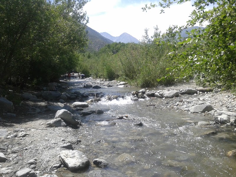
The trail spans approximately 1.5 miles one way and winds alongside a lively mountain stream. It begins at a campground parking area and crosses rocky pathways before following the water upstream. Hikers experience varied terrain that includes smooth creekside paths and a steeper ascent near the falls. Mature sycamore trees offer shade, while panoramic views of the canyon provide scenic breaks along the climb. Wildlife sightings are common, with local birds and small mammals adding to the natural atmosphere.
Historically, the area around Bonita Falls once served as a travel route for indigenous tribes long before modern roads arrived. Today, the park remains a beloved spot for families and outdoor enthusiasts who appreciate its peaceful ambiance despite its accessible location near urban centers. Photographers especially enjoy capturing the waterfall’s mist and shifting light patterns on the rock face.
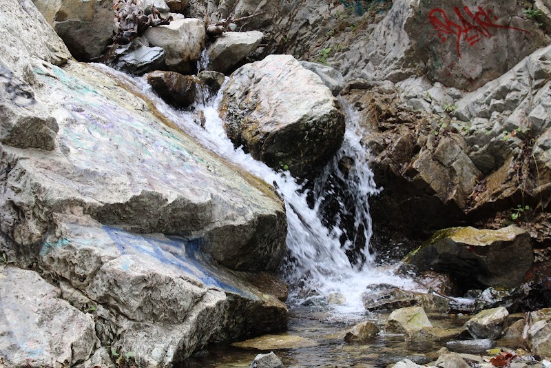
Visitors are encouraged to respect the environment here, as some areas have been affected by graffiti and litter. Still, the trail delivers a rewarding blend of natural beauty and moderate adventure, making Bonita Falls a unique and memorable destination for hikers and nature lovers along the San Bernardino National Forest corridor.
Adventure Guide To Hiking Trail Bonita Falls
Trail Hiking Near Lytle Creek
Bonita Falls trail offers a short, moderate hike of about 3 miles roundtrip, perfect for families and casual hikers looking for a refreshing mountain walk. The steepest section appears near the upper canyon as you approach the waterfall, rewarding hikers with stunning water views and a cool, misty atmosphere.
- Key Features: Flowing creek, steep rocky sections, sycamore groves, 90-foot waterfall
- Visitor Tip: Use the spray-painted rocks as trail markers, but be mindful to stay on designated paths to protect the habitat. Bring sturdy footwear for uneven terrain.
Picnicking & Nature Spotting
Near the trailhead and along the path, there are picnic areas where families can enjoy meals amid forest surroundings. The presence of native chaparral blooms and local bird species make this an excellent spot for casual wildlife watching.
- Amenities: Picnic tables, propane grills in designated areas, portable restrooms
- Local Insight: Water levels vary by season, so your experience by the falls can range from thin trickles to a full cascade during wetter months.
Access & Practical Info
The trail is accessed from a campground area within the San Bernardino National Forest, just outside Lytle Creek, California. Parking requires a Forest Adventure Pass ($20 daily), available for purchase at nearby retailers or ranger stations.
- Best Time to Visit: Spring through early fall for best water flow and cooler weather
- What to Bring: Water, sunscreen, insect repellent, sturdy shoes, and a camera
- Directions: From nearby highways, follow signs to Lytle Creek and head toward the campground area; the hike starts on the opposite side past the creek rocks. Expect about 30-40 minutes driving from Inland Empire urban centers.
While some visitors note issues with graffiti and litter, many appreciate the quiet natural beauty and family-friendly vibe that makes Bonita Falls a worthwhile destination in Southern California’s mountainous landscape.
Adventure Guide to Hiking Trail Bonita Falls
Must-Experience Activities
-
Hiking to Bonita Falls
- What Makes It Special: A moderately easy hike leading to one of the tallest waterfalls in Southern California.
- Key Features: Dense forest sections, small streams, and a photogenic scenic view upon arrival.
- Local Insights: Look for the vibrant algae and moss which flourish where sunlight meets the mist.
-
Wildlife Observation
- What Makes It Special: The area is teeming with Southern California fauna, including foxes and diverse bird species.
- Key Features: A good pair of binoculars or a camera will enhance your experience.
- Visitor Tips: Mornings and late afternoons are prime times for animal activity.
-
Picnicking at the Falls
- What Makes It Special: Offers a peaceful area for relaxation, surrounded by the soothing sound of the falls.
- Visitor Tips: Bring a waterproof blanket and snacks.
Visitor Tips
- Best Times to Visit: Late winter to early spring, when the waterfall flows strongest.
- What to Bring: Sturdy shoes, snacks, water, camera, and sun protection.
- Directions: From Lytle Creek, follow the moderately marked trails towards Bonita Falls; the hike typically takes about 2 hours round-trip.
Ratings
Overall
8.2/10User rating
Photography
8.0/10Scenic value
Featured Activities
Primary Activity
Hiking
Also Great For
Photography
Wildlife Observation
Picnicking
Essential Information
Nearby City
Lytle Creek, California
Protected Areas
San Bernardino National Forest
Experience Level
Moderate
Experience Needed: This natural landmark is recommended for those with some outdoor experience. Good for regular hikers.