Cruising the Talimena Scenic Drive: Fall Foliage’s Boldest Display in Talihina, Oklahoma
The Talimena Scenic Drive offers a clear window into one of Oklahoma's most vivid fall experiences. Stretching through the Ouachita Mountains, it’s a curated adventure of vibrant colors and sweeping vistas, perfect for travelers seeking both ease and excitement in their autumn escapes.
Time Your Drive for Fall Color Peak
Plan your trip between mid-October and early November to catch the foliage at its brightest and avoid summer crowds.
Pack Layered Clothing
Temperatures vary along the ridge—mornings can be chilly while afternoons warm up—so layers help you stay comfortable throughout the day.
Fuel Up Before Departing Talihina
Gas stations are limited along the drive, so start with a full tank to avoid interruptions on this remote route.
Use Safe Footwear for Trail Stops
If you plan to hike trails such as the Winding Stairs, sturdy shoes with good tread are necessary to navigate uneven terrain safely.
Cruising the Talimena Scenic Drive: Fall Foliage’s Boldest Display in Talihina, Oklahoma
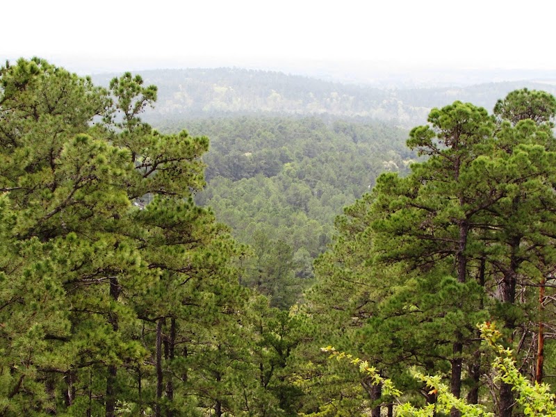
Stretching 54 miles along the crest of the Ouachita Mountains, the Talimena Scenic Drive is an invitation to witness fall’s vibrancy from behind the wheel. As you steer eastward from Talihina, Oklahoma, the road unfurls like a ribbon hemmed with trees flaunting bright reds, golds, and oranges. This Highway 1, a National Scenic Byway, is not just a drive—it’s a journey through a landscape fiercely alive with color and character.
The road traces ridge lines at elevations hovering between 2,000 and 2,500 feet, placing you above valleys where rivers dare you with their steady currents below. Every pullout offers a chance to step out and feel the cool, crisp air teasing your skin, to listen as the brisk wind breathes through the littered forest floor, challenging you to slow down and absorb the moment.
Planning ahead is key: the drive is best undertaken between mid-October and early November when the foliage reaches its peak. Morning light brings out the shadows and depth in the hills; afternoons make the colors blaze with warmth. Starting early means fewer cars and quieter outlooks.
For those eager to stretch legs, several trails pepper the route, like the Winding Stairs Trail, a 3.5-mile trek that tests legs with a 1,500-foot elevation gain but rewards hikers with panoramic views where trees stand like sentries in fire-hued robes. Footwear with solid tread and layering for changing temperatures are practical musts.
Essential supplies? Water in insulated bottles to fend off the unpredictable chill, a charged phone for navigation, and a full tank—gas stations are scarce along this ridge road. Take your time; the landscape demands respect and attention, not speed.
Driving the Talimena during fall is a mix of leisure and alertness: curves tighten and elevation shifts beneath your wheels. Each bend invites a new vista and a fresh sensation of being suspended between sky and wooded valley floor. The forest around you is not merely backdrop — it’s a living presence, urging quiet appreciation.
Conclude at the Zigzag Scenic Overlook, where you can pause on a deck edge that peers into the valley and watch as the sun slips lower, setting the forest ablaze once more. Here, the journey blends thrill and practicality, an accessible adventure designed for anyone ready to meet the season’s fierce beauty head on.
Nearby Trips
All Adventures
Boat Charters
Water Activities
Adventures near Talihina, Oklahoma
Discover the unique and memorable adventures that make Talihina, Oklahoma special.
Frequently Asked Questions
How long does it take to drive the entire Talimena Scenic Drive?
Driving the full 54 miles usually takes about 2 to 3 hours when factoring in stops for sightseeing and short hikes. Without stops, the drive is roughly 1.5 hours, but this misses the essential experience.
Are there places to eat or refuel along the drive?
Options are very limited directly on the drive. It’s best to fuel up and stock snacks in Talihina before you begin. There are picnic areas but no restaurants along the route.
Is the Talimena Scenic Drive open year-round?
Yes, but winter conditions like ice or snow can occasionally close portions of the road. Always check weather and local updates before traveling in winter.
Can I hike the trails along the Talimena Drive?
Yes, several trails like the Winding Stairs offer moderate hikes with rewarding views. Trails vary from easy walks to more challenging climbs, so choose based on your fitness and experience.
What wildlife might I see along the route?
White-tailed deer, wild turkey, and a variety of songbirds are common. Early mornings and late afternoons increase chances of spotting animals moving through these ancient forests.
Is the route family-friendly?
Definitely. The drive itself is accessible to all ages. Some hiking options might be better suited for older children or adults due to elevation changes and trail length.
Recommended Gear
Layered Clothing
Adjust for temperature swings—cool mornings and warm afternoons demand flexibility.
Hydration Pack or Water Bottles
Carry enough water to stay hydrated during hikes or scenic stops; the crisp mountain air dries you out quicker.
Good Hiking Shoes
Necessary for short hikes and lookout points with uneven, sometimes rocky terrain.
Camera or Smartphone with Extra Battery
Capture the intense colors and sweeping views; cold weather drains batteries fast, so bring extras.
Local Insights
Hidden Gems
- "Bee Rock Overlook offers fewer visitors and striking eastward views of dense forest hills."
- "Silent Breezes Trail loop, just off the main drive, provides peaceful woodland immersion away from crowds."
Wildlife
- "Red foxes patrol the wooded edges at dusk, often unseen but audibly present."
- "Eastern wild turkeys are frequent and add dynamic movement to the forest floor."
History
"The Talimena Scenic Drive follows historic ridge trails once used by Indigenous peoples and early settlers navigating the Ouachita Mountains. The area also has deep cultural ties to the Choctaw Nation, whose lands border the route."