Backpacking the Ouachita Trail: Remote Ridges and Hidden Streams in Oklahoma
The Ouachita Trail in Oklahoma offers backpackers a rugged escape into remote ridges and whispering streams, providing a rich mix of solitude and natural beauty. Perfect for adventurers seeking a balance between challenge and tranquility, this section invites careful planning and respectful engagement with the wild.
Carry Adequate Water Supplies
Streams can fluctuate or run low, especially in late summer. Bring a minimum of 2 liters per day and a reliable water filter or purification tablets for on-trail sources.
Wear Rugged, Supportive Footwear
The trail’s rocky and root-strewn terrain demands durable boots with solid ankle support; trail runners may struggle with stability on uneven ground.
Plan for Variable Weather
Early spring and fall can hold sudden temperature swings. Dress in layers to adapt quickly and pack a lightweight rain jacket for sudden storms.
Start Early to Maximize Daylight
The trail’s remote sections can slow your pace. Begin hikes at dawn to cover more ground safely and avoid navigating in the dark.
Backpacking the Ouachita Trail: Remote Ridges and Hidden Streams in Oklahoma
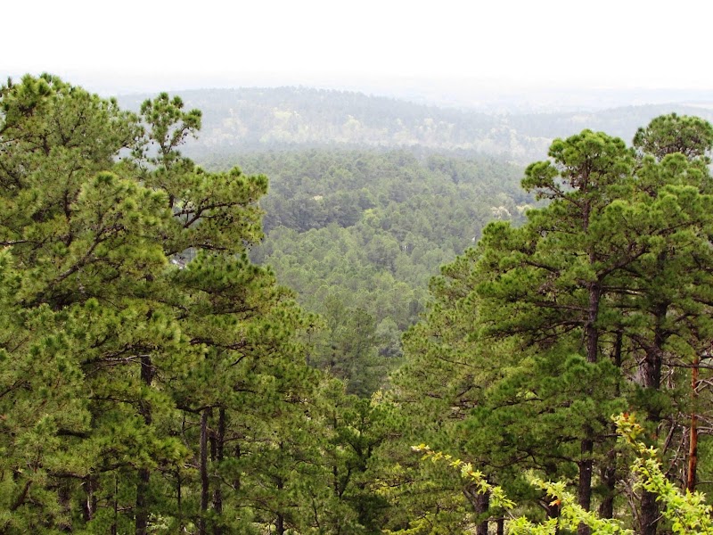
Stretching over 223 miles from Talimena State Park, Oklahoma, to Pinnacle Mountain, Arkansas, the Ouachita Trail invites backpackers into a rugged world where thick forests cling to rocky ridges and streams weave through canyon bottoms like secret veins. In Oklahoma’s section, expect about 60 miles of solitude punctuated by undulating hills and creek crossings challenging your footing. This trail is no idle stroll; it demands steady legs and alert senses as the terrain rises and falls with the Ouachita Mountains—reminding you that nature here is fiercely itself.
The wooded path pulses with life. Oaks and hickories stand firm, leaves whispering above while hidden streams dare you to step closer. Seasonal bursts of color shift the landscape dramatically, from the fresh green of spring to the fiery glow of fall, each offering its own motivator to take that next mile. Elevation gains hover around 300 to 600 feet repeatedly, testing endurance without overwhelming. The trail’s surface mingles dirt, rocks, and occasional roots, urging solid hiking boots with dependable traction.
Water sources punctuate the journey, but their flow can vary; plan to carry ample hydration or treat water from streams. Campsites are spaced near springs or clearings, giving chances to rest beneath the stars’ steady gaze. While the Ouachita may stretch long, Oklahoma’s stretch rewards hikers with quiet removal from crowds and a rich interplay of creek song and ridge views.
Travel light but prepared: layered clothing meets changing temps, insect repellent wards off mosquitoes, and a reliable map or GPS helps navigate the more isolated sections. Early spring or mid-fall offer optimal conditions—avoid summer’s oppressive heat and winter’s occasional icy grip to keep the adventure smooth.
This trail doesn’t just ask you to walk through it; it engages you, demanding attention to every step, every sound, every shift in light. It’s a place where nature shows its sharp edges alongside moments of tranquil grace, perfect for those ready to earn their experience under an open sky.
Nearby Trips
All Adventures
Boat Charters
Water Activities
Adventures near Talihina, Oklahoma
Discover the unique and memorable adventures that make Talihina, Oklahoma special.
Frequently Asked Questions
How accessible is the Ouachita Trail’s Oklahoma section for beginners?
While the trail is well-marked and maintained, the terrain varies with consistent elevation changes. Beginners with good fitness and basic hiking experience can complete sections by planning shorter daily distances and focusing on preparation.
Are there reliable water sources on the trail?
Yes, intermittent streams and springs appear along the route, but their flow depends on season and rainfall. Carrying enough water and purification equipment is essential to stay hydrated safely.
What wildlife might I encounter?
Expect white-tailed deer, wild turkeys, and various songbirds. The area also hosts occasional black bears and venomous snakes like copperheads, so awareness and respectful distance are key.
Is camping allowed along the trail?
Designated campsites exist, often near water sources, but dispersed camping is permitted in most areas. Use Leave No Trace principles to minimize impact.
When is the best time to hike the trail to avoid crowds?
Early spring and late fall typically see fewer visitors, allowing for greater solitude and peaceful hiking conditions.
Are there any permits or fees required for hiking this trail section?
No permits are necessary just to hike the trail in Oklahoma, though parking fees may apply at some trailheads or parks.
Recommended Gear
Hiking Boots
Provides stability and protection on mixed rocky and root-covered trails.
Water Filtration System
Enables access to natural water sources safely along the trail.
Layered Clothing
Allows for quick adjustment to varying temperatures and weather conditions.
Headlamp
Crucial for early starts, late finishes, or unexpected delays on the trail.
Local Insights
Hidden Gems
- "The Summit Trail viewpoint near Caption Mountain offers less-trafficked panoramic views of layered ridges."
- "Hidden cascade pools on Winding Stair Creek provide refreshing stops away from main campsites."
Wildlife
- "Watch for elusive red salamanders along shaded creek bottoms."
- "Keep an eye out for pileated woodpeckers whose distinct drumming resonates through the forest."
History
"Parts of the Ouachita Trail trace routes once used by Native American tribes and early settlers, preserving cultural landmarks like ancient stone walls and historic homesteads in the forest."