
What the day feels like
The morning light at Bourke's Luck Potholes slices across the canyon like a clean knife, catching the rims of stone cups that look almost engineered. You stand on a metal boardwalk above a swirl of polished rock and green water, watching eddies that have been patiently drilling their circles for millennia. The air smells faintly of damp earth and eucalyptus from the escarpment plateau; somewhere downstream the Blyde River chuckles and dares you to linger. This is not a waterfall or a summit; it is an invitation to read time in stone.
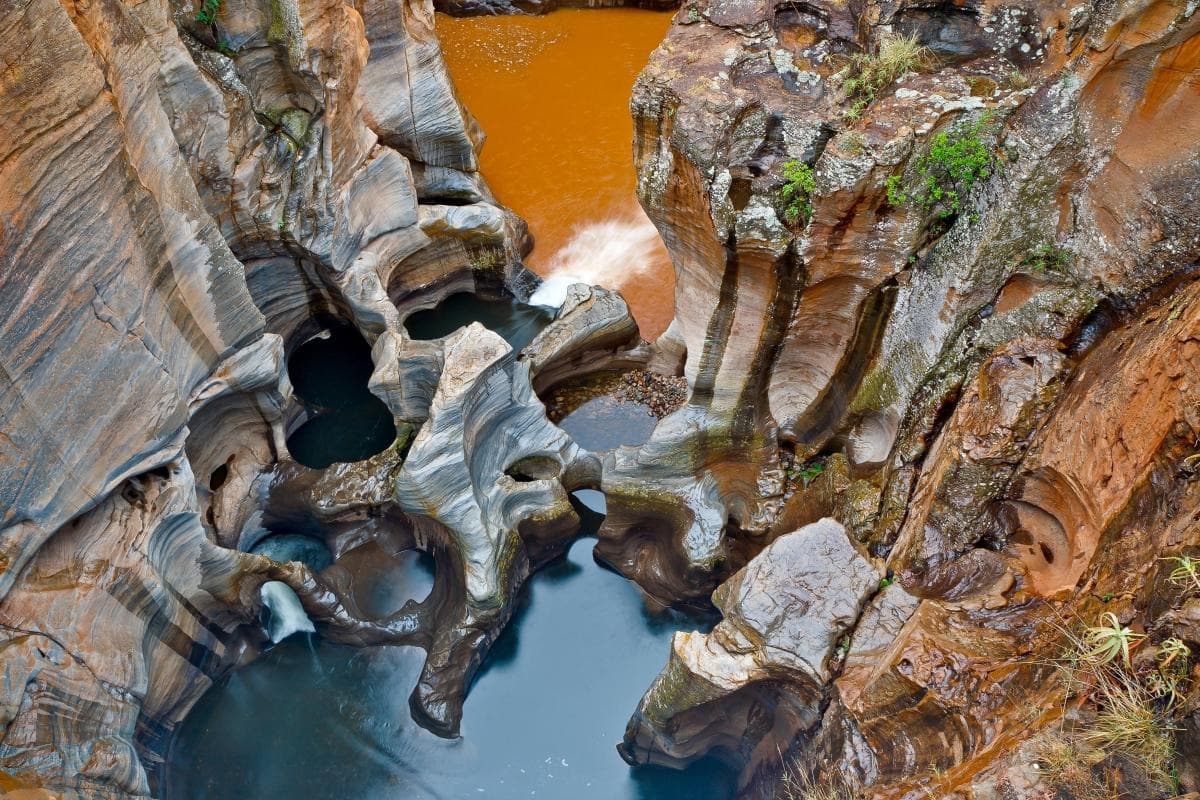
Located on the Panorama Route in Mpumalanga, Bourke's Luck Potholes are a study in patient erosion — a place where two rivers, the Treur and the Blyde, meet and spin sediment into cylindrical cavities, some several metres deep. The result is a field of sculpted, honey-toned rock, threaded with pools and narrow channels, and framed by the green teeth of the Blyde River Canyon beyond. Walk the short loops and viewpoints and you find yourself constantly reorienting: a pothole looks like a geological amphitheater from above, a marbled bowl from the rim, and a glassy micro-lagoon from the path down.
The area sits on the edge of the Lowveld escarpment; the wider panorama includes God’s Window and the Three Rondavels, the other stars of the Panorama Route that together explain why drives through this part of South Africa feel like a succession of perfectly framed landscapes. The name “Bourke's Luck” has its own bit of human drama — named after a 19th-century prospector, Tom Bourke, whose “luck” in searching for gold here was mixed at best. His story, like the place itself, is a reminder that this landscape has always been a place of both work and wonder.
Geologically, the potholes are textbook: whirlpools formed by the confluence of rivers carrying pebbles that grind and gouge softer rock into the cylindrical shapes you see today. Over time the rock’s strata and mineral bands have produced the concentric rings and marbling that make each pothole visually complex — the pattern is as much a record of changing flow as it is of composition.
Visiting Bourke's Luck is less about a long hike and more about attentive movement. The designated paths and boardwalks loop close to the edge, with a series of interpretive plaques that point out how the rivers sculpted this place and how humans have used it — from early gold prospecting to the present-day nature reserve. Nearby Graskop and Hazyview function as practical bases, with Graskop's pancake cafes and craft stalls offering a friendly contrast to the quiet, prehistoric feel of the rocks.
Practicalities are simple but worth planning. The site is managed as part of the Blyde River Canyon Nature Reserve; expect a short walk from the parking area (generally under 1 km round trip along a mix of level boardwalk and stepped stone paths). Total elevation change on the immediate loops is modest — under 50 metres — so most visitors manage easily, but there are steps and some uneven surfaces that reward sturdy footwear and a steady pace. Peak light for photos is morning or late afternoon when the water reflects colour and the shadows deepen the potholes’ contours; midday sun flattens the textures.
If you’re combining Bourke's Luck with a Panorama Route day, plan also for God’s Window, the Three Rondavels, and Lisbon Falls — each viewpoint is within a short drive and strikes a different geological note. Local stops like Harrie's Pancakes in Graskop make excellent lunch breaks and highlight how tourism here folds into small-town life. Many visitors arrive on half- or full-day tours from Hazyview or Johannesburg; independent travelers should budget 1–3 hours to properly walk the loops, scan the canyon, and linger with a cup of coffee.
Safety and conservation are straightforward: stay on signed paths, don’t climb the pothole rims, and pack out what you pack in. Wildlife here is subtle — vervet monkeys and birdlife are common around the edges; sightings of larger animals happen in the wider canyon but are rare at the potholes themselves. Respect for the site’s fragile vegetation and geological features keeps it vivid for the next visitor.
For a traveler who loves compact experiences with big, readable payoff, Bourke's Luck Potholes is an essential stop on the Panorama Route. It’s a place that rewards a slow look: you learn to read the water, the stone bands, the polished lips of each pothole. It is quiet proof that landscapes keep their own calendars and that, in this particular corner of Mpumalanga, the rivers have chosen to write in perfect circles.
Trail wisdom
Small choices, better day.
Time your light
Visit early morning or late afternoon for the best shadows and reflections in the potholes and to avoid the harsh midday glare.
Wear grippy shoes
Paths include metal boardwalks and uneven stone steps; closed-toe shoes with decent tread reduce slip risk.
Respect the edge
Stay on marked boardwalks — the rims are unstable and the rock drops into deep, fast water.
Combine with the Panorama Route
Pair the potholes with God’s Window, Three Rondavels and Lisbon Falls for a full-day circuit from Hazyview or Graskop.
Local knowledge
Read the place, not just the route.
Watch for native species including Vervet monkeys, Fish eagles and other raptors over the canyon.
Keep an eye out for wildlife during the transition between areas and habitats. Respect distance guidelines.
Managed within the Blyde River Canyon Nature Reserve, the site uses boardwalks and signage to limit erosion and protect riparian vegetation; visitors are asked to stick to paths and avoid disturbing wildlife.
Follow the guide's instructions on size limits, ethical handling, and leave-no-trace practices.
Walk the short, shaded trail to Lone Creek Falls 20–30 minutes south of Graskop. Browse Graskop’s craft stalls and try Harrie's Pancakes for a hearty local lunch
Locally recommended viewpoints and quiet spots known best to local operators.
Named after prospector Tom Bourke, the potholes also mark a stretch of the Panorama Route that has long been a corridor for prospectors, farmers and travelers.
Maritime roots and regional tradition shape the waterways and working coasts.
Seasonal guide
Four versions of the same landscape.
Spring
Best forwildflowers · fewer crowds · comfortable walks
Challengesafternoon thunderstorms · variable visibility
September–November brings warming temperatures, blooming fynbos pockets and manageable walking conditions, though short showers are possible.
Summer
Best forlush river flow · dramatic skies · butterfly and bird activity
Challengesheavy rains · fogged viewpoints · muddy access roads after storms
December–February is green and powerful; the rivers run fuller but heavy summer storms can reduce visibility and make some paths slick.
Fall
Best forclear light · warm days · quiet trails
Challengescooler mornings · shorter daylight hours
March–May offers crisp days and excellent visibility — a prime balance of pleasant temps and full river channels.
Winter
Best forclear vistas · low humidity · optimal photos
Challengescold mornings · potential for frost on paths early in the day
June–August is dry with broad visibility over the Lowveld — ideal for panoramic views and photography in crisp light.
Pack with intention
What to bring.
Good to know
Common questions.
Plan 1–3 hours to walk the boardwalks, read the signage and take photographs; combine with nearby Panorama Route viewpoints for a full day.
Plan the edges
The details that make the day easier.
Bourke's Luck Potholes formed where the Treur and Blyde rivers meet; swirling water and sediment carved the cylindrical chambers over thousands of years. The site was named after a 19th-century prospector, Tom Bourke.
Graskop and Hazyview serve up casual Mpumalanga hospitality — try Harrie’s Pancakes for a local institution, browse hand-carved curios, and sample boerewors or a simple braai at roadside stalls.
- Location
- Panorama Route, Mpumalanga. Access: short drive from Graskop
- Hazyview. Time
- 1–3 hours. Facilities: parking, toilets, interpretive signage. Fees: payable at reserve gate; check Mpumalanga Parks for current rates.
Stay on boardwalks, don’t feed wildlife, and support local guides and businesses — small actions help protect the river systems that sculpt places like Bourke's Luck for future generations.
Explore by topic
Follow the threads.
Keep exploring
Make the story part of the trip.
Set out from Bass Harbor for a private, customizable day on Blue Hill Bay — lighthouses, puffins, seals, and the chance to feel Acadia from the water. Small groups, local captains, unforgettable views.
In four hours you can move from shaded canyon ferns to wind-scoured coastal ridgelines, guided by someone who knows where the light—and the hidden views—live. This private half-day hike on the Monterey Peninsula or Big Sur is compact, curated, and perfect for travelers who want depth without a multiday commitment.
 Related story
Beneath a sky of shifting light, Skaftafell’s ice reads like a map of time. This three-hour guided glacier hike mixes technical instruction with geology and culture: compact, safe, and unforgettable.