
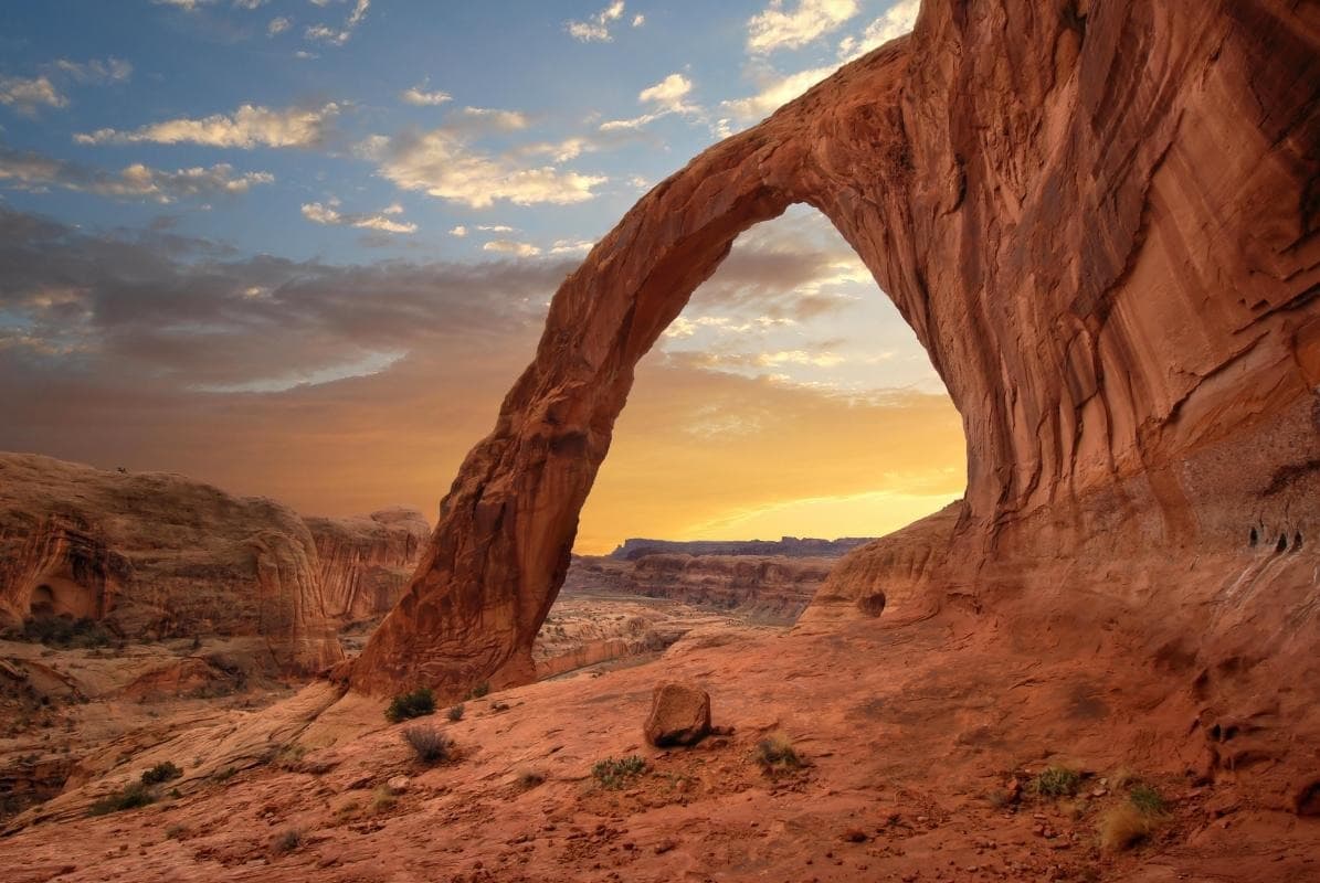
What the day feels like
The morning light moves like a slow hand across the sandstone, easing color into the crevices and warming the carved face of Corona Arch until it seems to inhale. You leave the Potash Road parking area with a thermos, sunscreen, and the expectation of a steady desert walk, but the route does something quieter: it lets you arrive. The trail threads through slickrock bowls and pinyon-studded draws before opening onto a wide ledge where Corona hangs over you like an old, patient door—an arc of rock that frames the sky.
Corona Arch is not a postcard tucked inside a park brochure; it is a moment you walk into. The classic out-and-back is roughly 3.0 miles round-trip with about 400 feet of elevation change. It is a moderate hike in the way most desert hikes are—short, technical in spots, and emotionally generous. There are a few short exposed scrambles and a fixed chain where a step down can be steep; nothing that requires ropes, but enough that you feel your balance return to you in a focused, immediate way.
Geology here reads like a layered biography. The arch stands in Entrada Sandstone, laid down in the Middle Jurassic when this landscape was a broad coastal dune field. Over 150 million years of wind and water sculpted thin fins and then removed the softer rock to leave the freestanding span you see today. Corona’s vaulted opening points to the erosive patience of time; weathered spalls at its base remind you that the desert is still at work, unmaking and remaking these forms even as you look.
This land has always had human stories layered on top. Long before Moab became a hub for off-roaders and climbers, Ute and other Indigenous peoples moved seasonally through this country; petroglyph panels along the nearby Potash Road are a compact record of those presences. Later came miners and potash works in the 20th century whose roads are now the same tracks visitors use to reach trailheads. Unlike the arches inside Arches National Park, Corona sits on Bureau of Land Management (BLM) land—close to civilization, but with a looser, wilder edge.
Those practicalities matter. The trailhead sits off Utah State Route 279—Potash Road—about 16 miles north of US-191 and a 20–25 minute drive from downtown Moab. Parking is free, but it fills quickly on sunny weekends and holidays. The route is well-marked early on, then walks across slickrock slabs where cairns and painted arrows keep you honest.
The immediate payoff is visual: the open curtain of sky framed by Corona, the way late-afternoon light pours through and gilds the alcove beneath. But the arch rewards more than snapshots. Its scale invites you to sit, unpack a sandwich, and let the currents of wind move through the space beneath the stone. In late summer evenings you can watch thermals catch dust motes; in winter, the crisp air makes the sandstone glow like fired clay. If you have the stomach for exposure, there’s a short scramble to the top of the arch from the west side that gives a vertigo-satisfying, horizon-wide view back toward the La Sal Mountains and the spine of the Colorado Plateau.
Practical edges: footwear matters. The slickrock can be smooth and unforgiving when worn soles meet steep slabs. Bring a minimum of 2 liters of water per person in summer, wear a sun hat, and start early to avoid the brittle heat or late-afternoon crowds. Cell reception is spotty—good for checking a map, poor for reliying on in an emergency—so tell someone your plan and carry a basic first-aid kit.
Conservation here is straightforward and immediate. Corona sits on BLM-managed land that welcomes visitors but relies on them to stay on routes, pack out trash, and refrain from chalking or bolting the natural stone. Climbing on many freestanding arches is discouraged because surface fungi and microbiotic soil crusts are easily damaged and take decades to recover. Treat this place as you would an ancient structure: admire its architecture, but do not alter it.
So who should come? Hikers with a baseline of fitness who are comfortable with short exposures and rock-scramble sections will find Corona Arch an ideal half-day objective. Families with older kids can make a morning of it; photographers and landscape painters will spend hours calibrating light. For a traveler based in Moab, it’s an easy, non-commercial antidote to the long scenic drives and adrenaline sports that also define the region.
If you’re planning a visit, pair the hike with an afternoon along Potash Road: look for petroglyph panels, the rusting remnants of old potash works, and the linear patterns carved by trucks and rivers. Time your visit for golden hour if you want dramatic photos, or arrive at first light if you prefer solitude. Either way, let the arch do what it does best: make you small, make you slow, and give you a concrete place to practice paying attention.
Corona Arch will not change your life in a single dramatic moment, but its scale and setting will refine your sense of perspective. It asks nothing but your boots, your curiosity, and a little respect. Walk up to it and stand beneath that vaulted rim—listen for the wind—the desert has a way of answering.
Length & logistics (quick): ~3.0 miles round-trip, ~400 ft elevation gain, allow 2–4 hours depending on stops. Trailhead: Potash Road (UT-279), roughly 20–25 minutes from downtown Moab. Fees: none (BLM land). Crowds: moderate; busiest mid-day and on weekends. Safety: carry water, sunscreen, and a map; cell service is unreliable.
Why go now: Corona Arch is both accessible and iconic—an easy-to-reach expression of the plateau’s slow handiwork, perfect for travelers who want a big, photogenic reward for a modest effort."
Trail wisdom
Small choices, better day.
Hydrate early and often
Carry at least 2 liters per person in summer and start before the heat builds; there is no reliable water on the trail.
Slickrock requires good traction
Wear sturdy hiking shoes with sticky soles—flip-flops and smooth-soled shoes are hazardous on the slabs and scrambles.
Use the chains and handholds with care
Short exposed sections have fixed chains; test holds before committing and move deliberately—these are fixed aids, not replacements for care.
Protect the rock
Do not bolt, chalk, or climb on fragile surfaces; stay on established paths to protect cryptobiotic soils.
Local knowledge
Read the place, not just the route.
Watch for native species including desert bighorn sheep, common ravens.
Keep an eye out for wildlife during the transition between areas and habitats. Respect distance guidelines.
The arch is on BLM land; visitors should stay on established routes, pack out trash, and avoid altering rock surfaces to preserve fragile cryptobiotic soils and sandstone patinas.
Follow the guide's instructions on size limits, ethical handling, and leave-no-trace practices.
Bowtie Arch — a smaller partner formation visible from the same trail system. Potash Road petroglyph panel and old potash works remnants along UT-279
Locally recommended viewpoints and quiet spots known best to local operators.
Corona Arch formed in Entrada Sandstone during the Jurassic; the area near Potash Road later hosted 20th-century potash mining operations that shaped early access roads.
Maritime roots and regional tradition shape the waterways and working coasts.
Seasonal guide
Four versions of the same landscape.
Spring
Best forwildflower contrasts · cool daytime hiking · photography
Challengesoccasional spring storms · mud in low areas
Spring offers comfortable temps and dramatic light, but watch for sudden weather and wet slickrock after rains.
Summer
Best forearly-morning solitude · extended daylight · stargazing after cool evenings
Challengeshigh heat, risk of dehydration · intense sun exposure
Summer days can be hot; hike at dawn or dusk, bring extra water, and expect to retreat from midday sun.
Fall
Best formild temps · clear skies · golden-hour photography
Challengesbusy weekends as temperatures idealize · cooler nights
Autumn is optimal for most hikers—comfortable conditions and clear visibility make it the busiest season.
Winter
Best fordramatic low-angle light · fewer crowds · snow-dusted sandstone scenes
Challengesicy patches on slickrock · cold winds
Winter can be beautiful and quiet but bring traction devices for icy slabs and layer for cold winds.
Pack with intention
What to bring.
Good to know
Common questions.
The round-trip is about 3.0 miles with roughly 400 feet of elevation change; allow 2–4 hours depending on stops and photography.
Plan the edges
The details that make the day easier.
Corona Arch is on Bureau of Land Management (BLM) land, not inside Arches National Park, and is accessible from Potash Road (UT-279) near Moab.
Moab mixes a rugged outdoor ethos with desert-friendly dining—think savory Navajo tacos, microbrews after a long hike, and local outfitters who can advise on permits and sustainability. Local guides emphasize Leave No Trace and respect for Indigenous histories tied to the land.
- Distance
- ~3.0 miles RT • Elevation gain: ~400 ft • Trailhead: Potash Road (UT-279) • Access: ~20–25 minutes from Moab • Fees: none (BLM) • Difficulty: Moderate.
Stay on designated trails to protect cryptobiotic soils, pack out waste, and avoid climbing or bolting on arches—these measures keep fragile desert ecosystems intact for future visitors.
Explore by topic
Follow the threads.
Keep exploring
Make the story part of the trip.
Set out from Bass Harbor for a private, customizable day on Blue Hill Bay — lighthouses, puffins, seals, and the chance to feel Acadia from the water. Small groups, local captains, unforgettable views.
In four hours you can move from shaded canyon ferns to wind-scoured coastal ridgelines, guided by someone who knows where the light—and the hidden views—live. This private half-day hike on the Monterey Peninsula or Big Sur is compact, curated, and perfect for travelers who want depth without a multiday commitment.
 Related story
Beneath a sky of shifting light, Skaftafell’s ice reads like a map of time. This three-hour guided glacier hike mixes technical instruction with geology and culture: compact, safe, and unforgettable.