
What the day feels like
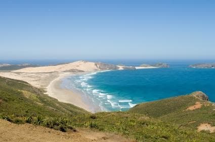
You come to Ninety Mile Beach for the horizon — a long, low line where sand meets sea and sky, interrupted only by the occasional silhouette of a wild horse or the white wedge of a dune. On a clear morning the water is a hard, reflective sheet; at low tide the beach becomes a transient highway, wide enough for a coach, and the sand takes on the texture of a weathered runway. Walk close to the surf and it dares you with an audible hiss, pulling pebbles and shells into neat, temporary patterns. Step away toward the dunes and the beach's manner changes — wind-carved ridges, pockets of spindly pingao grass, and the slow, indifferent presence of the Tasman Sea to the west.
Ninety Mile Beach (Te Oneroa-a-Tohe) is less a single destination than a spine along New Zealand's far northern peninsula, an 88-kilometre sweep of silica sand that runs north from Ahipara toward the remote tip near Cape Reinga. The beach is inseparable from the surrounding topography: to the east, broad pastoral flats and low kauri-dotted hills; to the west, the Tasman's long, rolling surf. At its northeastern end the land narrows into the Tapotupotu Bay and the Cape Reinga headland — where tradition says the spirits of departed Māori leap into the sea to return to Hawaiki.
Geology here is honest and fast. The sand is the product of millennia of coastal erosion and river-borne sediment; its fine, pale grains reflect the sunlight and give the beach the feeling of being endlessly luminous. The Te Paki Dunes, a short spin inland, are a different lesson: towering walls of silica sand formed by wind and storm, sculpted into slopes that can reach up toward a hundred metres. They are both playground and textbook — you can sandboard down a face or study the classic cross-bedded layering that tells a story of shifting winds.
Culture and history thread through every stop. For Ngāti Kahu and the other iwi of Te Tai Tokerau, this coast is living land. Cape Reinga's lighthouse and the nearby pohutukawa-studded lookout are more than scenic icons: they are wahi tapu, places of deep spiritual meaning. Local guides — whether on a coach from Paihia or a small-group tour combining flight and driving — regularly frame the landscape in that context, pointing out middens, old pathways, and stories that tie the coastline to ancestry and voyaging.
If you're short on time, a Cape Reinga scenic flight-and-drive tour is the most concentrated way to understand the region: the plane gives you the scale — the thin, bright ribbon of Ninety Mile Beach, the stunning contrast of the Pacific and Tasman currents where they meet — and the ground time lets you feel the sand underfoot at Tapotupotu or watch wild horses graze near the dunes. If you can spare more time, a Bay of Islands multi-day itinerary lets the beach sit within a larger frame of coastal bays, historic islands, and marine life.
On the practical side, Ninety Mile Beach is both accessible and territorial. Much of it is drivable at low tide, which means timing is everything: local tour operators and signage will remind you to check tide tables and weather, and if you plan to self-drive you need a sturdy vehicle and an experienced hand. The sand compacts well at low tide, but soft spots can trap the unwary. Walking the beach is straightforward — flat, long, and forgiving — but once you climb the Te Paki Dunes expect steep, loose sand that will test lungs and muscles in short order.
Best times to visit are the warmer months, when longer daylight and settled weather make coastal exploration pleasant; dawn and dusk are when the beach feels most theatrical, and when the light flatters every photograph. Bring sun protection, water (there are long stretches without services), and layers for the wind. Footwear is a choice: barefoot along the wet sand is liberating but having a pair of sandals or trail runners for the dunes and bracken is sensible. If you head north to Cape Reinga, allow time to linger at the lighthouse and to walk the short tracks to the headland viewpoints — the smell of salt and the sound of colliding seas create a clarity that sticks with you.
For travelers who want an active day, sandboarding on Te Paki's dunes is the classic move — quick to learn, instant payoff — and the landscape is uniquely photogenic. For a more contemplative visit, time your trip for low tide and walk for kilometres, watching the shoreline's geology reorganize itself after every wave. Guided tours bring context: drivers share Māori narratives and point out native plants, while pilots from scenic flights explain the large-scale tectonics that have created New Zealand's ragged coastline.
There is a responsibility that comes with visiting a place as exposed as Ninety Mile Beach. Stay off sensitive vegetation, avoid driving on dunes or through breeding bird habitats, and give wild horses a wide berth. Travel with the intention of leaving no trace and, when possible, support local operators who work with iwi and invest back into the communities that steward this coast.
On the sand, the landscape seems patient and unmoved by human footsteps. But those footsteps, if taken with care, allow you to engage with a coastline that is both raw and friendly — a place to test your balance on a board, to find silence at the water's edge, and to watch the sun fold itself into an ocean that has been shaping the land for epochs. Ninety Mile Beach makes even short visits feel like true travel: you arrive changed, if only because you walked along an edge and could see, for a while, the world laid out in a very simple, very honest line.
Trail wisdom
Small choices, better day.
Check tide tables before you go
Many parts of the beach are only reliably drivable or walkable at low tide; consult local tide charts and permit traffic windows.
Wear layered sun protection
Wind can be cool but the UV is strong; bring a sunhat, SPF 50, and sunglasses even on overcast days.
Bring 2–3 liters of water per person
Services are sparse along the beach; dehydration is easy under sun and sand, especially while climbing dunes.
Give wild horses space
These animals are semi-feral and may react unpredictably; observe from a distance and never feed them.
Local knowledge
Read the place, not just the route.
Watch for native species including New Zealand fur seals (occasionally seen on rocky outcrops), Feral/wild horses grazing along the dunes and shoreline.
Keep an eye out for wildlife during the transition between areas and habitats. Respect distance guidelines.
Ecosystems here are fragile; stay off dune vegetation, dispose of waste properly, and support operators that partner with local communities and conservation projects.
Follow the guide's instructions on size limits, ethical handling, and leave-no-trace practices.
Tapotupotu Bay — a sheltered cove with picnic spots and clear water for a quiet stop.. Te Rerenga Wairua track sections near Cape Reinga for short, interpretive walks and expansive views.
Locally recommended viewpoints and quiet spots known best to local operators.
The coast is part of the ancestral lands of several iwi; Cape Reinga is a traditional departure point for spirits in Māori cosmology.
Maritime roots and regional tradition shape the waterways and working coasts.
Seasonal guide
Four versions of the same landscape.
Spring
Best forwildflower displays · milder winds · fewer crowds
Challengesunsettled weather · cold mornings
Spring brings cool, often blustery days and early wildflower displays on the dunes; pack layers for variable conditions.
Summer
Best forswimming and paddling · sandboarding · long daylight hours
Challengesstrong sun · busy weekends
Summer is peak season for beach activities and scenic flights — expect warm temperatures and more visitors.
Fall
Best forphotography · calmer seas · surfing windows
Challengesshortening days · occasional storms
Autumn offers crisp light for photography and quieter access, but storms can roll in quickly from the Tasman.
Winter
Best forstorm-watching · lone beach walks · tidepool exploration
Challengescold wind · rough seas · limited services
Winter is dramatic and often wild; bring windproof layers and check weather warnings for safe travel.
Pack with intention
What to bring.
Good to know
Common questions.
Much of the beach is drivable at low tide and local operators do so, but driving the full length requires a suitable vehicle, local knowledge and strict attention to tide times and conditions.
Plan the edges
The details that make the day easier.
Despite its name, Ninety Mile Beach (Te Oneroa-a-Tohe) is roughly 88 kilometres (about 55 miles) long and is one of New Zealand’s most iconic coastal drives.
The Far North blends Māori cultural heritage with a laid-back surf-and-farm community. Stop in Kaitaia for seafood and kai moana, try local kūmara dishes, and seek out marae experiences or guided storytelling to better understand the coast’s significance.
- Access
- drive from Kaitaia
- Ahipara; Permits
- none for general visits but check local rules for vehicle access; Safety: tide and weather-aware travel only; Services: limited — fuel and food in Kaitaia; Time needed: half-day to full-day for beach + dunes, add time for Cape Reinga.
Stick to marked tracks, avoid driving on dunes, don’t feed wildlife, and choose operators who work with local iwi to reduce footprint and support community stewardship.
Explore by topic
Follow the threads.
Keep exploring
Make the story part of the trip.
Set out from Bass Harbor for a private, customizable day on Blue Hill Bay — lighthouses, puffins, seals, and the chance to feel Acadia from the water. Small groups, local captains, unforgettable views.
In four hours you can move from shaded canyon ferns to wind-scoured coastal ridgelines, guided by someone who knows where the light—and the hidden views—live. This private half-day hike on the Monterey Peninsula or Big Sur is compact, curated, and perfect for travelers who want depth without a multiday commitment.
 Related story
Beneath a sky of shifting light, Skaftafell’s ice reads like a map of time. This three-hour guided glacier hike mixes technical instruction with geology and culture: compact, safe, and unforgettable.