Whitewater River Directory
Discover the best whitewater kayaking and rafting destinations
Showing 12 whitewater routes
Alamo Dam
Bill Williams River: Alamo Dam to US-95 – A Remote Desert Whitewater Journey
The Bill Williams River offers a rare desert paddling experience defined by slow currents and gentle rapids, flowing through remote, sun-baked terrain. This stretch runs from Alamo Dam westward toward the Colorado River, passing through wild lands lined with cottonwoods and willows. Its flow depends heavily on dam releases from Alamo Lake, primarily fed by the Santa Maria River with seasonal monsoon surges. This river blends contemplative paddling with occasional modest whitewater that ramps up after significant water releases. Isolation, ecological richness, and a steady, measured pace define the journey here, inviting paddlers to engage with an Arizona river both wild and reserved.
Last Chance Bridge
North Fork Middle Fork American River: Last Chance Bridge to Middle Fork Confluence
The North Fork Middle Fork American River run from Last Chance Bridge to the Middle Fork confluence is a fiercely demanding paddle carved through steep gorges with formidable Class V rapids. Early adventurers faced snow-covered trails and hand-carried gear into this untamed corridor, where drops push the limits of technical paddling. Highlights include the vertical cliffs framing Devil's Gate and the sequence of lead-offs that test control and commitment. The river flows cold and clear, fed by snowmelt with gradient that accelerates the current swiftly through constricted rock bands. Access to the start involves forest road travel and then hiking with gear, underscoring the wild nature of the section. The take-out at Mosquito Ridge Road or downstream rafting staging areas serves as convenient collection points after a multi-hour journey that exposes paddlers to the rugged core of the American River’s upper basin.
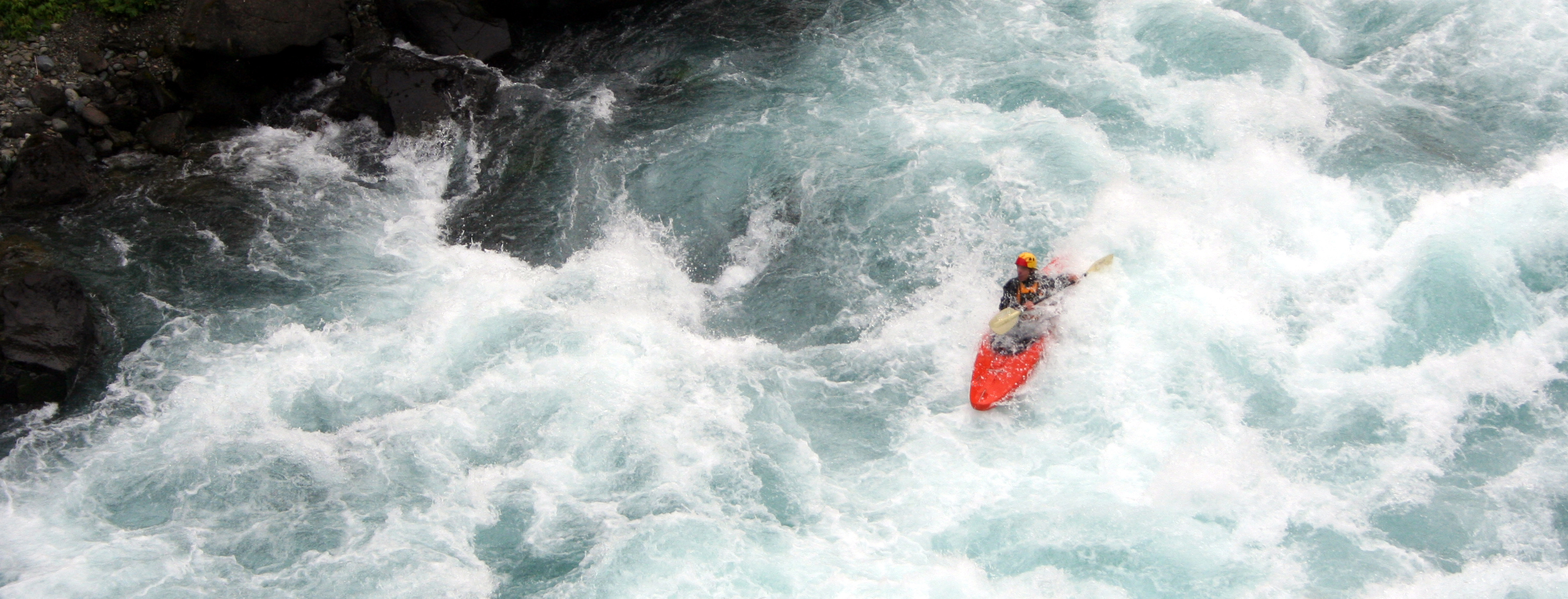
Euchre Bar Trailhead
North Fork American River - Giant Gap (Euchre Bar to Mineral Bar)
Giant Gap offers a blend of thrilling whitewater and vast canyon wilderness across 14.4 miles on the North Fork American River. Starting with a physically demanding trail descent to the river, paddlers immediately face Class III rapids that lead into steep, vertical canyon walls. This stretch packs a series of increasingly challenging rapids, from the shallow, congested Grater to explosive Class V hazards including Nutcracker, Locomotive Falls, and Dominator. Just as the intensity fades, the run finishes with Pinball, a complex rapid that demands clean lines and keen focus. Surrounding cliffs rise dramatically, framing the clear, roaring water with deep forest and raw rock. The run encapsulates the rush of moving water and the solitude of a wild canyon, making it a must for experienced boaters ready for serious adventure. Planning for trail hiking, scouting difficult rapids, and managing flow levels will ensure a safer and more rewarding experience.
Confluence of Middle Fork and North Fork American River
North Fork American River: From Confluence to Folsom Lake
Stretching from the meeting point of the Middle and North Forks to the edge of Folsom Lake, this section of the North Fork American River navigates a terrain molded by water and human intervention alike. Paddle through evolving waves and hydraulics shaped by the Auburn Pumping Station and venture down quiet canyons alongside the historic Auburn Dam site. Accessibility varies by take-out and season, but the route offers a rewarding whitewater experience with manageable Class II(III) rapids, well suited for paddlers wanting a steady challenge blended with scenic diversity.
Colfax-Foresthill Road
North Fork American River: Yankee Jims Bridge to Lake Clementine
This section of the North Fork American River invites paddlers into an active current that shifts between rhythmic Class II and heartening Class III rapids. River left and right granite banks rise sharply, confining the flow through multi-riffle runs and gentle eddy pools. The river’s pulse quickens below Yankee Jims Road, with flows carving braided rapids that test boat control without feeling overwhelming. The run suits paddlers stepping up beyond beginner routes, rewarding sound skill with a consistent challenge and natural beauty. Wildlife and forested slopes hug the river corridor, while the broad range of campsite permits ensures respectful overnight stays that conserve the river’s integrity. The Ponderosa Bridge takeout provides a shorter, accessible exit, while the longer run to Upper Lake Clementine gives more distance and complexity for those prepared to embrace it fully.
Mineral Bar Put-In
North Fork American River: Chamberlain Falls Section
Known for its accessible proximity to Sacramento and a concentrated dose of Class IV whitewater, the Chamberlain Falls section invites paddlers to navigate a tight sequence of rapids through a forest-lined canyon. The river's pulse quickens here, ranging from manageable flows to powerful surges demanding skill and respect. Each rapid presents a unique challenge—from the sizable hydraulic of Chamberlain Falls to the twisting rocky corridors of Grand Slalom—where strategic scouting and clear communication become essential. While short, this run offers an adrenaline boost that balances raw excitement with natural beauty framed by a protected California recreation area.
Oxbow Bend (just below Oxbow Powerhouse penstock)
Middle Fork American River: Oxbow Bend to Drivers Flat Road Adventure
This river run pushes paddlers through an exhilarating sequence of rapids carved into the Sierra foothills, combining deep forest canyons with historical mining terrain. From icy put-in waters beneath the powerhouse to the intense chute and tunnel runs near the start, every mile presents opportunities to test your skills and absorb natural beauty. Annual events influence river flow timing, and camping requires permits, but these logistics support a well-managed and rewarding river experience. Expect cold water, variable flows, and technical obstacles requiring scouting and caution, particularly at Tunnel Chute and Ruck-A-Chucky Falls where life-and-death scenarios underscore the seriousness of this run.
Interbay Dam (End of the World Powerhouse)
End of the World Run: Middle Fork American River Adventure
The End of the World Run on the Middle Fork American River is a challenging high-gradient stretch that combines technical Class IV and V rapids with long, intense boulder gardens and high-flow bedrock chutes. Starting at Interbay Dam, the route tests paddlers with demanding rapids in the opening three miles before easing somewhat mid-run, allowing moments for river-reading and recovery. The steep finale demands respect, with several hard drops that can be portaged if water levels are low or to reduce risk. Reliable flow information is critical here, with runs best staged between 300 and 600 cfs. Portage routes are available but require care as poison oak grows near the roads. This run is a test of endurance, skill, and river savvy, demanding careful preparation and sharp paddling focus to navigate successfully through one of Northern California’s rawest whitewater corridors.
Ruck-A-Chucky Campground
Ruck-A-Chucky Campground to Mammoth Bar: A Classic Class II Run on the Middle Fork American River
The Ruck-A-Chucky to Mammoth Bar section of the Middle Fork American River runs through a deep, secluded canyon, accessible only in summer months due to State Park regulations and reservoir release schedules. The river offers steady Class II rapids, mostly open riverbed, and pockets perfect for play and skill-building. A standout rapid near mile 3.5 demands attention but provides an easy channel for beginners. A small wave-hole near mile 6 offers fun play opportunities before the run finishes at Mammoth Bar, directly upstream of the challenging Murderer’s Bar Rapid. Paddlers looking for scenic isolation and manageable rapids will find this a dependable choice, provided shuttle logistics and access guidelines are observed.
Sailor Bar Launch Ramp
Lower American River from Nimbus Dam to Howe Avenue: A Year-Round Whitewater Journey
The Lower American River offers a steady, year-round watercourse weaving through Sacramento’s American River Parkway. Along this 14-mile stretch, paddlers encounter gentle riffles that build to the pulse of the San Juan Rapids, notable for their accessible yet exciting whitewater. The river’s gradient and flow create an inviting environment suitable for casual floats and active playboating alike. Legal access points such as Sailor Bar and Sunrise Avenue provide reliable entry and egress, adjacent to bike paths and parking areas. With ongoing environmental efforts aimed at removing barriers near Nimbus Dam, this section hints at a future where enhanced wave features will broaden opportunities for river recreation. For now, this reach balances community gatherings, competitive races, and daily river outings under a canopy of riparian trees and open skies.
Rossmoor Bar
San Juan Hole: The American River’s Playful Whitewater Feature
The San Juan Hole is a brief but intense whitewater feature along the American River characterized by a sharply descending gradient and a playful hydraulic that adapts dynamically to varying flows. This run serves as a concentrated playground for paddlers seeking technical maneuvers amid the urban-close current. With flows between 1,400 and 3,100 cfs, the spot morphs from a shallow, tricky hole to a high-velocity foam wave that encourages spins and cartwheels, demanding precision and confidence.
Floriston Exit 199
Truckee River Whitewater Run from Floriston to Verdi, Nevada
From the moment you lower your paddle into the Truckee River near Floriston, the current engages you in a dialogue of steady motion and sudden bursts. Its waters press onward past gravel banks and ancient diversion structures whispering stories of past industry. The pace picks up through a series of manageable Class II rapids, inviting a warm-up at the surface of swift currents and clean, cold splashes. As you approach Deadman's Curve, the river takes on a new voice—insistent, demanding respect. The corner wraps tightly around the riverbanks, pushing water against rock walls that challenge your line and timing. This rapid can escalate to Class IV at higher flows, with hydraulics forming unexpected pockets that push back if your craft hesitates. Navigating this stretch becomes a test of focus and agility, a reminder that the river lives and breathes alongside you. Beyond Deadman's, the presence of the historic diversion dams calls for caution. Running them is a gamble that depends entirely on flow, and scouting or portaging remains the prudent choice for most paddlers. This rhythm of rapid runs punctuated by careful carries shapes the character of the trek downriver. The run eases toward Crystal Creek Park, where river right banks open to a welcoming take-out beneath the highway bridge. Here, the river slows to a steady pace, sharing glimpses of broad floodplains where birds and trees converse with ripples across the surface. Completing this passage leaves paddlers with a tangible sense of accomplishment, having danced with a river both disciplined and wild.