Paddle the Quabbin: Quiet Waters and Forgotten Villages Beneath
Paddle through the Quabbin Reservoir’s vast, tranquil waters to uncover a hidden world beneath—forgotten villages swallowed by time and memories. This adventure combines peaceful paddling with the thrill of exploring a historically rich and ecologically protected area perfect for novice and seasoned paddlers alike.
Start Early for Calm Waters
Wind tends to pick up in the afternoon, making paddling more challenging. Launch in the early morning hours to enjoy smoother water and better wildlife sightings.
Use Water-Resistant Gear
The Quabbin’s open water can spray unexpectedly. Equip yourself with waterproof bags and quick-dry clothing to stay comfortable throughout your trip.
Pack Ample Water and Snacks
There are no facilities on the water, and the quiet can mask your thirst or hunger. Stay hydrated and energized to maintain focus and stamina.
Respect the Wildlife and Watershed Rules
No motorized boats or fishing are allowed to keep the reservoir pristine. Maintain quiet to avoid disturbing eagles, herons, and other wildlife.
Paddle the Quabbin: Quiet Waters and Forgotten Villages Beneath
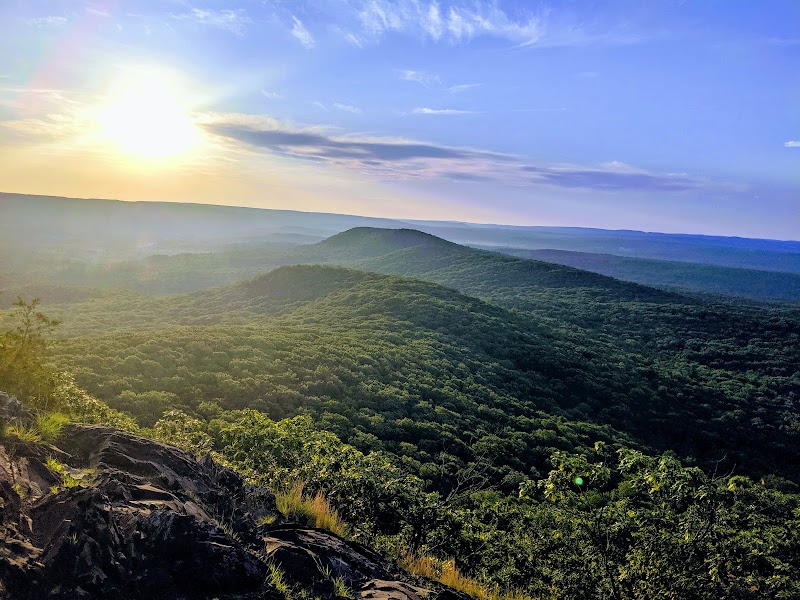
Stretching over 38 square miles, the Quabbin Reservoir offers one of Massachusetts’ most compelling paddle adventures—a place where placid waters guard the stories of submerged villages and whisper through thick forest canopies. Launch your kayak or canoe into these quiet waters, and you enter an arena where nature and history dare you to explore beneath the surface and beyond the shoreline.
The reservoir’s calm expanse is framed by steep, forested slopes and dotted with islands that resist time’s erosion. Paddling here means engaging with a powerful stillness—a body of water fiercely itself—that both invites and demands respect. The current is gentle, but wind gusts push you to read the lake constantly, adjusting your course as you discover inlets and coves once home to communities now lost beneath the water.
Your journey can span anywhere from 3 to 8 miles depending on your route. Trails of water lead you past submerged foundations and forgotten roads, relics of the four towns swallowed during the reservoir’s creation in the 1930s. These silent reminders add a layer of tension and curiosity to the paddle—what happened here, and how nature has reclaimed this space?
To plan your trip, prepare for changing weather and water conditions. Lightweight, waterproof gear keeps you dry when the wind carries a chill. Footwear should be sturdy yet agile enough for launching across rocky shores. Hydration is vital; the reservoirside shade offers relief but can lull paddlers into dehydration if ignored. Early mornings or late afternoons offer the clearest waters and softest light for both navigation and photography.
Access points such as the Swift River Access and Quabbin Boat Launch provide solid entry spots, with parking and restrooms nearby. Be ready for limited cell service and remember this is a protected watershed, so no motorized boats or fishing are allowed, underscoring the reservoir’s role as a vital water source. Respect for this ecosystem means behaving as a guest—pack out all waste, avoid disruptive noise, and observe wildlife quietly.
The Quabbin’s forests are home to bald eagles and herons, their keen eyes watching from branches as you pass beneath. In spring, migrating songbirds fill the shoreline with sound; in fall, the steep woods blaze with color, reflecting vibrantly off the water’s surface. Photography is best at dawn or dusk, when mist drifts over the water and the mood becomes almost otherworldly.
Paddling the Quabbin is more than a mere excursion; it’s a dialogue with a landscape that challenges your skills and reveals history’s weight beneath serene waters. It demands preparedness, patience, and attentiveness. For those who answer its call, quiet waters offer discovery, and the forgotten villages lend their stories, waiting to be read in the ripples and the wind.
Nearby Trips
All Adventures
Boat Charters
Water Activities
Adventures near Ware, Massachusetts
Discover the unique and memorable adventures that make Ware, Massachusetts special.
Frequently Asked Questions
Are motorized boats allowed on the Quabbin Reservoir?
No. To protect the watershed that supplies Boston’s drinking water, motorized boats and fishing are prohibited. Non-motorized boats like kayaks and canoes are permitted at designated access points.
Where can I launch my kayak or canoe at Quabbin?
Common access points include the Swift River Access and Quabbin Boat Launch near the town of Ware. These locations provide parking and basic facilities but expect minimal services.
Is it safe to paddle alone on the Quabbin Reservoir?
While fishing and swimming are prohibited, paddling alone is possible with adequate experience and preparation. The reservoir’s size and limited cell coverage mean you should inform someone of your plans and carry safety gear.
What wildlife might I see while paddling on the Quabbin?
Watch for bald eagles perched high in the trees, great blue herons fishing the shallows, and white-tailed deer in the surrounding forests. Birdsong fills the edges especially during migration seasons.
Are there guided tours or rentals available at the reservoir?
No official guided tours or rentals operate directly on the Quabbin Reservoir due to its protected status. Local paddling clubs occasionally organize trips. Visitors should bring their own equipment.
What should I know about the history submerged beneath the water?
The reservoir covers four former towns—Dana, Enfield, Greenwich, and Prescott—displaced and flooded in the late 1930s to create this critical water supply. Foundations and roadbeds remain underwater, creating an eerie, hidden past beneath the surface.
Recommended Gear
Lightweight kayak or canoe
Easier to maneuver in the reservoir’s calm but occasionally gusty conditions, a sturdy craft is vital to navigate inlets and variable winds.
PFD (Personal Flotation Device)
Safety first: water currents may be mild, but a PFD is essential for any paddling activity on the Quabbin.
Waterproof dry bag
Protect your essentials—phone, food, clothing—from unexpected splashes or capsizing.
Layered quick-dry clothing
The weather can shift rapidly; moisture-wicking fabrics help regulate body temperature while keeping you comfortable.
Local Insights
Hidden Gems
- "The small islands scattered across the reservoir offer private stops and quiet wildlife observation points."
- "Look for remnants of old roadbeds visible at low water levels, especially near the northern sections."
- "The Quabbin Watch Tower ruins, accessible via a short paddle and hike, provide panoramic views rarely visited."
Wildlife
- "Bald eagles have returned here in recent years, and autumn is a great time to spot their soaring forms."
- "Black bears roam the surrounding forests but rarely come close to the shoreline."
- "Migrating warblers and woodpeckers announce spring’s arrival with vibrant calls."
History
"The reservoir was created by flooding four Massachusetts towns in the 1930s to fulfill Boston’s growing water demands. This massive project displaced thousands, and their communities now lie beneath the water, preserved in silence."