Traversing Liechtenstein: The Ultimate Guide to Hiking the Nation’s Signature Trail
The Liechtenstein Trail offers a full circuit around one of Europe’s smallest countries, delivering a compact yet powerful hiking experience filled with alpine forests, sweeping ridges, and historic villages. This guide equips you with the essentials to plan your journey, combining vivid trail descriptions with practical tips for navigating the terrain.
Footwear Matters
Wear sturdy hiking boots with ankle support and a good grip to handle mixed terrain ranging from gravel to rocky sections safely.
Hydration Planning
Carry at least 2 liters of water; natural water sources are limited and often from fast-flowing mountain streams that may require treatment.
Pace Yourself
The trail covers around 75 km with considerable elevation; plan to hike 3–5 days depending on your speed and stamina to avoid fatigue.
Weather Awareness
Mountain weather shifts quickly—check forecasts daily and pack layers, including waterproof and windproof gear to stay comfortable.
Traversing Liechtenstein: The Ultimate Guide to Hiking the Nation’s Signature Trail
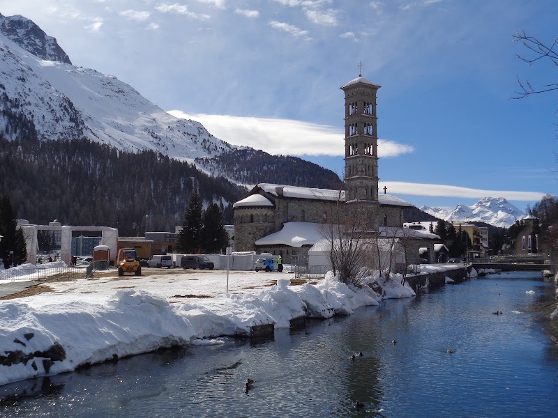
Hiking the Liechtenstein Trail means engaging with a landscape that won’t simply yield beneath your boots; it demands respect. Spanning roughly 75 kilometers and wrapping entirely around the principality, this trail locks you into a loop through forests that murmur with ancient pines, alpine meadows where wildflowers dare to sway in the breeze, and ridges that reveal the Alpine range in full force. Begin your journey in Vaduz, the capital, where the Rhine River carves a boundary that dares you to explore beyond.
Expect elevation gains totaling around 2,300 meters, interspersed with steady ascents and descents that keep momentum and heart rate in balance. Terrain varies: from gravel forest paths and grassy knolls to rocky outcrops that demand sure-footedness, making footwear a top priority. The trail’s flow matches the land’s rhythm—sometimes gentle and inviting, other times fiercely steep and rugged, a reminder this hike is an active dialogue with nature.
Water sources appear occasionally, but the river runs fast and cold at valley bottoms, pushing you to plan hydration carefully. Midpoints in villages like Triesenberg offer practical rest stops and a chance to sample local fare, adding a cultural layer to the natural encounter.
Timing your hike requires mindfulness. Spring and early summer bring a lush green-dark forest canopy and blooming edelweiss, while autumn turns the hills golden and crisp, though sudden weather shifts can challenge the unprepared. Winter closes parts of the route with snow, which transforms the trail into a distinct adventure for seasoned hikers equipped with winter gear.
Beyond logistics, the trail connects you with local eyes: the way birds follow thermal currents overhead, how mountain streams seem to chant ancient rhythms, and the villages that rise like quiet witnesses against the jagged skyline. Photography opportunities abound—golden hour casts sharp shadows on castle ruins or dips the Rhine valley into mystic hues.
For those considering this adventure, preparation is key. Choose sturdy boots with good ankle support. Pack layers to accommodate rapid temperature changes. Carry water and nutrition to maintain energy over long stretches when nature dares you to push forward. And above all, step lightly and move deliberately—this trail doesn’t just reward physical effort; it respects those who approach it with care and awareness.
In sum, hiking the Liechtenstein Trail is an achievable yet immersive trek that offers a full sweep of the country’s rugged beauty—a practical journey paired with profound natural engagement.
Nearby Trips
All Adventures
Boat Charters
Water Activities
Adventures near Vaduz
Discover the unique and memorable adventures that make Vaduz special.
Frequently Asked Questions
How long does it take to hike the entire Liechtenstein Trail?
The full loop covers about 75 kilometers, typically taking 3 to 5 days depending on your pace, fitness, and how often you rest or explore local villages.
Is the trail well-marked and easy to follow?
Yes, the Liechtenstein Trail is signposted with red-white-red markers common in the region, but hikers should still carry a map or GPS as some forest sections can be confusing.
What level of fitness is required?
A moderate level of fitness is recommended because of the total elevation gain (~2,300 meters) and daily distances that can exceed 15 kilometers.
Are there places to resupply or rest along the trail?
Yes, several villages including Vaduz, Triesen, and Malbun offer shops, restaurants, and accommodations where you can rest and replenish supplies.
When is the best time of year to hike the trail?
Late spring through early autumn (May to October) is ideal when the weather is stable and trails are clear of snow.
Are dogs allowed on the Liechtenstein Trail?
Dogs are permitted but should be kept on a leash especially near livestock and in village areas; be mindful of local wildlife and other hikers.
Recommended Gear
Sturdy Hiking Boots
Necessary for navigating mixed terrain and protecting ankles on uneven paths.
Layered Clothing
Allows adaptation to changing mountain conditions, including sun, cold, and rain.
Hydration System
Carrying sufficient water and a means to treat natural sources is critical for safety and endurance.
Compact Map and GPS
Ensures accurate navigation through forested and less-marked sections.
Local Insights
Hidden Gems
- "Ruggeller Riet Nature Reserve, a peaceful wetland with unique flora"
- "Old Weria Castle ruins offering panoramic views beyond the main tourist sites"
- "Quiet forest glades near Triesenberg where local moonwort fern grows"
Wildlife
- "Alpine marmots whistle warnings from high meadows"
- "Golden eagles circle thermals over mountain ridges"
- "Red deer are common in forested valleys, most active at dawn and dusk"
History
"The trail touches areas shaped by centuries of alpine farming and trade, including historic passes used since medieval times and castles guarding strategic viewpoints."