The Black Range Traverse: Remote Peaks and Forgotten Trails in New Mexico
The Black Range Traverse presents a rugged New Mexico adventure through isolated peaks and forgotten trails. For hikers seeking remote beauty paired with practical challenges, this route reveals itself through forests, rocky ridges, and wide vistas, demanding preparation and rewarding persistence.
Hydrate Wisely and Often
Water sources are unreliable and seasonal. Carry at least 3 liters and bring a solid filtration system to treat water from streams you encounter.
Pack Layered Clothing
Temperatures vary greatly with elevation and time of day. Dress in moisture-wicking layers and carry rain gear to stay dry during sudden storms.
Use Reliable Navigation Tools
Marked trails are sparse. Bring a detailed topographic map, compass, and GPS device to avoid disorientation among faint routes and forested ridges.
Start Early to Avoid Afternoon Storms
Summer afternoons often bring thunderstorms; getting on the trail at sunrise helps you cover distance during stable morning weather.
The Black Range Traverse: Remote Peaks and Forgotten Trails in New Mexico
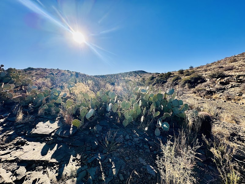
Stretching across southwestern New Mexico, the Black Range Traverse offers an unvarnished adventure through some of the state’s most isolated and rugged backcountry. This trail system spans roughly 50 miles, linking old mining roads, faint animal paths, and seldom-used forest routes that thread through a wilderness that feels nearly untouched. Elevation climbs to over 10,000 feet at peaks like McKnight and Emory, demanding stamina and steady footing as you pass through dense ponderosa forests, open meadows, and rocky ridgelines.
The traverse isn’t about grand conveniences—reliable navigation and solid hiking boots are non-negotiable here. Water is scarce, and streams, when found, test your filtration gear. But the rewards are real: expansive views where the Sangre de Cristo and Gila wildernesses reach toward the horizon, whispering winds through the aspens and towering firs that challenge your pace.
Prepare for shifting conditions. Morning fog can veil the path, while afternoon thunderstorms might push you to find quick shelter. Trails can be faint, demanding confidence with your map and compass or GPS. Wildlife, including mule deer and occasional black bears, live quietly in this space that’s fiercely itself, inviting respect rather than intrusion.
Start in the small town of Kingston or around the Mimbres Mountains, pacing yourself over days to savor the solitude and wide-open skies. Camp spots are sparse and basic, so plan ahead for backcountry permits and pack out all waste. This traverse isn’t just a hike; it’s a conversation with a wild land that dares you to keep moving forward and to listen to its quiet, persistent voice.
Nearby Trips
All Adventures
Boat Charters
Water Activities
Adventures near Truth or Consequences, New Mexico
Discover the unique and memorable adventures that make Truth or Consequences, New Mexico special.
Frequently Asked Questions
Is the Black Range Traverse suitable for day hikes?
The full traverse spans about 50 miles, typically tackled over multiple days. However, shorter segments can be done as day hikes, especially near trailheads close to Kingston or Truth or Consequences.
Do I need permits to hike the Black Range Traverse?
While no specific permit is required for hiking, camping permits from the Gila National Forest might be necessary for overnight stays. It's advisable to check with forest rangers ahead of your trip.
What wildlife might I encounter on this trail?
Expect to see mule deer, elk, and possibly black bears. Raptors like red-tailed hawks often soar overhead. Encountering these animals requires maintaining respectful distance and securing food properly.
How difficult is the terrain along the traverse?
The terrain ranges from gentle forest paths to steep, rocky ridgelines. Some sections have loose scree and exposed routes, so proper footwear and surefootedness are important.
Are there reliable water sources along the route?
Water is scarce and seasonal. There are intermittent streams, but hikers must carry adequate water supplies and purification gear to stay safe.
What is the best time of day to hike for safety and enjoyment?
Early mornings offer the most stable weather and cooler temperatures. Afternoon thunderstorms are common especially in summer, so plan to reach shelter or camp before storms develop.
Recommended Gear
Backcountry GPS Device
Critical for navigating the faint and unmarked trails throughout the traverse.
Water Filtration System
Necessary for treating water collected from streams and springs during the hike.
Sturdy Hiking Boots
Supports your ankles and provides traction on rocky, uneven terrain.
Insulated Jacket
Keeps you warm during chilly nights and sudden cold snaps at higher elevations.
Local Insights
Hidden Gems
- "The viewpoint atop McKnight Peak, offering panoramic vistas with fewer visitors."
- "A series of ancient mining ruins southwest of the main trails, hinting at the region’s past life."
Wildlife
- "Mountain lions inhabit the area but are rarely seen; always hike aware and noisy."
- "Migratory birds like the green-tailed towhee pass through the forested sections in spring."
History
"The Black Range was once a hotspot for silver and gold mining in the late 19th century, remnants of which remain scattered along less traveled paths, bearing silent witness to a bygone era."