Uwharrie Trail Thru-Hike: North Carolina’s Untamed Forest Adventure
Discover the Uwharrie Trail, a roughly 40-mile thru-hike weaving through North Carolina’s dense forestlands near Troy. This practical guide captures the trail’s rugged terrain and natural allure while equipping you with essential tips for a successful and invigorating adventure.
Hydrate Frequently and Filter Water
Water sources are available but can be sparse in dry months. Carry a lightweight water filter to refill safely from streams.
Wear Trail-Ready Boots
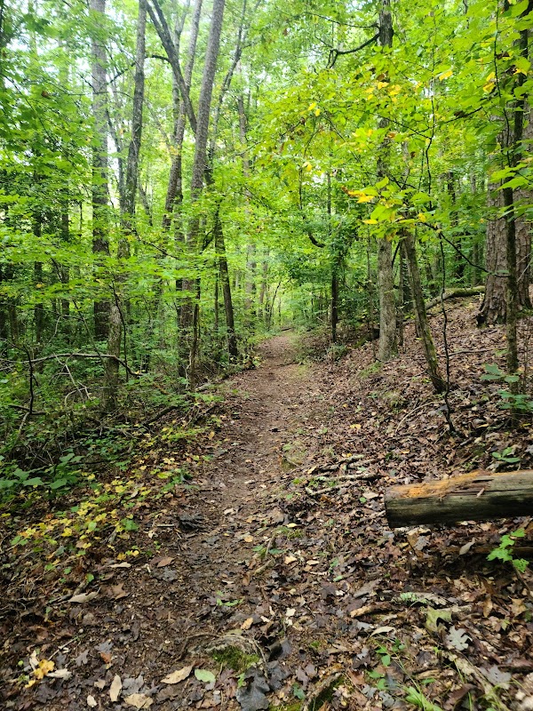
Expect uneven terrain with rocks and roots; sturdy boots with strong grip and ankle support reduce injury risk.
Plan for Limited Cell Service
Cell coverage is unreliable. Bring physical maps and a compass, and ensure someone knows your itinerary.
Start Early for Cooler Hiking Conditions
Temperatures can rise quickly, especially in summer. Early starts help avoid midday heat and enhance wildlife sightings.
Uwharrie Trail Thru-Hike: North Carolina’s Untamed Forest Adventure
Stretching nearly 40 miles through the Uwharrie National Forest near Troy, North Carolina, the Uwharrie Trail challenges hikers with an unvarnished wilderness experience steeped in rugged beauty and historical echoes. This thru-hike is a straightforward journey—not tailored for easy strolls, but for those ready to engage with terrain that rises and dips, twists through dense pine and hardwood stands, and offers quiet moments alongside streams that seem to dare you onward.
Starting at the trailhead near Asheboro, the path pushes across rocky ridges and soft forest floors, gaining roughly 2,000 feet in cumulative elevation. The landscape doesn’t flaunt high summits, but its hills are fiercely well-defined, each climb a tangible effort rewarded by steady air and patches of sunlight caught between leaves. The earth beneath is a mix of sandy soil and granite outcrops, requiring solid boots with good traction. Expect stretches of exposed roots and loose stones, alongside moments where the forest canopy opens to reveal wide views, especially near Caraway Mountain and Morrow Mountain outlooks.
Water sources run sporadically but consistently enough to refill filters, particularly after seasonal rains. The deep green of ferns brushing the trail contrasts sharply against the shifting patterns of sunlight—a natural rhythm that pulses underfoot. Along the way, you’ll encounter remnants of old mining sites and faint traces of Native American history, quietly marking the trail’s cultural layer.
Plan your hike to avoid the sweltering midsummer humidity, with spring and fall offering cooler temperatures and fewer insects. Carrying sufficient hydration is critical; the terrain tests your stamina with recurring elevation shifts and load-bearing miles. Footwear should emphasize stability and support, given the variability of the path beneath. Early mornings and late afternoons bring both the best light for photography and cooler conditions to pace comfortably.
Though the trail invites resilience, it respects those prepared. Weather can shift swiftly, from clear skies to sudden thunderstorms, demanding readiness with layers and waterproof gear. The remote stretches mean cell coverage is spotty—map reading and compass skills remain key tools. Camping is permitted at designated sites along the trail, allowing hikers to break the hike into manageable segments.
In all, the Uwharrie Trail thru-hike offers an active engagement with a forest that carries its own voice—steady, challenging, fiercely itself—and demands a response from those who walk it. For hikers ready to meet the land on its terms, it provides an honest, practical, and rewarding outdoor journey.
Nearby Trips
All Adventures
Boat Charters
Water Activities
Adventures near Troy, North Carolina
Discover the unique and memorable adventures that make Troy, North Carolina special.
Frequently Asked Questions
Is the Uwharrie Trail suitable for beginner hikers?
While the trail is not technically difficult, its length and elevation changes require moderate physical fitness. Beginners should prepare with shorter hikes and ensure they have adequate gear and navigation skills.
Where are the best spots to camp along the trail?
Designated campsites at Morrow Mountain and Drowning Creek offer clearings with water access and basic amenities. Planning stops here breaks the hike into manageable sections.
Are there any dangerous animals on the trail?
Wildlife includes typical forest animals like deer, snakes, and occasional black bears. Bears generally avoid humans, but always store food securely and remain alert.
How reliable is cell phone coverage on the trail?
Coverage is spotty at best, especially in deeper forest and ridge areas. Do not rely on phones for navigation—physical maps and a compass are necessary.
What historical features can hikers see on the Uwharrie Trail?
Hikers encounter remnants of 19th-century gold mining operations and traces of Native American activity. Interpretive signage along parts of the trail highlights this heritage.
Is the trail maintained year-round?
Trail maintenance occurs mainly in spring and fall but may be limited. Check with the Uwharrie National Forest office before your hike for trail conditions and closures.
Recommended Gear
Trail-running or Hiking Boots
Provides grip and ankle support over rocky and uneven surfaces common on the trail.
Lightweight Water Filter
Essential for safe hydration from natural water sources scattered along the route.
Layered Clothing System
Allows temperature regulation as the weather transitions from warm days to cool nights.
Map and Compass
Vital backup navigation tools due to patchy cell service and unmarked side trails.
Local Insights
Hidden Gems
- "The quiet overlook near Big Brush Creek offers limited crowds and expansive forest views."
- "A rarely visited loop trail near the Horse Pasture Trail junction displays seasonal wildflowers and quiet ponds."
Wildlife
- "White-tailed deer often appear near dawn and dusk."
- "Eastern box turtles and a variety of songbirds provide frequent sightings for attentive hikers."
History
"The area served as a gold mining hotspot in the early 1800s; remnants of mining shafts and equipment are tucked away, visible with some exploration. Native American tribes once inhabited this region, with archaeological findings pointing to their presence along creeks."