Beachside Backpacking: Exploring the Superior Hiking Trail’s Lake Superior Shoreline
Discover the raw beauty of Lake Superior’s shoreline on the Superior Hiking Trail’s beachside section. This 15-mile stretch blends forest and rocky beaches, offering hikers a practical yet invigorating backpacking adventure with lakeside views and demanding terrain.
Pack water and a filtration system
While there are streams along the trail, carry at least 2 liters of water and a filter to stay hydrated since lake water isn’t safe to drink untreated.
Wear sturdy, supportive footwear
The mix of rocky bluffs and sandy shore requires boots or trail shoes with solid traction and ankle support to prevent slips and injuries.
Watch the weather closely
Lake Superior’s weather can shift quickly; check forecasts and be prepared for sudden wind, rain, or temperature drops especially outside summer months.
Plan for moderate elevation changes
Expect frequent but manageable climbs and descents, so pace yourself and allow extra time to navigate rocky or root-filled sections carefully.
Beachside Backpacking: Exploring the Superior Hiking Trail’s Lake Superior Shoreline
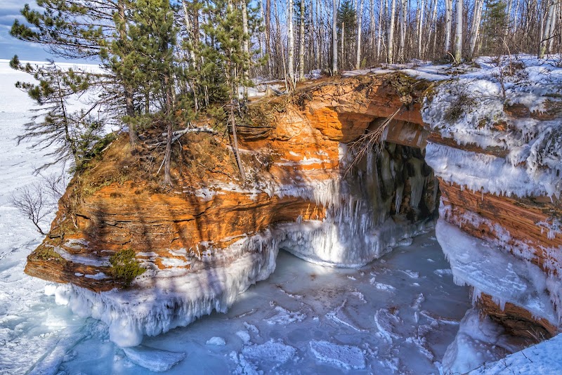
The Superior Hiking Trail (SHT) offers one of the most rugged and rewarding experiences along the north shore of Lake Superior. Focusing on the beachside section near the lake, this stretch challenges backpackers with a dynamic clash of forest, rock, and water. Over roughly 15 miles, hikers move through dense pine and spruce, with the lake’s relentless winds and waves daring you to keep pace. The terrain alternates between soft sandy shores and rocky bluffs, providing both a tactile and visual variety that demands sturdy footwear and steady footing.
Start your journey near the community of Tofte, where parking and trail access are well-marked. The trail here presses close to the water’s edge, granting sweeping views of Lake Superior’s vast, ever-moving surface. The lake’s mood shifts with the weather — one moment it whispers along gently, the next it roars, rolling sharp, white-capped waves toward you. The forests stand firm behind the shore, shadows shifting under the canopy while the wind plays with the branches.
Elevation changes are moderate but frequent, with gains typically between 200 and 400 feet per mile. The trail surface is a mix of packed earth, exposed roots, and rocky patches, demanding alert steps and good traction. Expect some sections that require careful navigation over boulders or loose stones, especially near bluffs. Along the way, several waterfalls cascade toward the lake, each inviting a pause to refuel and reflect.
Hydration is key—the lake’s breezes can mask the sun’s intensity, so carry plenty of water and consider a filtration system if you plan to camp or extend your hike. Footwear with solid ankle support will protect you on uneven ground, while layers prepare you for swift temperature changes common along this stretch. Early summer through early fall is prime for calmer weather and full access.
Camping is permitted at designated sites, where you’ll camp with the horizon open to the lake’s shifting light. Watch for sudden weather changes and always be prepared to adjust plans. The lake and trail are fiercely themselves, demanding respect but rewarding with one of the most unique backpacking experiences in the region. For those ready to trade city bustle for untamed shorelines, the Superior Hiking Trail’s beachside section offers a distinctly tactile link to the wild spirit of Lake Superior.
Nearby Trips
All Adventures
Boat Charters
Water Activities
Adventures near Tofte, Minnesota
Discover the unique and memorable adventures that make Tofte, Minnesota special.
Frequently Asked Questions
Are dogs allowed on this section of the Superior Hiking Trail?
Yes, dogs are permitted but must be kept on leash per trail regulations to protect wildlife and other hikers.
Is there cell phone coverage along the beachside section?
Cell coverage is spotty and often unreliable due to the remote terrain. Plan accordingly and carry a map or GPS device.
Where can I resupply food or water during the hike?
This section is fairly remote; it’s best to carry all necessary food and water. Resupply points are in nearby towns like Tofte before and after the hike.
Are campsites available along the trail?
Yes, there are several designated campsites with fire rings and cleared areas. Dispersed camping outside those sites is discouraged to protect the environment.
What wildlife might I see on the trail?
Common sightings include white-tailed deer, red squirrels, various songbirds, and occasionally black bears—maintain a safe distance and store food securely.
Is swimming safe in Lake Superior near the trail?
Swimming is possible but the water stays cold year-round and currents can be strong. Exercise caution and avoid swimming in rough weather.
Recommended Gear
Hydration system with water filter
Ensures you have access to clean drinking water, critical for longer backpacking days along the trail.
Hiking boots with ankle support
Protects against twisted ankles and provides grip on rocky and root-filled sections.
Layered clothing
Accommodates temperature fluctuations from lake breezes and sudden weather changes.
Lightweight tent or shelter
Allows camping in designated areas along the trail, providing protection from elements.
Local Insights
Hidden Gems
- "High Bluff Overlook near mile 12 offers panoramic lake views rarely crowded."
- "Pickpocket Falls, a smaller waterfall just off the main trail, perfect for a quiet break."
Wildlife
- "Look for peregrine falcons nesting on the cliff faces near the lake."
- "Ruffed grouse and pileated woodpeckers are commonly heard tapping in the forest."
History
"The trail passes close to old logging routes used in the early 1900s, remnants of railroad ties can still be found along side paths."