Exploring Ozark Trail Association Hikes in St. Francois, Missouri: Adventure Meets Practicality
Discover the rugged charm of the Ozark Trail Association hikes in St. Francois, Missouri. These trails combine forested paths and ridges with practical challenge, perfect for hikers seeking both adventure and accessible routes. Learn what it takes to navigate and appreciate this fiercely natural landscape.
Start Early to Beat Heat
Summer temperatures can spike quickly; plan to hike in the cooler morning hours to avoid heat-related fatigue and dehydration.
Wear Supportive Footwear
Trails feature loose shale and uneven rock; sturdy boots with ankle support reduce injury risk and improve traction.
Carry Ample Water
Creek water levels fluctuate seasonally, so always bring sufficient water even when near water crossings.
Use Topographic Maps or GPS
Trail intersections and lesser-marked paths can be confusing; reliable navigation tools ensure you stay on course and can exit early if needed.
Exploring Ozark Trail Association Hikes in St. Francois, Missouri: Adventure Meets Practicality
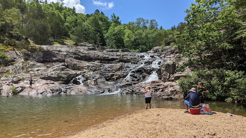
The Ozark Trail Association’s routes around St. Francois, Missouri, offer a distinct blend of rugged adventure and accessible day hikes that challenge the body and engage the mind. Here, the forest breathes around you—tall oaks and hickories lean into the path, while underfoot, the trail alternates between packed dirt and loose rock. This is hiking that demands respect but rewards with sweeping views over hills carved by ancient rivers.
Starting from the St. Francois section, expect trails that span between 5 and 15 miles with elevation gains up to 1,200 feet—enough to get your heart rate up without requiring mountaineering gear. The terrain shifts from shaded creek crossings, where water beckons and sometimes dares your progress, to dry ridges that open panoramic views of the Ozark Highlands. Watch for patches of sandstone and limestone that crack underfoot, testifying to the land’s slow, relentless shaping.
Not just a walk in the woods, these hikes strike a balance between adventure and approachability. Practical planning includes starting early to avoid midday heat, especially in summer, and packing layered clothing for quickly changing weather. Footwear should feature solid tread and ankle support—rolling an ankle on loose shale here is a quick way to slow down or end your day. Hydration is non-negotiable: creeks exist but flow depends on recent rains, so carry sufficient water.
Beyond physical endurance, hiking here introduces you to nature with personality—the creek edges chatter as if trading secrets, leaves overhead rustle with a subtle warning of incoming storms, and the wind plays a constant, sometimes insistent, rhythm among the pines.
Seasonally, spring showers swell creeks and unveil wildflowers like Missouri primrose, while fall transforms the forest into a fiery mosaic. Winter’s bareness simplifies navigation and grants unparalleled quiet, but requires added layers and caution on icy patches.
To prepare, take note that the trail intersects roads at several points allowing flexible loop options or early exits. Maps from the Ozark Trail Association and GPS apps hold the key to navigating these less-marked paths.
This region demands attentiveness: it’s fiercely itself. Respecting the trail’s unpredictable elements will turn your hike from a simple walk to an immersive experience. In every step, you negotiate with a landscape both resilient and evolving, where effort meets reward under open skies and amid whispering woodlands.
Nearby Trips
All Adventures
Boat Charters
Water Activities
Adventures near St. Francois, Missouri
Discover the unique and memorable adventures that make St. Francois, Missouri special.
Frequently Asked Questions
Are the Ozark Trail Association hikes in St. Francois suitable for beginners?
Many sections are moderate in difficulty and manageable for beginners with decent fitness, but some segments feature elevation gains and rocky terrain that require caution and good footwear.
Is there potable water along the trail?
Natural water sources like creeks exist, but their flow varies by season and rainfall. It’s best to carry your own water or treat any collected water to be safe.
What is the best time of day to hike in this area?
Early morning is generally best. Cooler temperatures and softer light improve safety and enhance the experience, especially during warmer months.
Are pets allowed on the trails?
Dogs are permitted but must be kept on a leash due to local wildlife and possible steep or rough terrain sections.
What wildlife might I encounter?
Expect white-tailed deer, wild turkeys, and various songbirds. Watch for venomous snakes resting under rocks or logs during warmer months.
How well marked are the trails?
The Ozark Trail Association maintains signs and blazes, but some intersections are less marked, so carrying a map or GPS is recommended.
Recommended Gear
Sturdy Hiking Boots
Critical for uneven terrain and protecting ankles on rocky, shifting ground.
Hydration System or Water Bottles
Ensure you carry enough water, especially as creeks can be unreliable.
Layered Clothing
Weather swings require quick adaptability, so layering helps maintain comfort throughout the hike.
Navigation Tools (GPS/Map & Compass)
For route-finding and safety on less-marked or intersecting trails.
Local Insights
Hidden Gems
- "The ‘Devil’s Honeycomb’ rock formations east of the main trail provide unique geological photo ops away from crowded paths."
- "A small hidden waterfall near Lost Creek is accessible by a short detour and is especially scenic after spring rains."
Wildlife
- "Missouri’s eastern box turtle lives here, often spotted on warm mornings sunning itself on flat rocks."
- "Ruffed grouse, well camouflaged, can be heard drumming in early spring."
History
"The region carries traces of early lead mining activity, with some old mining roads converted into parts of the trail system, blending natural scenery and historical roots."