Hiking the Sentiero Valtellina: A Practical Alpine Journey in Sondrio, Italy
The Sentiero Valtellina in Italy offers a balanced alpine hike along the Adda River valley, blending accessible terrain with compelling mountain views. Perfect for adventurers who want an immersive yet manageable trek, the route delivers nature’s force and local culture within a practical frame.
Choose Footwear for Mixed Terrain
Opt for hiking shoes with grip suitable for gravel, dirt, and occasional wet surfaces to maintain traction and avoid slips.
Hydrate Frequently
Carry at least 1.5 liters of water daily since village water stops are spaced; alpine sun and altitude increase dehydration risk.
Plan for Variable Weather
Layered clothing prepares you for cool mornings and warmer afternoons; sudden alpine wind shifts can refresh or chill unexpectedly.
Start Early for Best Light
Morning hikes reveal softer light on forests and mountains, plus quieter trails before day visitors arrive.
Hiking the Sentiero Valtellina: A Practical Alpine Journey in Sondrio, Italy
Stretching over 120 kilometers along the Adda River valley, the Sentiero Valtellina invites hikers to engage with the Alps on their own terms. This mostly gentle trail winds through forested slopes and open vineyards, brushing past mountain villages that challenge the usual pace of travel. Rather than an arduous summit assault, it’s a steady conversation with terrain that shifts from river valleys to rolling foothills.
Starting in Grosio and extending to Tirano, the route lies largely between 300 and 700 meters in elevation, with occasional sweeps up to 900. The terrain favors gravel paths, forestry tracks, and quiet country roads, making it accessible but not trivial. Over days, hikers track the river’s determined flow—sometimes darting alongside it, other times climbing to catch panoramic views where the water dares to curve beneath thick foliage.
Preparation matters. Proper hiking shoes with solid grip keep footing secure on gravel or occasional muddy patches, while layered clothing answers the alpine moods from cool mornings to sunlit afternoons. Water sources are plentiful in villages, but carrying at least 1.5 liters per day guards against thirst. Early spring and late autumn offer crisp air and solitude, while summer brings long light and blossoming chestnut woods.
Navigation is mostly straightforward, guided by clear signage and local maps. However, some detours through smaller hamlets require attention and willingness to adjust pace. The trail speaks most to those eager to absorb the landscape in detail: churches wrapped in sun, streams pushing forward through rocky beds, and the steady scent of pine blending with vineyard perfumes.
This isn’t a rush to conquer altitude but an invitation to read the land—respecting its rhythms and challenges. It’s the kind of trail where every step is an exchange with a landscape fiercely itself, rewarding preparations and patience with moments of quiet clarity and expansive views of the Ortler Alps. Whether you’re pacing yourself day-to-day or moving briskly for a multi-stage trek, Sentiero Valtellina offers a route both scenic and sensible for immersive alpine exploration.
Nearby Trips
All Adventures
Boat Charters
Water Activities
Adventures near Sondrio, Italy
Discover the unique and memorable adventures that make Sondrio, Italy special.
Frequently Asked Questions
How long does it take to hike the entire Sentiero Valtellina?
Completing the full length typically requires 4 to 8 days depending on your pace and chosen daily distances. Many hikers break it into stages ranging from 15 to 30 kilometers per day.
Is the Sentiero Valtellina suitable for beginner hikers?
Yes, the trail’s mostly gentle elevation and well-marked sections cater to beginners with a decent fitness level, but some experience with longer day hikes and basic navigation is helpful.
Are there places to refill water along the route?
Villages along the trail offer reliable water access at public fountains, cafés, or shops. It’s still best to carry sufficient water between stops.
Can I hike the trail year-round?
While technically possible, winter brings snow and icy conditions requiring caution or alternate arrangements. Spring to fall are ideal for safer footing and better weather.
Is the route suitable for mountain biking or trail running?
Parts of the trail accommodate mountain biking, especially on gravel and rural roads, but sections with footpaths or uneven terrain can be tricky. Trail runners will find varied terrain and manageable elevation.
Are there accommodations along the Sentiero Valtellina?
Yes. Small guesthouses, agriturismi, and hotels in towns and villages along the path provide lodging and meals, making multi-day staging practical.
Recommended Gear
Sturdy Hiking Shoes
Provides traction and protect feet across gravel, dirt tracks, and occasional wet spots.
Layered Clothing
Adjustable layers safeguard comfort against variable alpine temperatures and weather.
Hydration System or Bottles
Reliable water carrying capacity is vital as natural water sources are limited or spaced out.
Weatherproof Jacket
Protects against wind, rain, and sudden cold blasts typical of alpine environments.
Local Insights
Hidden Gems
- "Belvedere di San Giuseppe offers panoramic views over Sondrio and the valley’s curves."
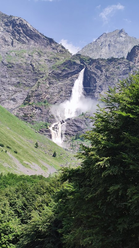
- "The Cascate del Thures waterfall near Grosio bursts like a hidden alpine show after rainfall."
Wildlife
- "Keep an eye out for red deer that graze quietly in forest clearings."
- "Golden eagles occasionally soar above the ridge lines in late summer."
History
"The Sentiero Valtellina follows ancient trading and migration paths used for centuries, reflecting the region’s agricultural heritage and strategic alpine role."