Ice Lakes Basin Hike: Navigating Silverton’s Alpine Playground
Ice Lakes Basin in Silverton, Colorado, presents an unforgettable alpine hike where vivid turquoise lakes meet jagged peaks in a rugged, high-elevation landscape. This guide combines detailed trail info with essential tips, ensuring you're ready for both the challenge and the thrill.
Start Early to Beat Afternoon Thunderstorms
Thunderstorms develop rapidly in the afternoon at high elevation, so hit the trail early, ideally by 7 AM, to avoid dangerous weather.
Hydrate Frequently
Carry a minimum of two liters of water and sip regularly to combat altitude dehydration, as the dry mountain air and exertion can sneak up on you.
Wear Sturdy, Traction-Enhanced Footwear
The trail’s uneven surfaces, from loose scree to rocky slabs, require hiking boots or shoes with solid grip to minimize slipping risk.
Pack Layers for Rapid Temperature Changes
Weather shifts quickly in alpine zones. Bring windproof and insulating layers to adapt from sunny trail sections to exposed, chilly summits.
Ice Lakes Basin Hike: Navigating Silverton’s Alpine Playground
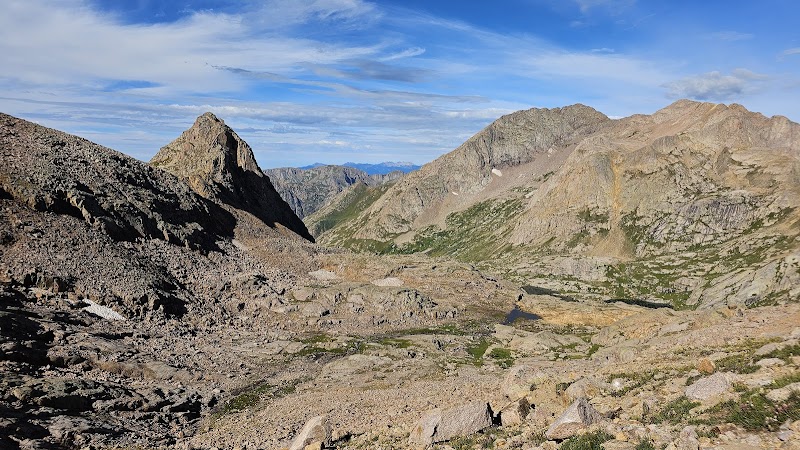
Set against the rugged backdrop of southwestern Colorado, the Ice Lakes Basin hike offers a high alpine journey that balances sheer beauty with a solid challenge. This 7.2-mile round trip stretches along steep switchbacks and rocky terrain, climbing approximately 1,900 feet to reveal a string of six vivid turquoise lakes cradled by jagged peaks. From the outset, the trail commands respect as it weaves through spruce and fir forests where the trees seem to lean closer, whispering warnings about the elevation. Eventually, the landscape breaks open, and the wind takes hold—whipping through granite spires with a force that demands focus and stamina. The vibrant colors of the ice-fed lakes below aren’t just scenic snapshots; they reflect the alpine environment’s relentless energy and the purity carved by winter's hold.
Practical preparation is key. Proper footwear with good traction is non-negotiable as the path shifts between loose scree and solid rock. Around 4 to 6 hours typically cover the terrain for most hikers, allowing time for breaks to hydrate and take in the shifting vistas. Water supply is a must; carry at least two liters, as natural sources along the trail are cold and swift but not always accessible. Start early in the day to avoid afternoon thunderstorms that build swiftly in the high country—a fierce reminder that nature here calls the shots.
Wildlife occasionally crosses the path—marmots pause to peer curiously while mountain goats may appear on distant cliffs, testing your attention with their surefooted agility. Bring a camera but also bring respect: the fragile alpine ecosystem demands that you leave no trace and tread lightly.
The trail concludes in the basin’s heart, where the lakes gather like jewel pools beneath towering peaks. This spot demands full engagement—sit on the crystalline shoreline, listen to the wind’s conversation with the peaks, and absorb the stark contrast between the wilderness’s harshness and its quiet moments of grace.
Whether you’re chasing physical accomplishment or craving a vivid connection to the alpine wild, Ice Lakes Basin offers a high-altitude experience that’s both exhilarating and humbling. Plan thoroughly, prepare wisely, and set out with respect for a landscape that remains fiercely itself.
Nearby Trips
All Adventures
Boat Charters
Water Activities
Adventures near Silverton, Colorado
Discover the unique and memorable adventures that make Silverton, Colorado special.
Frequently Asked Questions
How difficult is the Ice Lakes Basin hike?
The hike is challenging due to its steep 1,900-foot elevation gain over a relatively short distance of 3.6 miles one-way. The terrain includes sections of loose rocks and exposed alpine ridges, requiring good fitness and sure footing.
When is the best time to visit Ice Lakes Basin?
The best window is from mid-July through early September when the trail is generally free of snow and the weather is most stable. Early mornings help avoid afternoon thunderstorms common in summer.
Are dogs allowed on the Ice Lakes Basin Trail?
Dogs are allowed but should be kept on leash due to wildlife and fragile alpine environments. Prepare to carry water for them and be mindful of the trail’s difficulty.
Is it possible to camp near Ice Lakes Basin?
Backcountry camping is permitted with a permit from the Uncompahgre National Forest, but campers must follow Leave No Trace principles and avoid sensitive lake edges to protect water quality and habitat.
What wildlife might I encounter during this hike?
Marmots, pikas, mountain goats, and occasionally black bears live in the area. Wildlife tends to be shy, so keep a respectful distance and secure food properly.
Are there any safety concerns unique to this hike?
Altitude sickness is a real risk given the start elevation around 10,300 feet, climbing to over 12,000 feet. Also be prepared for sudden weather changes and avoid hiking alone if unfamiliar with mountain terrain.
Recommended Gear
Hiking boots with good traction
Necessary for stability and protection on mixed rocky and scree trail sections.
Hydration system or water bottles
To maintain adequate hydration in dry, high-elevation conditions.
Layered clothing including windproof jacket
Protects against rapid weather changes and the chill of exposed alpine sections.
Sun protection (hat, sunscreen, sunglasses)
High altitude sun is intense; these essentials prevent burns and glare-related eye strain.
Local Insights
Hidden Gems
- "The upper basin offers a less frequented viewpoint from a ridge north of Mirror Lake with sweeping views of the entire chain of Ice Lakes."
- "Check out the natural stone scree fields on the final ascent, where wildflowers cling tenaciously between the rocks."
Wildlife
- "Watch for the barking calls of yellow-bellied marmots along rocky ledges."
- "Mountain goats sometimes appear along the upper ridges, blending invisibly into the granite cliffs."
History
"The trail follows mining routes dating back to the silver booms of the late 19th century. Evidence of old camps and faint mine shafts peek from forested areas along the lower sections."