Hiking the Long Mynd: Commanding Views Across Shropshire’s Wild Heart
The Long Mynd offers hikers a rare encounter with Shropshire’s expansive moorland and rugged ridges. From Bishops Castle, adventurers can experience a demanding but accessible trail that delivers panoramic countryside views and a genuine connection with England’s wild heart.
Wear Sturdy Hiking Boots
The Long Mynd’s varied terrain includes soft grass, rocky outcrops, and shale paths, requiring reliable footwear with good grip and ankle support.
Carry Adequate Water
No streams along the upper trails mean dehydration is a real risk, especially in summer; bring at least 2 liters per person.
Check Weather Before You Go
Weather shifts fast here. A clear morning can turn into thick mist, so pack layers and a waterproof jacket to stay safe and comfortable.
Use a Map and Compass
GPS signals can be patchy on the moor; traditional navigation tools will help you stay on track and avoid accidental detours.
Hiking the Long Mynd: Commanding Views Across Shropshire’s Wild Heart
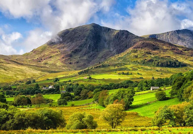
The Long Mynd rises above the Shropshire countryside near Bishops Castle, offering an immersive hiking experience that balances wild beauty with accessible challenge. Stretching some 15 kilometers from the Cardingmill Valley, the terrain varies from rolling heather moorland to stony ridges, each step revealing ever-expanding views. The landscape here is fiercely itself, with winds that push forward and clouds that sweep low, commanding your respect and encouraging steady progress.
The typical route covers roughly 10 miles (16 km), with an elevation gain of about 500 meters, combining open plateau walks with intermittent forest patches where the trees lean as if testing your resolve. The underfoot conditions can shift from soft grass to exposed shale, so solid boots are a must. As you ascend, the ever-changing panorama unfolds: quiet farming valleys below, craggy outcrops above, and the Welsh hills pressing the horizon.
Timing your hike is crucial. Early morning often rewards adventurers with clearer air and wildlife stirring—watch for red kites circling like guardians of the sky, while the heather smells fresh after dew. Midday brings a harsh sun, so hydration and sun protection are essential on exposed stretches. Weather can be abrupt, with mist rolling in from the west, draping the moor in a shroud that demands cautious navigation.
Starting from Bishops Castle, the town itself is a practical base with cozy pubs, local produce shops, and friendly faces that make gear checks and post-hike recovery feel personal. Parking is available at Cardingmill Valley car park, the classic trailhead, and from there the path snakes upward.
Navigation is straightforward but not to be taken lightly—clear markers and established trails keep you on course, but once on the ridge, wind-swept patches challenge concentration. A reliable map and compass or GPS device add peace of mind.
The Long Mynd hike is an invitation to engage deeply with Shropshire’s natural rhythms. Each vantage point throws open the countryside like a living map: patchwork fields, the winding River Corve daring you to follow it downstream, and birds that claim the thermals as their own. This is a trail that rewards curiosity, preparation, and respect for its raw, open character.
In practical terms, pack layers for all conditions, bring a full water supply, and plan for a 5-7 hour trek depending on pace. Your reward is not only the view from the heights but the sense of traversing a landscape that remains boldly independent, fiercely alive beneath your feet.
Nearby Trips
All Adventures
Boat Charters
Water Activities
Adventures near Shrewsbury
Discover the unique and memorable adventures that make Shrewsbury special.
Frequently Asked Questions
How long is the typical Long Mynd hike from Cardingmill Valley?
A common route measures about 10 miles (16 km) and generally takes between 5 and 7 hours to complete, depending on pace and stops.
Is the Long Mynd suitable for beginner hikers?
While not overly technical, it requires moderate fitness due to distance and elevation. Beginners can tackle shorter sections or take it slow.
Are there facilities at the trailhead near Bishops Castle?
Yes, Cardingmill Valley features a small visitor center, toilets, and parking. Nearby Bishops Castle offers shops and cafes for supplies or meals.
What wildlife might I encounter on the Long Mynd?
Expect to see red kites soaring overhead, meadow pipits flitting through grass, and possibly deer within wooded patches.
When is the best time of day to hike the Long Mynd for photography?
Early mornings offer softer light and less wind, while late afternoon can present dramatic skies perfect for landscape shots.
Is the trail well-marked and easy to follow?
Generally yes, but weather can obscure markers. It’s recommended to carry a map and compass to stay safely on course.
Recommended Gear
Waterproof Hiking Boots
Protect feet from wet, uneven ground and provide ankle support on rocky sections.
Layered Clothing
Allows adaptation to rapidly changing weather conditions on the moor.
Map and Compass
Essential navigation tools for areas where GPS can be unreliable.
Sun Protection
Hat, sunscreen, and sunglasses are necessary for exposed trail sections in bright daylight.
Local Insights
Hidden Gems
- "The heart-shaped bog near the Stiperstones edge, a rare and untouched wetland area."
- "Suntrippe Stone, an ancient prehistoric megalith overlooked by many hikers."
- "The Devil's Mouth, a narrow cleft offering a thrilling vantage into the Welsh borderlands."
Wildlife
- "Red kites, whose graceful circles dominate the skyline"
- "Mountain hares, sometimes spotted in spring"
- "Heather bees buzzing amid flowering moorland"
History
"The Long Mynd has long served as a boundary and passageway between England and Wales, with iron age hillforts dotting the landscape and evidence of medieval farming practices still etched into terraces."