Conquering the Yorkshire Three Peaks: A Practical Guide to Settle’s Greatest Challenge
The Yorkshire Three Peaks Challenge offers a demanding 24-mile trek across Pen-y-ghent, Whernside, and Ingleborough—fierce limestone giants that reward persistence with dramatic vistas. Ideal for hikers prepared to balance endurance with careful planning, this route around Settle delivers a day of rugged terrain, shifting weather, and unforgettable countryside views.
Start Early to Beat Crowds and Weather
Begin your hike at dawn to avoid the busiest times and have a wider margin in case of weather delays.
Choose Durable Footwear
Wear broken-in, waterproof hiking boots with solid grip to handle slippery limestone and muddy patches.
Carry Adequate Hydration
Use a hydration pack with at least 2 liters of water; springs are unreliable and streams can slow to a trickle.
Use Navigation Tools
A map and compass are crucial, especially in poor visibility; GPS is a helpful backup, not a substitute.
Conquering the Yorkshire Three Peaks: A Practical Guide to Settle’s Greatest Challenge
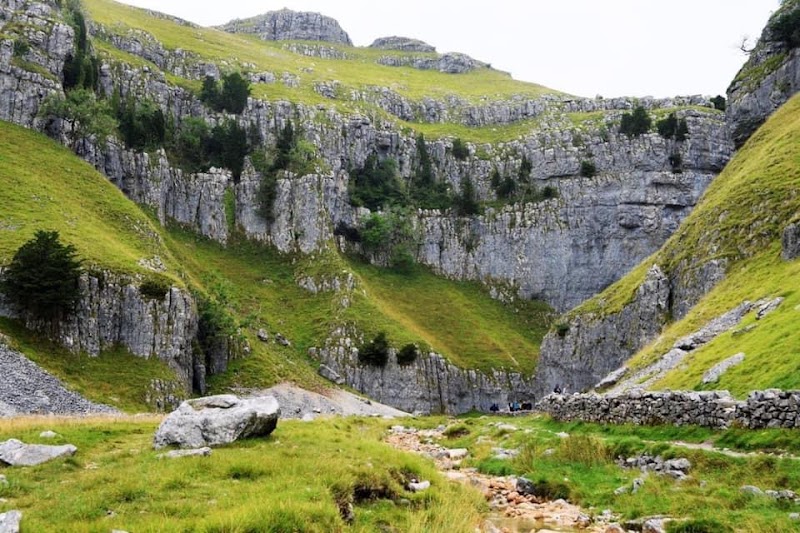
The Yorkshire Three Peaks Challenge demands more than stamina—it calls for respect. Stretching over 24 miles, this iconic route runs a rugged circuit around the market town of Settle, guiding you over Pen-y-ghent, Whernside, and Ingleborough. These three limestone giants don’t just rise from the earth; they dare you to test your limits with a combined ascent of nearly 5,200 feet. From quiet forest trails shadowed by ancient trees to open moorlands where the wind plays its unyielding game, the terrain shifts beneath your boots, compelling focus and adaptation.
Begin early if you want to outrun the mid-day sun and avoid the busiest hours on the paths. Your feet will thank you for choosing sturdy, well-broken-in hiking boots; the uneven mix of gravel, stone slabs, and muddy patches demands reliable traction. Bring enough water—streams may tempt with cool clarity, but their flow is unpredictable and often slow. Lightweight hydration packs ease this necessity, while energy-dense snacks keep your pace sharp across the trail's many climbs and descents.
Pen-y-ghent greets you first with its steep slopes carved by centuries of rain and wind. The path winds up with patches of heather and gritty scree, and once at the summit, sweeping views unfurl, framing distant fells and patchworked farmland. Whernside, the highest peak, challenges you with a longer climb across steeper ridges. Its summit offers a raw panorama where the sky feels close enough to touch, clouds drifting like restless spirits. Ingleborough’s cracked cliffs and distinctive flat top provide a finale both dramatic and unyielding; here, natural caves and limestone pavements remind you the land holds stories beyond the path.
Plan for a full day, typically 10 to 12 hours depending on pace and breaks. Weather shifts quickly; layered clothing will shield you from sudden chills or warming sun. Navigation can grow tricky in fog or rain, so a map and compass—or GPS as backup—are essential. Respect the challenge's physical demands, acknowledging the routes are not simply scenic strolls but encounters with terrain fiercely itself.
Completing the Yorkshire Three Peaks is a conversation with the hills: loud in effort, quiet in reflection. This route isn’t about conquering nature but matching its rhythm and earning its respect. For anyone ready to engage deeply with the land and push personal boundaries, Settle’s challenge waits with steady arms and an unspoken dare—are you ready to answer?
Nearby Trips
All Adventures
Boat Charters
Water Activities
Adventures near Settle, North Yorkshire
Discover the unique and memorable adventures that make Settle, North Yorkshire special.
Frequently Asked Questions
How difficult is the Yorkshire Three Peaks Challenge for a casual hiker?
The challenge is undoubtedly demanding due to its 24-mile distance and roughly 5,200 feet total elevation gain. Casual hikers with a reasonable fitness base can complete it, but should prepare for at least 10 hours on their feet and varied terrain. Training hikes and pacing are critical.
Are there water sources along the route?
Streams and springs appear sporadically but should not be relied upon exclusively for hydration. Water flow varies seasonally and may be sluggish or stagnant. Carrying sufficient water from the start is recommended.
Is the trail well marked?
Sections are marked but can be difficult to follow in poor weather, especially on the open moor. A map and compass, and familiarity with the route, are essential. GPS devices help but should not replace traditional navigation tools.
What wildlife might I encounter?
You’ll commonly see red grouse, skylarks singing overhead, and occasionally elusive mountain hares on the higher moors. Birdsong and small mammals animate the quieter valleys.
Can the challenge be split over multiple days?
Yes, many hikers break the route into two or more days to enjoy the highs without rush. There are accommodations and campsites in and around Settle for overnight stays.
What should I know about local weather conditions?
North Yorkshire weather can change rapidly, with sun turning to fog or rain in moments. Wind speeds on ridges can be strong, so planning for layered clothing and weatherproof outerwear is essential.
Recommended Gear
Waterproof Hiking Boots
Protect feet from wet conditions and provide grip on slippery sections of limestone and mud.
Layered Clothing
Allow quick adjustment to changing temperatures and conditions from dawn to dusk.
Hydration Pack
Ensures ample water supply without frequent stops, indispensable during warm months.
Map and Compass
Essential for navigation through fog or low visibility conditions on open moorland.
Local Insights
Hidden Gems
- "Peggy's Ark, an isolated limestone pillar visible from Whernside summit"
- "Vicar's Bridge, an ancient stone structure along the trail after Pen-y-ghent"
Wildlife
- "Mountain hares that blend with the moorland"
- "Skylarks whose song fills open stretches"
- "Red grouse lurking under heather beds"
History
"The area has long been a pastoral landscape, with dry stone walls marking centuries-old farming boundaries. Caves around Ingleborough once sheltered ice-age hunters, weaving human stories tightly into the landscape."