Feel the thrill of crossing one of the world’s longest suspension footbridges high above the Austrian Alps. The highline179 near Reutte combines rugged mountain hiking with jaw-dropping views, promising an invigorating adventure for all skill levels.
Wear sturdy, grippy footwear
The trail has sections of uneven terrain and the bridge surface can be slippery. Hiking boots or trail runners with good tread will keep you steady.
Bring enough water
Alpine air is drying, especially on the exposed bridge; carry at least 1.5 liters per person to stay hydrated throughout the 2-3 hour hike.
Start early to avoid crowds and wind
Mornings are generally calmer and cooler, providing a safer and more pleasant crossing experience.
Check weather forecasts carefully
Strong winds, rain, or fog can make the bridge crossing hazardous or limit visibility. Postpone your hike if adverse weather is predicted.
Conquer the Highline179: Austria’s Sky-High Suspension Bridge Adventure
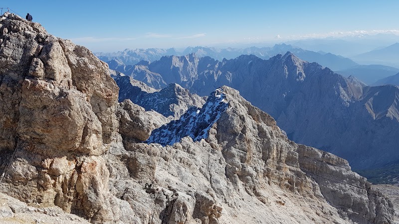
Suspended nearly 114 meters above the Rosshütte Valley, the highline179 in Reutte challenges your balance and rewards you with expansive Alpine panoramas. Stretching 406 meters, it’s one of the longest suspension footbridges on the planet, daring you to cross its swaying path linking Fort Claudia and Fort Ehrenberg. This isn’t just a walk—it’s an invitation to engage with a fierce mountain environment, where every gust of wind shifts beneath your feet and the forested slopes watch silently.
Starting at Fort Claudia, a historic bastion perched strategically on rocky cliffs, the hike introduces you to a rugged trail that gains about 350 meters in elevation. The initial woodland path winds steadily upward, offering cool shade and glimpses of the valley below where the rapids of the Lech River surge restlessly against rocky banks.
Approaching the bridge, your heartbeat might quicken—not from the climb, but the sheer suspension of the structure itself. At 114 meters high, the highline179 tests your nerves as it arches across the abyss. Its steel cables and wooden planks breathe underfoot, responding to each step like a living thing. The view dominates: distant snow-capped peaks mingle with thick spruce forests, and looking down, the river dares you to keep moving forward.
Beyond the bridge, the path continues to Fort Ehrenberg, a fortress with centuries of history guarding this critical pass. The route back offers an easier descent. Overall, the loop totals roughly 8 kilometers and demands moderate fitness, but the steady incline and exposed bridge segment require sure-footedness.
Hydration is crucial—the alpine air can dry your throat before you realize it. Solid trekking shoes with good grip stabilize your footing on both natural trail and constructed bridge. Starting early taps into calm morning winds and fewer crowds. Weather changes quickly up here; packing a windproof layer is smart.
While the highline179 is a spectacle on its own, the nearby town of Reutte makes a convenient base with amenities, lodging, and local guides. Visiting outside peak summer months offers quieter trails and enhanced wildlife encounters, but spring and fall bring potential rain or early snow. Overall, this hike balances thrill and accessibility, letting you step into a landscape that is uncompromisingly alpine and sharply alive.
Nearby Trips
All Adventures
Boat Charters
Water Activities
Adventures near Reutte
Discover the unique and memorable adventures that make Reutte special.
Frequently Asked Questions
Is the highline179 safe for children and nervous hikers?
While the bridge is structurally sound and regularly maintained, it can sway and feels exposed, which may be intimidating. Children are allowed but should be supervised closely. Those uncomfortable with heights should consider whether the crossing suits their comfort level.
Are there entry fees or permits required to cross the bridge?
Yes, the highline179 charges a small entrance fee payable at the trailhead or online, used for maintenance and conservation efforts.
What’s the best way to reach the starting point of the hike at Fort Claudia?
The trailhead is accessible by car with parking available near Fort Claudia. Public buses connect Reutte town center to the area, but schedules vary seasonally.
Can you cross the bridge in bad weather?
No, crossing is not recommended during high winds, heavy rain, or thunderstorms due to safety risks. The bridge may be temporarily closed under such conditions.
Is the hike suitable for dogs?
Dogs are allowed but must be kept on a leash for their safety and to respect other hikers. Be prepared to help your dog with the bridge crossing if they are nervous.
Are there food or water sources along the trail?
There are no food or water stations on the trail itself. Plan to bring your own supplies, and consider refilling in Reutte before or after your hike.
Recommended Gear
Hiking boots or sturdy trail shoes
Provides grip and ankle support essential for uneven, sometimes slippery terrain.
Water bottle or hydration pack
Keeps you hydrated; crucial due to dry alpine air and physical exertion.
Windbreaker or light waterproof jacket
Protects against sudden alpine winds and occasional rain on the exposed bridge.
Sun protection (hat, sunscreen, sunglasses)
High altitude sun is intense—taking precautions against sunburn and glare is essential.
Local Insights
Hidden Gems
- "The 'Kaiserschützensteig' viewpoint just past Fort Ehrenberg offers less-visited, sweeping valley views."
- "A small cave near the trail’s midpoint offers a quiet spot to pause and listen to dripping water and forest sounds."
Wildlife
- "Red deer and marmots frequent the surrounding forested slopes, especially in early morning or late afternoon."
- "Birds of prey, like the peregrine falcon, occasionally circle above the bridge area, adding to the wild atmosphere."
History
"The two forts linked by the bridge—Claudia and Ehrenberg—date back to the 17th and 14th centuries, respectively, guarding vital routes in the Tyrol region. They form a strategic historical backdrop to the hike."