Trailblazing the Sunshine Coast Trail: Mountains, Forests, and Ocean Views in Powell River
The Sunshine Coast Trail offers hikers an intense and varied journey through British Columbia’s coastal wilderness. From mountain ridges to seaside bluffs near Powell River, this trail is a practical yet rewarding challenge for those seeking adventure off the beaten path.
Pack Water Purification Gear
Although fresh water sources are abundant, filtering or treating water is essential to avoid illness. Carry a reliable purifier or treatment tablets.
Wear Durable, Waterproof Footwear
Terrain varies from wet, mossy roots to rocky scrambles. Waterproof boots with good ankle support will keep you comfortable and stable.
Plan for Variable Weather
Rain can fall any day, and coastal winds will test your layering system. Prepare for damp and windy conditions especially above the tree line.
Allow 7-10 Days for Completion
The complete trail stretches 180 kilometers with 4,500 meters of elevation gain. A steady pace and flexibility in your schedule ensure a rewarding experience.
Trailblazing the Sunshine Coast Trail: Mountains, Forests, and Ocean Views in Powell River
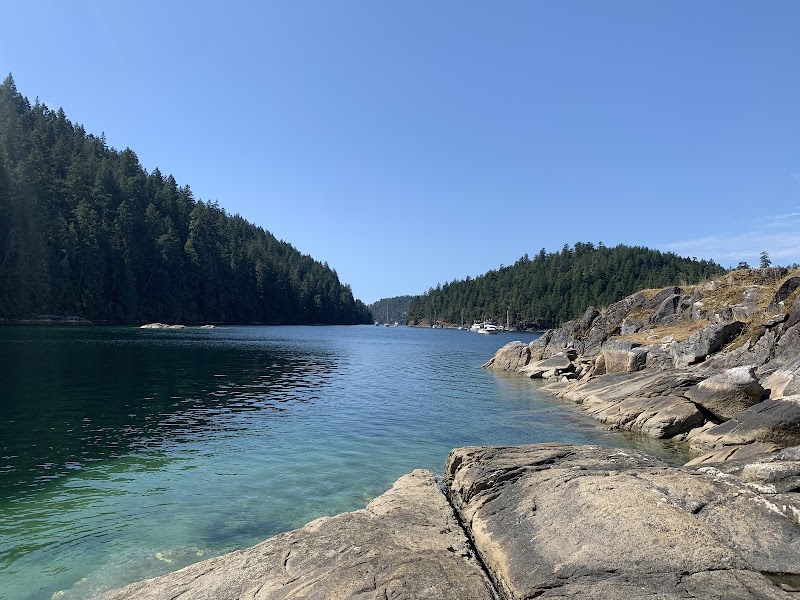
Stretching 180 kilometers through British Columbia’s rugged wilderness, the Sunshine Coast Trail invites hikers into an unbroken journey from mountainous heights to the rugged Pacific shoreline. Beginning near Powell River, this all-season trail winds through dense forests, tall peaks, and coastal edges where the sea dares you to linger. Expect a dynamic experience shifting from steep ascents and rocky ridges to quiet river crossings and moss-softened ground, each step revealing a fiercely individual landscape.
The hike covers varied terrain — expect uneven roots underfoot, moss-covered logs, and rocky scrambles. Elevation gain hovers around 4,500 meters total, presenting a steady physical challenge rather than overwhelming spikes. You’ll traverse areas ranging from old-growth Douglas fir stands to coastal bluffs with wind-carved vegetation, providing sweeping views that reward every climb.
Plan for 7 to 10 days, depending on pace and side trails explored. Days begin cool with morning mists clinging to evergreen spires and end under vast star fields free from city haze. Water sources are frequent but often need purification; the rivers and streams throughout the trail push forward with fresh urgency. Footwear should be sturdy and water-resistant to manage wet sections and slippery rocks.
Prepare for variable weather; coastal rain is common even in summer and wind can add a sharp edge on exposed ridges. Timing your trip between June and September provides the most stable conditions. Early spring can still hold snow in higher sections, and fall offers brilliant color but shorter daylight hours.
While the trail tests endurance and navigation, it rewards with solitude and raw natural beauty. Camp near quiet bays or beneath towering cliffs where the ocean breeze whispers across the trees. Each segment holds a distinct character— from the steep climbs of the Pacific Highlands to the gentle descents toward ocean coves—making this trail a true adventure of contrasts.
Whether you’re a seasoned backpacker or an eager adventurer ready to push limits, the Sunshine Coast Trail provides an immersive way to connect with British Columbia’s wild heart—one purposeful step at a time.
Nearby Trips
All Adventures
Boat Charters
Water Activities
Adventures near Powell River
Discover the unique and memorable adventures that make Powell River special.
Frequently Asked Questions
How difficult is the full Sunshine Coast Trail?
The trail is challenging due to its length (180 km), elevation change (approximately 4,500 m), and varied terrain, which includes steep ascents, rocky paths, and river crossings. It requires solid fitness and hiking experience.
Can the trail be hiked in sections?
Yes, many hikers complete the trail in sections over multiple trips. There are accessible trailheads and campsites along the route that allow shorter day hikes or multi-day backpacking trips.
What wildlife might I encounter on the trail?
Expect black bears, deer, eagles, and a variety of small mammals. Always store food securely and maintain awareness, especially near fresh water sources.
Is water readily available on the trail?
Water sources appear regularly via streams and rivers, but all water should be treated or filtered before drinking to avoid waterborne illnesses.
When is the best time to hike the Sunshine Coast Trail?
Late June to early September offers the most stable weather and longer daylight hours, making it the optimal window for hiking the entire trail.
Are permits or fees required to hike the trail?
No permits are required for hiking the Sunshine Coast Trail, but some camping areas may require reservations or have limitations to reduce environmental impact.
Recommended Gear
Water Filtration System
Ensures safe drinking water from streams, essential for hydration and health on a long trail.
Waterproof, Sturdy Hiking Boots
Protects feet on wet mossy sections and rocky climbs, providing support and comfort over rough terrain.
Layered Clothing System
Allows quick adaptation to temperature shifts and rainy conditions common on the coast.
GPS Device or Map & Compass
While trails are marked, navigation can be tricky in dense forests or poor weather; carry reliable tools.
Local Insights
Hidden Gems
- "The detour to Mt. Troubridge summit offers a panoramic view rarely crowded by hikers."
- "Quieter beach access points near Savary Island provide serene coastal stops away from main campsites."
Wildlife
- "Watch for the elusive coastal Pacific marten in forested areas, active mostly at dawn and dusk."
- "Eagles frequently soar above the fjords, especially in late summer when salmon run begins."
History
"The trail traverses traditional territories of the Tla’amin Nation and follows old forestry and mining routes, with some historical logging camps still evident along the way."