Best Scenic Day Hikes in the Presidential Range Near North Conway: Iconic Peaks and Hidden Trails Guide
Explore the Presidential Range near North Conway with day hikes that combine iconic mountain summits and quiet, hidden trails. This guide offers practical details and vivid descriptions to prepare you for thrilling yet manageable adventures in one of New England’s most dramatic landscapes.
Start Early for Clear Skies and Cooler Air
Begin hikes at dawn to avoid afternoon storms and enjoy more stable weather, especially above tree line where conditions change rapidly.
Bring Layered Clothing
Temperatures drop sharply at higher elevations; wear moisture-wicking layers and pack windproof jackets to adjust on the go.
Hydrate Thoroughly
Carry at least 2 liters of water per person; natural streams may look inviting but should be treated or filtered before drinking.
Wear Sturdy Footwear
Rough terrain with rocks and roots demands hiking boots with good grip and ankle support to prevent injuries.
Best Scenic Day Hikes in the Presidential Range Near North Conway: Iconic Peaks and Hidden Trails Guide
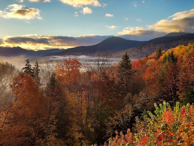
The Presidential Range near North Conway, New Hampshire, stands as a fierce frontier of rugged peaks, dense forests, and brisk mountain air that demand attention. For those seeking day hikes that mix breathtaking vistas with approachable routes, this guide lays out the best trails, from celebrated summits to lesser-known paths that slip quietly through the wild.
Start with Mount Washington, the highest point in the Northeast at 6,288 feet. The Tuckerman Ravine Trail offers a 4.5-mile hike (9 miles round trip) with nearly 3,800 feet of elevation gain. The trail throbs with energy — rivulets dart alongside the path, daring you upward, and at the summit, the jagged winds make their presence known, reminding you that this mountain commands respect. Expect rocky footing and steep pitches; good boots and steady pacing are essential.
For a less intense but no less scenic option, try Mount Chocorua via the Champney Falls Trail. This 5.3-mile loop rises about 2,000 feet, carving through hemlocks and white birches before opening onto panoramic views of the Ossipee Lake and Lake Winnipesaukee. The water cascades down Champney Falls, seemingly coaxing hikers through the forest’s shade. This trail balances challenge and reward well, making it a fine choice for varied skill levels.
If solitude is your goal, the Gulfside Trail from Mizpah Spring Hut leads to Mount Madison's summit. At roughly 9 miles round trip with 3,100 feet of gain, it demands a steady fitness level but offers sweeping views that are less trodden. The wind here carries secrets of the alpine zone, a living wilderness fiercely itself. Be ready for open ridgelines that expose you to sudden weather shifts.
Practical planning is critical: carry 2+ liters of water, wear sturdy boots with solid ankle support, and pack layers for changing temperatures. Poll the weather early; storms can rise fast. Aim to start morning hikes just as light breaks to maximize daylight and avoid midday heat or afternoon showers.
Each hike invites you to engage with the land deliberately — the Presidential Range is not just a backdrop but an active participant. Its rivers push and pull, rocks challenge your footing, and summits greet you with sharp-edged wind that insists on your focus. Respect these forces, prepare well, and these mountains will reward your effort with views and moments that stick.
Whether it's the iconic peaks or hidden trails, the Presidential Range near North Conway delivers an adventure that’s vivid, practical, and endlessly compelling.
Nearby Trips
All Adventures
Boat Charters
Water Activities
Adventures near North Conway
Discover the unique and memorable adventures that make North Conway special.
Frequently Asked Questions
What is the best trail for a first-time hiker in the Presidential Range?
Mount Chocorua via the Champney Falls Trail is ideal for beginners. It offers a moderate 5.3-mile loop with rewarding views and manageable elevation gain, making it an accessible introduction to the range’s terrain.
Are permits required to hike these trails?
No permits are necessary for day hiking the Presidential Range, but parking fees and trailhead regulations may apply in some areas, such as at Pinkham Notch.
What wildlife should hikers expect to encounter?
Black bears, moose, and white-tailed deer inhabit the region. Bird watchers may spot peregrine falcons or spruce grouse near higher elevations. Always observe wildlife from a distance and store food securely.
How quickly can weather change on these mountains?
Weather in the Presidential Range can shift rapidly. Clear mornings may turn to afternoon storms in under an hour, especially above the tree line. Staying aware and prepared for quick changes is vital.
Are dogs allowed on the trails?
Dogs are permitted on most trails but must be leashed. Be aware of local regulations and wildlife presence; high-elevation trails can be harsh and may pose risks to pets.
What are some lesser-known viewpoints worth visiting?
Gulfside Trail’s open ridgelines offer expansive views without the crowds found on Mount Washington. Additionally, the summit of Mount Madison reveals distant peaks rarely seen by casual hikers.
Recommended Gear
Hiking Boots with Ankle Support
Provides stability and traction over rocky, uneven ground commonly found in the Presidential Range.
Layered Clothing System
Allows quick adjustment to temperature swings common on exposed ridges and summits.
Hydration System or Water Bottles
Adequate water supply is crucial to tackle the physical and environmental demands of these trails.
Trekking Poles
Assist with balance and reduce stress on knees during steep descents or slippery sections.
Local Insights
Hidden Gems
- "Quiet ledges on Gulfside Trail with views of the Presidential peaks"
- "The basin area near Tuckerman Ravine is a peaceful spot for reflection"
- "Small waterfalls off the Champney Falls Trail, often overlooked by busy hikers"
- "The alpine zones on Mount Adams and Madison, less accessed but stunning"
Wildlife
- "Black bears roaming forest floors"
- "Moose visible from higher vantage points at dawn"
- "Peregrine falcons nesting on cliff faces in the higher zones"
- "Red squirrels and chipmunks darting beneath canopy layers"
History
"The Presidential Range is named for U.S. presidents and has been a hub of early conservation efforts since the 19th century. The Appalachian Trail slices through this range, linking a legacy of outdoor exploration and stewardship."